
Annandale, VA Real Estate: The Definitive Guide to Mid-Century Architecture, Accotink Watershed & Beltway Commuter Corridors
1. Executive Summary & Foundational Takeaways
Annandale, Virginia, occupies a pivotal central position within the spatial economy, transport topography, and residential fabric of Fairfax County. Positioned precisely ten miles west-southwest of central Washington, D.C., and bisected by the Interstate 495 Capital Beltway, Annandale serves as an established residential anchor defined by exceptional land-to-building ratios, mature deciduous tree canopies, and unmatched multi-directional highway accessibility.
Unlike chartered municipal jurisdictions in Northern Virginia, Annandale is an unincorporated census-designated place (CDP) governed directly by the Fairfax County Board of Supervisors. Its territory is shared primarily across the Mason Magisterial District to the east and the Braddock Magisterial District to the west. This jurisdictional reality carries profound fiscal and legal consequences for real property owners: homeowners in Annandale enjoy the complete civil resources, public safety infrastructure, and planning administration of Fairfax County without being subjected to secondary town-level real estate taxes or autonomous municipal zoning commissions.
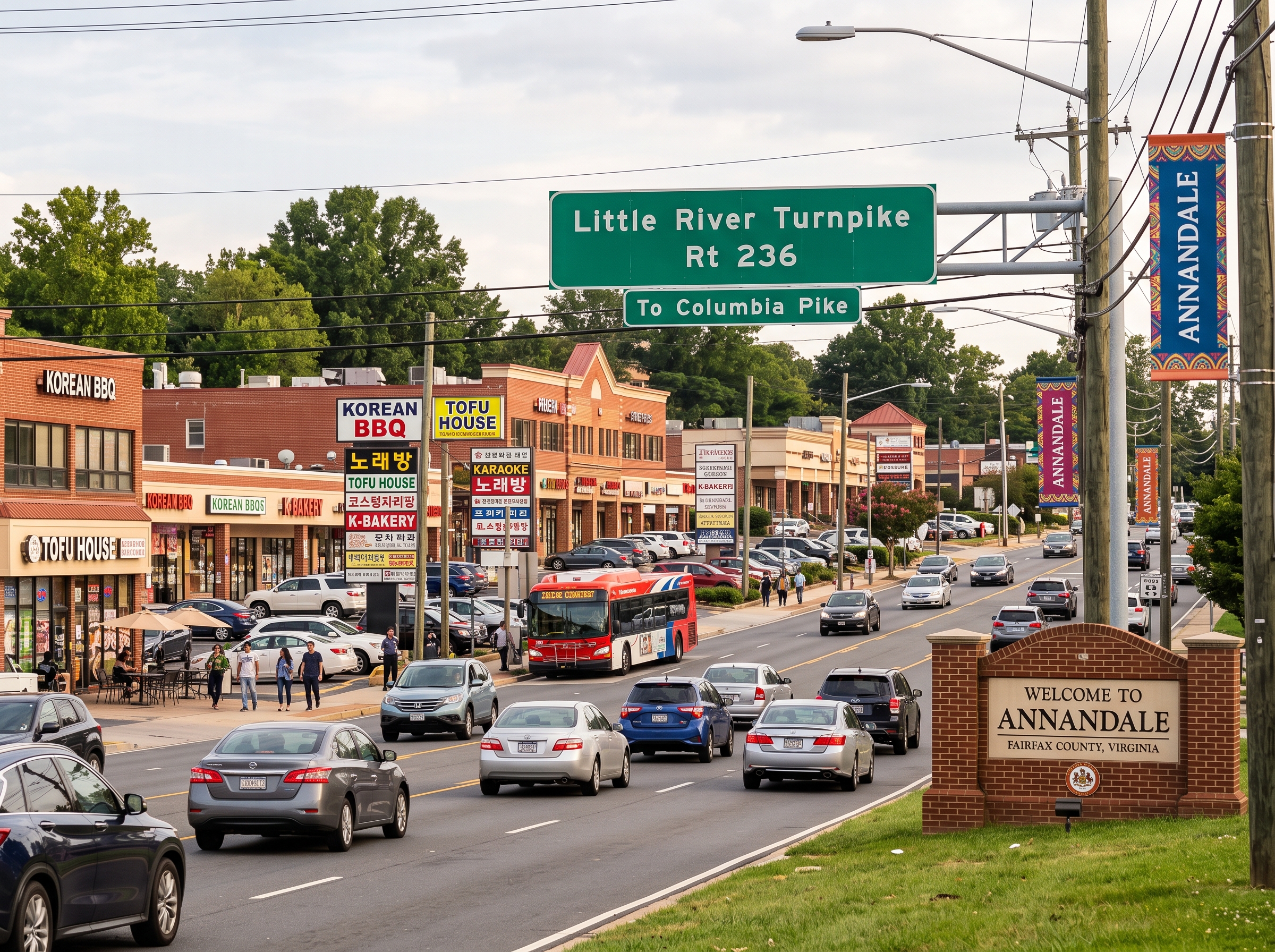
Architecturally and socio-economically, Annandale represents the historic heartland of Northern Virginia's mid-century suburban expansion. Developed predominantly between 1950 and 1975, its residential enclaves feature single-story brick ramblers, split-level floor plans, and celebrated architect-designed contemporary woodland communities situated on parcels frequently exceeding one-third to one-half acre. Positioned at the intersection of Little River Turnpike (Route 236) and Columbia Pike (Route 244), Annandale balances tranquil residential privacy with immediate access to a world-renowned international culinary and commercial core.
The Six Structural Pillars of Annandale Real Estate
- Strategic Multi-Directional Beltway Nexus. Positioned directly across the I-495 Capital Beltway corridor with dedicated access to the 495 Express Lanes, Little River Turnpike (Route 236), and Columbia Pike (Route 244), offering effortless radial commutes to Tysons, Alexandria, the Pentagon, and Washington, D.C.
- Mid-Century Architectural Heritage & Generous Lot Envelopes. Established subdivisions defined by solid masonry construction, expansive daylight basements, and substantial parcels averaging 0.30 to 0.60 acres, providing unparalleled infill flexibility and long-term land value.
- The Accotink Creek & Lake Accotink Environmental Spine. An extensive regional stream valley network encompassing hundreds of acres of contiguous parkland, wildlife sanctuaries, and the continuous Gerry Connolly Cross County Trail (CCT).
- Academic Rigor of the Annandale High School IB World Pyramid. High-caliber secondary education anchored by the internationally recognized International Baccalaureate (IB) Diploma Programme, accompanied by geographic proximity to Thomas Jefferson High School for Science and Technology (TJHSST).
- Cultural Dynamism & Commercial Vitality. A regionally celebrated culinary and commercial district concentrated along Little River Turnpike, bolstered by the county's active Annandale Commercial Revitalization District (CRD) framework.
- Fee-Simple Autonomy & Fiscal Efficiency. Predominantly non-HOA residential neighborhoods free from mandatory monthly association fees and restrictive private covenants, operating under a singular countywide real estate tax assessment structure.
2. Comprehensive Historical Evolution
The spatial morphology of Annandale reflects more than three centuries of American transformation, evolving from an aristocratic colonial patent into a historic turnpike outpost, an antebellum crossroads, and ultimately a post-World War II suburban vanguard for the federal civil service.
Colonial Origins & The Ravensworth Land Patent (1685)
The foundational land division governing modern Annandale dates to October 1685, when William Fitzhugh, an influential planter, attorney, and member of the Virginia House of Burgesses, obtained the vast Ravensworth Patent from the Northern Neck Proprietary. Spanning 24,196 acres across present-day central and southern Fairfax County, the patent encompassed virtually all of contemporary Annandale. Throughout the 18th century, the land operated under tenant leaseholds and agricultural plantations, shifting gradually from intensive tobacco cultivation to diversified grains, livestock, and timber harvesting as soil depletion altered colonial agrarian practices.
The Little River Turnpike & Scottish Naming (1806–1830)
Annandale's physical identity as a regional transit node solidified with the chartering of the Little River Turnpike in 1806. Financed as one of the earliest privately chartered paved toll turnpikes in the young United States, the macadamized thoroughfare connected the bustling deepwater Potomac River port of Alexandria with the agricultural fertile fields of Aldie and Middleburg in Loudoun County.
Where the turnpike intersected with ancient farm tracks—most notably the north-south alignment of Ravensworth Road and Columbia Pike—a vibrant commercial settlement took root. In 1830, Scottish-born physician Dr. William E. G. Black established a medical practice and apothecary at the crossroads, officially registering the settlement as "Annandale" in homage to the historic valley of the River Annan in Dumfriesshire, Scotland. A blacksmith shop, post office, tavern, and dry goods merchant quickly established Annandale as a pivotal stagecoach waystation.
Civil War Strife & The Annandale Chapel Outpost (1861–1865)
Due to its commanding position along the primary turnpike artery leading into the capital, Annandale became a contested borderland during the American Civil War. The Annandale Chapel (established in 1846 and now the historic core of Annandale United Methodist Church) served as an emergency military field hospital, quartermaster station, and fortified outpost.
Confederate cavalry units under General J.E.B. Stuart and the 43rd Battalion of Virginia Cavalry (Mosby's Rangers) frequently raided Union supply trains and picket stations along Little River Turnpike, targeting the defenses protecting Washington, D.C. Federal troops maintained continuous observation posts throughout Annandale, utilizing its elevated ridgelines to monitor troop maneuvers between Manassas and Alexandria.
The Post-War Suburban Vanguard: Broyhill & Cold War Expansion
Following the end of World War II and the explosive expansion of the federal bureaucracy in Washington, D.C., Annandale underwent the most rapid demographic transformation in its history. In the early 1950s, pioneering builder-developer M.T. Broyhill & Sons acquired hundreds of acres of rolling farmland, initiating construction on Broyhill Crest.
Broyhill introduced standardized, high-quality masonry construction techniques, erecting thousands of single-story brick ramblers and split-levels engineered specifically for returning veterans, intelligence personnel, and civil service families. By 1960, Annandale had transformed from a sleepy crossroads into the premier suburban bedroom community of Fairfax County, setting a gold standard for planned mid-century neighborhood development across the National Capital Region.
3. Physical Geography, Topography & Hydrology
Geologically situated within the crystalline upland of the Northern Virginia Piedmont physiographic province, Annandale rests upon rolling terrain with elevations varying from 240 feet above sea level along stream beds to approximately 380 feet on dominant ridgelines. The bedrock geology comprises Precambrian and early Paleozoic metamorphic rock formations—principally schist, gneiss, and metagraywacke—yielding well-drained, clay-loam soils characterized by strong structural bearing capacity.
The hydrology of Annandale is dominated by two primary drainage basins that flow south toward the Potomac River:
- The Accotink Creek Watershed: Flowing north-to-south through the western flank of Annandale, Accotink Creek forms an expansive natural drainage spine. It feeds directly into the 55-acre impoundment of Lake Accotink, creating continuous alluvial floodplains and steep wooded ravine topologies that naturally buffer adjacent residential subdivisions.
- The Indian Run Watershed: Traversing central and eastern Annandale, Indian Run and its seasonal tributaries drain through the parklands of Mason District Park, ultimately converging with Backlick Run and Cameron Run before discharging into the Potomac River at Alexandria.
Environmental regulation in Annandale is governed strictly by the Chesapeake Bay Preservation Act (CBPA), codified under Chapter 118 of the Fairfax County Code. Parcels bordering Accotink Creek, Indian Run, or designated perennial streams are encumbered by statutory 100-foot Resource Protection Area (RPA) vegetative buffer zones. Within an RPA, the clearing of mature woodland canopies, soil grading, and the erection of permanent structures (including home footprint expansions, retaining walls, detached garages, and inground swimming pools) are legally prohibited without formal water quality impact assessments and board-level environmental exceptions. Prospective purchasers of stream-adjacent real estate must exercise rigorous due diligence to delineate buildable lot envelopes from protected riparian buffers.
4. The Complete Annandale Neighborhood Dossier
Annandale is characterized by distinctive residential enclaves, each offering specific architectural profiles, parcel geometries, and community associations.
Broyhill Crest
Developed throughout the 1950s by the Broyhill Construction Company, Broyhill Crest encompasses over 1,200 single-family residences platted north of Little River Turnpike. The community stands as the quintessential mid-century suburban neighborhood, dominated by classic all-brick ramblers and side-to-side split-levels set upon uniform, maturely landscaped lots ranging from 0.25 to 0.35 acres. The community maintains an active voluntary civic association, a private community swimming club, and immediate walkability to Broyhill Crest Park.
Truro
Constructed between 1968 and 1974 by premier architectural builder Miller & Smith, Truro is recognized nationally as a triumph of contemporary woodland residential design. Comprising nearly 400 detached single-family homes, Truro is nestled within 37 acres of preserved communal parkland. The residences showcase striking modern California-contemporary architecture: dramatic vaulted ceilings with exposed timber beams, expansive clerestory windows, natural rough-sawn cedar cladding, and open floor plans designed to integrate seamlessly into the surrounding forest. The Truro Homes Association actively preserves neighborhood architectural harmony and maintains a community pool, tennis courts, and private nature trails.
Canterbury Woods & Wakefield Forest
Bordering the pristine stream valleys of Accotink Creek, Canterbury Woods and Wakefield Forest represent mid-century single-family enclaves prized for their tranquil woodland setting and generous parcel dimensions (0.35 to 0.55 acres). Featuring solid brick colonials, garrison multi-levels, and sprawling ranches, these neighborhoods are directly linked to the Gerry Connolly Cross County Trail and are served by the highly regarded Woodson High School academic pyramid.
Sleepy Hollow Woods & Sleepy Hollow
Located in northeastern Annandale near the Falls Church border, Sleepy Hollow Woods offers a picturesque rolling topography and expansive, densely wooded lots often exceeding a half-acre. Constructed in the late 1950s and 1960s, the homes include custom ramblers, tri-level colonials, and contemporary mid-century structures. The neighborhood enjoys exceptional proximity to Route 7 and Seven Corners, providing convenient routes into Arlington and Washington, D.C.
Camelot & Pine Ridge
Situated immediately west of the Capital Beltway off Gallows Road, Camelot is an established enclave of classic 1960s split-levels and two-story brick colonials. Famous for its vibrant community spirit, active neighborhood swim club (Camelot Community Club), and festive seasonal traditions, Camelot attracts purchasers seeking fee-simple living within five minutes of the Inova Fairfax Hospital medical campus and the Dunn Loring Metrorail station.
Ravensworth Farm
Positioned in southern Annandale adjacent to the historic Fitzhugh estate lands, Ravensworth Farm encompasses over 800 single-family residences developed throughout the 1960s. Dominated by brick split-foyer and split-level homes on flat, usable lots, the neighborhood borders Lake Accotink Park, offering residents immediate walking access to sailing, fishing, and regional running trails.
5. Architectural Typologies
Annandale's residential housing inventory provides an authentic physical catalog of post-war American architectural evolution:
- Classic Red Brick Ramblers (1950–1962): The architectural foundation of Annandale. These single-story homes feature solid masonry structural walls, low-pitch gable or hip rooflines, deep eaves, large picture windows, and full lower-level daylight basements that effectively double the usable floor area. Highly prized today for their single-level accessibility and structural adaptability for open-concept interior remodeling.
- Split-Level & Split-Foyer Designs (1958–1975): Ingeniously engineered to accommodate the rolling topography of Northern Virginia, these residences utilize staggered floor levels to delineate public entertaining spaces from private bedroom suites and ground-level family recreational rooms. They feature efficient spatial footprints and integrated one- or two-car garages.
- Mid-Century Contemporary Post-and-Beam (1968–1975): Epitomized by Truro, these custom homes showcase soaring cathedral ceilings, tongue-and-groove cedar decking, expansive floor-to-ceiling glass fenestration, wrap-around cantilevered decks, and direct sightlines into preserved woodland settings.
- Colonial Revival Two-Story Residences (1962–1980): Featuring formal symmetrical center-hall layouts, brick veneers, six-over-six double-hung sash windows, crown moldings, formal dining rooms, and brick masonry fireplaces.
- 21st-Century Custom Infill Craftsman & Modern Farmhouses: Capitalizing on Annandale's generous lot footprints, custom luxury builders selectively acquire older ramblers to construct substantial two- and three-story luxury residences featuring hardie-plank and stone facades, open-concept floor plans, gourmet culinary kitchens, and three-car garages.
6. Municipal Zoning & Infill Land-Use Framework
Land use and residential development across Annandale are governed exclusively by the Fairfax County Zoning Ordinance (zMOD), adopted to modernize and streamline residential and commercial property regulations.
Residential Zoning Classifications
The overwhelming majority of Annandale's residential subdivisions fall within three standard single-family residential districts:
- R-2 District (Residential, Two Units/Acre): Characterizes large-lot enclaves such as Sleepy Hollow and portions of western Annandale. Mandates a minimum lot size of 20,000 square feet, a minimum lot width of 100 feet, front setbacks of 35 feet, and combined side yard setbacks of 25 feet.
- R-3 District (Residential, Three Units/Acre): The dominant zoning designation for mid-century neighborhoods including Broyhill Crest and Camelot. Requires a minimum lot size of 10,500 square feet, a minimum lot width of 80 feet, front yard setbacks of 30 feet, and a maximum building height of 35 feet.
- R-4 District (Residential, Four Units/Acre): Applied to higher-density subdivisions and cluster developments, requiring a minimum lot area of 8,400 square feet with a minimum lot width of 70 feet.
The Annandale Commercial Revitalization District (CRD)
Designated by the Fairfax County Board of Supervisors, the Annandale Commercial Revitalization District (CRD) encompasses the central commercial core along Little River Turnpike and Columbia Pike. The CRD overlay is designed to encourage mixed-use redevelopment, pedestrian-oriented streetscapes, consolidated access points, and quality urban design. It grants flexible Floor Area Ratios (FAR) and reduced parking minimums for qualifying mixed-use residential and commercial developments, driving long-term civic vitality while safeguarding adjacent single-family residential buffers.
7. Educational Ecosystem & School Pyramids
Annandale's public education is administered by Fairfax County Public Schools (FCPS), consistently recognized as one of the preeminent public school systems in the United States. Residential properties in Annandale are mapped into high-performing academic pyramids defined by specialized curricula and collegiate preparation.
The Annandale High School International Baccalaureate (IB) Pyramid
The civic centerpiece of the community is Annandale High School, situated on Four Penny Drive. Annandale High is an authorized International Baccalaureate (IB) World School offering the comprehensive IB Diploma Programme. The curriculum emphasizes international perspective, interdisciplinary synthesis, advanced foreign language acquisition, and a 4,000-word independent research Extended Essay. The high school boasts award-winning fine arts programs, competitive athletic programs in the Virginia High School League (VHSL) Class 6, and dedicated academic support academies.
The secondary school is fed by Edgar Allan Poe Middle School, which administers the IB Middle Years Programme (MYP) for grades 6 through 8. Feeder elementary institutions include Columbia Elementary, Annandale Terrace Elementary, Braddock Elementary, and Weyanoke Elementary.
The W.T. Woodson & Falls Church High School Feeder Pockets
Depending on specific residential boundaries, select Annandale neighborhoods feed into neighboring elite FCPS high school pyramids:
- The W.T. Woodson Pyramid: Neighborhoods in western and southern Annandale—including Canterbury Woods and Truro—feed into Canterbury Woods Elementary (an established FCPS Advanced Academic Programs [AAP] Level IV Center), Frost Middle School, and W.T. Woodson High School, celebrated for its Advanced Placement (AP) curricula and academic distinctions.
- The Falls Church High School Pyramid: Residential streets in northern Annandale feed into Luther Jackson Middle School and Falls Church High School, offering specialized STEM academies and rigorous AP programs.
Additionally, all qualified Annandale secondary students are eligible to apply through competitive regional screening to the prestigious Thomas Jefferson High School for Science and Technology (TJHSST). Ranked consistently among the top public high schools in the nation, TJHSST is located physically on Braddock Road within the borders of Annandale, providing neighborhood students with immediate geographic proximity to its state-of-the-art research laboratories and advanced STEM mentorships.
8. Multi-Modal Commuting & Regional Arterials
Annandale's geographic positioning provides an exceptional commuting advantage within the National Capital Region, featuring multi-layered arterial, highway, and bus transit networks.
- Interstate 495 (Capital Beltway): Slicing directly through Annandale, I-495 features strategic local interchanges at Little River Turnpike (Route 236), Braddock Road, and Route 50. Residents enjoy direct entry to the 495 Express Lanes, enabling reliable, variable-toll express commutes north to Tysons Corner and the Dulles Technology Corridor, or south to Old Town Alexandria and National Harbor.
- Little River Turnpike (Route 236): The historic east-west arterial linking the City of Fairfax directly to Alexandria. It intersects I-395 at the Duke Street junction, delivering a direct 15-minute commute to the Pentagon and Arlington employment centers.
- Columbia Pike (Route 244): Originating in Annandale, Columbia Pike provides an unobstructed surface arterial route through Bailey's Crossroads, Barcroft, and the Pentagon City / National Landing commercial corridor.
- Public Bus Transit Networks: The Washington Metropolitan Area Transit Authority (WMATA) operates frequent Metrobus service along Route 236 and Route 244, offering direct one-seat express connections to the Pentagon Transit Concourse. Fairfax Connector routes link residential subdivisions to Metrorail stations.
- Heavy-Rail Metrorail Stations: While Annandale does not contain a train platform within its borders, it is encircled by heavy-rail stations within an 8- to 12-minute drive: Dunn Loring-Merrifield (Orange Line), East Falls Church (Orange/Silver Lines), and Franconia-Springfield (Blue Line).
- The Gerry Connolly Cross County Trail (CCT): A 40-mile contiguous multi-use trail network passing through Lake Accotink and the Accotink Creek stream valley, functioning as a non-motorized bicycle commuting spine.
9. Parks, Community Life & Civic Institutions
Annandale residents benefit from one of the densest and most diverse municipal and regional parkland infrastructures in Northern Virginia.
Mason District Park
Spanning 121 acres off Columbia Pike, Mason District Park serves as the civic and cultural heart of eastern Annandale. The park features an illuminated athletic complex with synthetic-turf football/soccer fields, baseball diamonds, six tennis courts, basketball courts, and a fenced dog exercise area. Its centerpiece is the covered outdoor Newton Edwards Amphitheater, which hosts the free summer "Spotlight by Starlight" multicultural concert series, theatrical productions, and civic ceremonies. The park also hosts an official seasonal Fairfax County Farmers Market offering fresh local produce, baked goods, and native plants.
Wakefield Park & The Audrey Moore RECenter
Covering 290 acres along Braddock Road adjacent to the Beltway, Wakefield Park is an elite recreational complex. It houses the Audrey Moore RECenter, a premier county facility featuring an indoor Olympic-sized 50-meter swimming pool, therapy pool, modern cardiovascular and strength-training fitness centers, squash/racquetball courts, and a full-size gymnasium. Outdoors, the park provides lighted tennis and pickleball complexes, synthetic-turf athletic fields, a specialized public skate park, and direct trailheads into the Cross County Trail.
Hidden Oaks Nature Center
Tucked within 52 acres of native oak and hickory woodland at Annandale Community Park, Hidden Oaks Nature Center provides family-focused environmental stewardship. It features interactive indoor natural history exhibits, live reptile and amphibian habitats, the "Nature Playce" outdoor exploration space, and paved ADA-accessible nature trails winding through the Indian Run stream valley.
Lake Accotink Park
Encompassing 493 protected acres on the southwestern border of Annandale, Lake Accotink Park surrounds a scenic 55-acre freshwater lake. Residents enjoy private kayak, canoe, and pedal-boat rentals, a historic antique carousel, shaded picnic pavilions, a 3.7-mile continuous loop trail, and prime freshwater fishing.
10. Fiscal Architecture, Taxation & HOA Nuances
Real estate ownership in Annandale is governed by the statutory framework of the Commonwealth of Virginia and Fairfax County fiscal policy.
Virginia Code Title 58.1 & Annual Fair Market Assessment
In accordance with Virginia Code Title 58.1, all real property in Annandale is assessed annually at 100 percent of fair market value by the Fairfax County Department of Tax Administration (DTA). The assessment evaluates historical arms-length sales transactions, building permit improvements, depreciation tables, and neighborhood equalization metrics.
The Unincorporated Tax Advantage
Because Annandale is an unincorporated community rather than an independent city (such as Falls Church or Fairfax) or an incorporated town (such as Vienna or Herndon), property owners pay a single unified real estate tax bill to Fairfax County. Homeowners are not subject to a secondary municipal real estate levy, resulting in a significantly lower overall statutory tax burden while retaining full access to county fire, rescue, emergency response, and public school infrastructure. Property tax bills also incorporate the dedicated countywide Stormwater Service District levy to maintain regional drainage infrastructure.
HOA Governance vs. Fee-Simple Independence
One of the primary structural attractions of Annandale is the widespread prevalence of fee-simple non-HOA homeownership. Across Broyhill Crest, Sleepy Hollow Woods, Camelot, and Wakefield Forest, homeowners are not bound by mandatory monthly association assessments, private architectural review boards, or corporate bylaws. Property rights and improvements are regulated solely by Fairfax County building codes and zoning ordinances.
Conversely, master-planned contemporary enclaves like Truro operate under legally binding covenants administered by the Truro Homes Association. These covenants regulate exterior paint selections, roof materials, window designs, tree removal, and additions, safeguarding the distinct mid-century architectural integrity that underpins the neighborhood's enduring market equity.
11. Strategic Buyer Guidance
Purchasing residential real estate in an established mid-century community like Annandale necessitates structured, specialized due diligence:
- Basement Moisture & Hydrostatic Pressure Due Diligence: Most homes constructed in the 1950s and 1960s were built with concrete block (cinder block) foundation walls rather than modern poured concrete. Prospective buyers should inspect foundation perimeters for step cracking, efflorescence, and water penetration. Evaluating exterior grade slopes, gutter downspout extensions, and sub-slab perimeter drain tile / sump pump systems is essential.
- Underground Utilities & Infrastructure Age: Buyers should conduct video camera sewer scope inspections of main lateral lines running from the home foundation to the municipal main in the street. Original mid-century cast iron or terra-cotta clay pipes may experience root intrusion, channel rotting, or separation. Additionally, incoming copper vs. galvanized water supply lines must be evaluated.
- Riparian Buffers & Resource Protection Areas (RPAs): When purchasing parcels bordering Accotink Creek, Indian Run, or seasonal drainage channels, verify county GIS environmental overlay maps. The presence of a 100-foot RPA boundary legally restricts future rear yard improvements, including swimming pools, large patios, and structural additions.
- Electrical Service Capacity: Many original 1950s ramblers were wired with 60-amp or 100-amp electrical panels. Modern residential demands—including heat pumps, induction cooking, Level 2 electric vehicle (EV) charging stations, and finished basements—typically necessitate a service upgrade to a 200-amp panel.
12. Strategic Seller Guidance
Homeowners preparing to market a property in Annandale should leverage the unique structural advantages inherent in mature submarkets:
- Emphasize Generous Lot Proportions & Expansion Potential: Annandale's lot sizes (frequently 0.35 to 0.55 acres) represent substantial underlying land equity. Sellers should highlight deep rear yards, mature hardwood canopies, and outdoor living potential compared to newer high-density developments in neighboring jurisdictions.
- Celebrate Mid-Century Architectural Character: Whether a classic brick rambler or a contemporary timber home in Truro, marketing should accentuate mid-century aesthetics: refinished original white oak hardwoods, clean geometric sightlines, large picture windows, daylight lower levels, and mid-century modern design elements.
- Pre-Sale System Certifications: Given the vintage of the housing stock, savvy sellers eliminate buyer hesitation by obtaining pre-listing structural, chimney, and HVAC inspections. Providing clean documentation of roof lifespans, electrical panel upgrades, and waterproofed basements commands immediate market liquidity and multiple offers.
- Promote Multi-Modal Commute Efficiencies: Marketing collateral should detail exact door-to-door transit times to the Pentagon, Tysons, and central Washington, D.C., emphasizing the rare flexibility of choosing between I-495, surface turnpikes, or express bus lines.
13. Submarket Comparative Matrix
To understand Annandale's unique positioning within the regional housing landscape, the following matrix compares key Northern Virginia suburban submarkets:
| Submarket | Governance Structure | Dominant Architectural Typologies | Typical Lot Dimensions | Transit & Highway Access | HOA Prevalence |
|---|---|---|---|---|---|
| Annandale | Unincorporated Fairfax County (Mason/Braddock Districts) | Mid-Century Brick Ramblers, Split-Levels, Contemporary Post-and-Beam, Infill Craftsman | 0.28 to 0.55 Acres | Direct I-495 Beltway, Express Lanes, Rt 236, Rt 244, Express Bus to Pentagon | Predominantly Non-HOA (Fee-Simple); Selective Covenants (Truro) |
| Springfield | Unincorporated Fairfax County (Franconia/Lee Districts) | 1960s Split-Levels, Colonials, Townhome Enclaves | 0.20 to 0.35 Acres | I-95/I-395/I-495 "Mixing Bowl" Interchange, Franconia-Springfield Metro/VRE | Mix of Non-HOA and Mandatory Planned Associations |
| Falls Church (County) | Unincorporated Fairfax County (Mason/Providence Districts) | Mid-Century Ranches, Cape Cods, Infill Transitional Luxury | 0.22 to 0.38 Acres | Route 7 (Leesburg Pike), Route 50 (Arlington Blvd), Proximity to East Falls Church Metro | Predominantly Non-HOA |
| Town of Vienna | Incorporated Municipality within Fairfax County | Historic Victorians, Modest Ramblers, Substantial Custom Infill Estates | 0.20 to 0.35 Acres | Route 123 (Maple Ave), I-66, Vienna Metrorail, W&OD Trail | Municipal Town Zoning, Strict ARB; Supplemental Town Tax |
| City of Fairfax | Independent Incorporated City (Autonomous Jurisdiction) | Mid-Century Ranches, Brick Colonials, Modern Townhome Clusters | 0.25 to 0.40 Acres | Route 29/50/236 Confluence, CUE Bus System, Vienna Metro Access | Independent City Government, City Police & Schools |
14. 10 Comprehensive Evergreen FAQs
1. Is Annandale an incorporated municipality or governed by Fairfax County?
Annandale is an unincorporated census-designated place (CDP) governed directly by the Fairfax County Board of Supervisors, divided across the Mason and Braddock Magisterial Districts. Because it is not an incorporated town, residential properties in Annandale are not subject to secondary municipal real estate taxes, separate town council ordinances, or municipal police departments. All municipal services—including law enforcement (Fairfax County Police Department Mason and West Springfield Stations), public education, emergency response, and land-use zoning—are administered by Fairfax County.
2. How did Annandale get its name and historic identity?
Annandale's origins trace to the historic Ravensworth land patent of 1685 granted to William Fitzhugh. In 1830, Scottish physician Dr. William E. G. Black officially bestowed the name "Annandale" upon the community after the valley of the River Annan in Dumfriesshire, Scotland. The crossroads prospered following the 1806 charter of the Little River Turnpike, serving as a primary agricultural toll route linking the western Virginia piedmont to the Potomac River port of Alexandria.
3. What architectural home styles dominate Annandale’s residential neighborhoods?
Annandale is renowned as Northern Virginia's heartland for authentic mid-century residential architecture. The housing stock features single-story red brick ramblers and ranches built primarily between 1950 and 1965 on full basements, split-level and bi-level homes, architect-designed mid-century modern contemporary residences with exposed timber beams and vaulted glass (exemplified by Truro), traditional two-story colonial revivals, and 21st-century luxury craftsman infill estates on generous half-acre parcels.
4. How does the International Baccalaureate (IB) program function at Annandale High School?
Annandale High School is an authorized International Baccalaureate (IB) World School within Fairfax County Public Schools (FCPS) Region 2. The IB Diploma Programme provides rigorous pre-university curriculum focusing on advanced critical thinking, interdisciplinary inquiry, world languages, community service, and global perspectives. Students can pursue the full IB Diploma or individual IB course certificates, earning advanced collegiate course credits while participating in specialized collegiate preparatory pathways.
5. How does the Chesapeake Bay Preservation Act impact property modifications in Annandale?
Under the Chesapeake Bay Preservation Act and Fairfax County environmental ordinances, properties situated along the Accotink Creek, Indian Run, and tributary drainages are governed by mandatory 100-foot Resource Protection Area (RPA) vegetative buffer corridors. Within an RPA, the clearing of mature trees, grading, and the erection of impermeable structures (such as home additions, detached garages, or swimming pools) are strictly regulated, requiring formal water quality impact assessments and county environmental exceptions.
6. What public transit options connect Annandale to Washington, D.C. and the Pentagon?
Annandale features robust multi-modal transit options. The Washington Metropolitan Area Transit Authority (WMATA) operates high-frequency Metrobus lines along Little River Turnpike (Route 236) and Columbia Pike (Route 244), delivering direct one-seat commuter transit to the Pentagon transit concourse and Washington, D.C. Additionally, Fairfax Connector routes link residential subdivisions directly to nearby Metrorail stations, including Dunn Loring-Merrifield on the Orange Line and Franconia-Springfield on the Blue Line.
7. Do most neighborhoods in Annandale have mandatory Homeowners Associations (HOAs)?
The vast majority of mature detached single-family subdivisions in Annandale—including Broyhill Crest, Sleepy Hollow Woods, Camelot, and Pine Ridge—are entirely non-HOA fee-simple communities, freeing homeowners from mandatory monthly dues and restrictive architectural review boards. However, notable planned communities like Truro operate active community associations that maintain neighborhood swimming pools, tennis facilities, and enforce architectural preservation covenants designed to safeguard original contemporary mid-century designs.
8. What is the significance of the Truro neighborhood in American residential architecture?
Truro is celebrated among architectural historians as one of the Mid-Atlantic's most successful master-planned mid-century contemporary woodland communities. Developed in the late 1960s and early 1970s by Miller & Smith, Truro features custom timber-and-glass homes that harmonize with the native rolling Piedmont forest. The residences showcase post-and-beam construction, expansive clerestory fenestration, cedar siding, and open interior volumes, preserved through strict community design standards.
9. How are real estate taxes assessed for property owners in Annandale?
Real estate taxation in Annandale is governed by Virginia Code Title 58.1, which mandates annual assessment of real property at 100 percent of fair market value by the Fairfax County Department of Tax Administration. Homeowners pay the Fairfax County base real estate levy and countywide stormwater service district assessments. Because Annandale is unincorporated, residents benefit from paying only one single county assessment, avoiding the supplemental municipal tax rates incurred by residents of incorporated towns.
10. What recreational amenities are offered by Mason District Park and Wakefield Park?
Mason District Park spans 121 acres and features a dedicated covered amphitheater hosting popular summer cultural concerts, illuminated athletic fields, tennis courts, native woodland trails, a dog park, and an official Fairfax County farmers market. Wakefield Park encompasses 290 acres and houses the Audrey Moore RECenter—a flagship indoor recreational facility featuring an Olympic-sized indoor swimming pool, fitness center, gymnasium, and outdoor tennis, pickleball, and skate parks linked directly to the Gerry Connolly Cross County Trail.
15. Legal & Fair Housing Disclaimer
This real estate and community monograph is published strictly for informational, educational, and demographic research purposes. While all data is derived from official Fairfax County public records, the Virginia General Assembly Code, and regional municipal archives, boundaries, zoning classifications, environmental overlays, tax assessments, and school attendance pyramids are subject to periodic governmental amendment. Prospective purchasers, sellers, and investors are strongly advised to verify specific parcel zoning classifications, Resource Protection Area (RPA) delineations, and title encumbrances through the Fairfax County Department of Land Development Services (LDS), the Department of Tax Administration (DTA), and licensed land survey professionals prior to executing binding legal contracts. This publication strictly adheres to all provisions of Title VIII of the Civil Rights Act of 1968 (The Federal Fair Housing Act) and the Virginia Fair Housing Law, prohibiting discrimination on the basis of race, color, religion, sex, handicap, familial status, elderliness, or national origin.