
Fort Hunt, VA Real Estate: The Definitive Guide to Spatial Morphology, River Farm Heritage, Fort Hunt Park & Potomac River Communities
Executive Summary & Essential Community Takeaways
- Historic Potomac River Corridor: Fort Hunt is an unincorporated census-designated place (CDP) in Fairfax County's Mount Vernon Magisterial District (ZIP code 22308), occupying the historic lands of George Washington's original River Farm plantation along the tidal Potomac River.
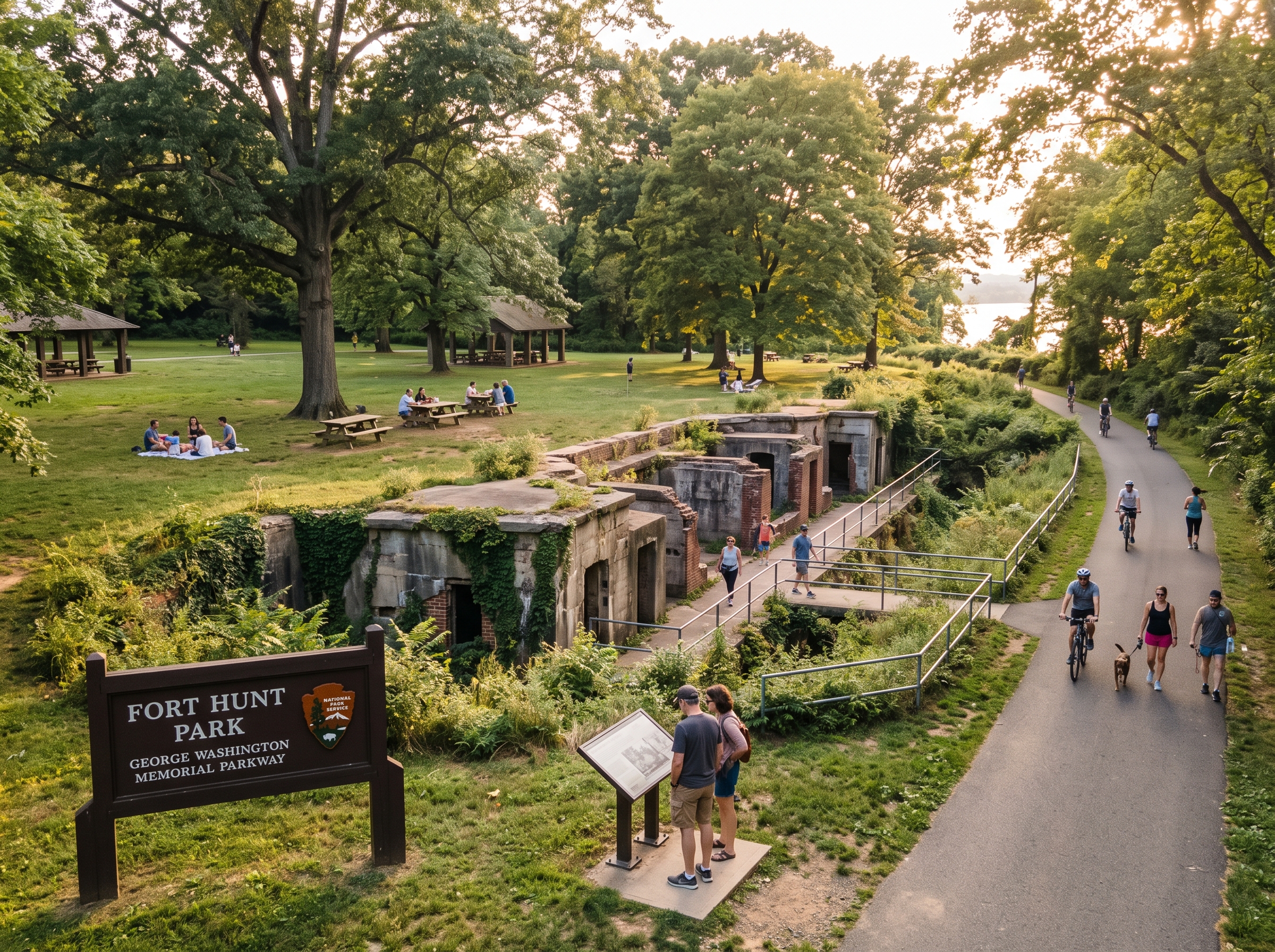
- 157-Acre Fort Hunt Park (NPS): A premier national parkland featuring preserved Endicott-era coastal artillery fortifications (such as Battery Mount Vernon), the secret World War II military intelligence history of "P.O. Box 1142," expansive picnic pavilions, athletic fields, and direct connection to the paved 18-mile Mount Vernon Trail.
- Distinguished Post-War & Mid-Century Architecture: Celebrated for cohesive, master-planned residential enclaves including Waynewood (winner of national architectural acclaim for its community design), Villamay (famed for custom mid-century modern split-levels with expansive window walls), Stratford Landing, and Hollin Hall Village.
- River Farm & American Horticultural Society: Anchored by the 25-acre River Farm estate—George Washington's former agricultural holding, now serving as the national headquarters of the American Horticultural Society with public botanical display gardens and riverfront event grounds.
- Premier FCPS Academic Feeder Pyramid: Zoned to Fairfax County Public Schools within the West Potomac High School pyramid (offering the AP Capstone Diploma and West Potomac Academy), Carl Sandburg Middle School (a Full-Time AAP Level IV Center), and award-winning elementary schools including Waynewood Elementary (a National Blue Ribbon School).
- Virginia Statutory Assessment Standards: Real property is evaluated under Virginia Code § 58.1-3201 at 100 percent of fair market value by the Fairfax County Department of Tax Administration (DTA), with semi-annual tax installments due on July 28 and December 5.
1. Spatial Morphology, Boundaries & Regional Geography
Fort Hunt represents one of Northern Virginia's most cohesive, geographically sheltered suburban enclaves. Situated in the southeastern quadrant of Fairfax County within the Mount Vernon Magisterial District (postal ZIP code 22308), the community encompasses approximately six square miles along the western bluffs of the tidal Potomac River.
The spatial perimeter of Fort Hunt is delineated by river shorelines, historic estate boundaries, and major transportation corridors:
- East & South Boundary: The tidal shoreline of the Potomac River and the federally protected George Washington Memorial Parkway corridor, providing unobstructed water vistas and public parkland buffers.
- West Boundary: Fort Hunt Road (State Route 629) and the tidal ravines of Little Hunting Creek, separating Fort Hunt from the Richmond Highway (Route 1) commercial corridor and Hybla Valley.
- North Boundary: Belle Haven, New Alexandria, and the Dyke Marsh Wildlife Preserve along Hunting Creek.
- Southwest Boundary: George Washington's historic Mount Vernon estate and the scenic waterfront mouth of Little Hunting Creek.
2. Historical Evolution: George Washington's River Farm, Coastal Fortifications & Post-War Suburban Design
The land comprising Fort Hunt holds deep roots in colonial agriculture, early American military defense, and post-war suburban planning.
George Washington's River Farm Plantation (1760–1890)
In 1760, George Washington acquired a 1,800-acre agricultural tract along the Potomac River, designating it as River Farm—one of the five working agricultural divisions of the broader Mount Vernon estate. Washington managed the plantation with innovative crop rotations, testing wheat, clover, and flax while planting walnut groves and orchards. Following Washington's death, the land was willed to his family and subsequently divided into smaller pastoral holdings.
Fort Hunt & Coastal Artillery Defense (1893–1945)
In 1893, responding to the recommendations of the Endicott Board to modernize American coastal defenses, the federal government acquired a strategic riverfront bluff from the River Farm tract to construct modern coastal artillery fortifications. The post was named Fort Hunt in honor of Major General Henry Jackson Hunt, a distinguished Union artillery commander celebrated for his role at the Battle of Gettysburg.
Engineers erected massive reinforced-concrete batteries—including Battery Mount Vernon, Battery Robinson, Battery Sater, and Battery Porter—housing rapid-fire coastal defense guns, observation towers, and submarine mine storage to defend the Potomac water approach to the nation's capital during the Spanish-American War.
During World War II, Fort Hunt played a pivotal, clandestine role as the site of P.O. Box 1142, a top-secret military intelligence facility where high-ranking captured German military officers, scientists (including rocket scientists), and submariners were covertly interrogated, and critical intelligence operations supporting Allied victory were coordinated. Following the war in 1948, the reservation was transferred to the National Park Service.
Post-WWII Master-Planned Suburban Communities (1950–1975)
In the 1950s, visionary builders transformed the former agricultural and equestrian holdings of Fort Hunt into celebrated residential communities. Developer Clarence W. Gosnell platted Waynewood, integrating wide, curvilinear parkways, dedicated park belts, and a central community pool and elementary school.
Simultaneously, architect Nicholas Satterlee and builder Eugene Hurley developed Villamay, introducing custom mid-century modern split-level architecture that gained national recognition for its sensitivity to natural topography and river views.
3. Residential Enclaves, Neighborhood Typologies & Architectural Morphology
Fort Hunt features one of the most cohesive collections of mid-century single-family neighborhoods in the Washington metropolitan region, complemented by custom waterfront estates and sensitive modern infill.
| Residential Subdivision / Enclave | Primary Architectural Style | Construction Era | Typical Lot Dimensions | Fairfax County Zoning |
|---|---|---|---|---|
| Waynewood | Brick Split-Levels, Ramblers, Two-Story Colonials | 1957 – 1968 | 0.25 to 0.35 Acre Parcels | R-3 (Single-Family Residential) |
| Villamay | Mid-Century Modern Custom Split-Levels | 1958 – 1968 | 0.30 to 0.50 Acre Terraced Lots | R-2 / R-3 (Low-Density Residential) |
| Stratford Landing | Brick Ramblers, Split-Levels, Colonials | 1956 – 1970 | 0.25 to 0.38 Acre Wooded Lots | R-3 (Suburban Single-Family) |
| Riverside Gardens | Split-Foyer, Split-Level, Colonial | 1962 – 1975 | 0.28 to 0.40 Acre Parcels | R-3 (Single-Family Residential) |
| Hollin Hall Village | Post-War Brick Starter Cottages, Ramblers, Pop-Tops | 1948 – 1958 | 0.20 to 0.30 Acre Lots | R-4 (Medium-Density Single-Family) |
| Plymouth Haven & River Bluff Estates | Custom Waterfront Mansions & Modern Infill | 1960 – Present | 0.45 to 1.00+ Acre Waterfront Lots | R-2 / R-1 (Low-Density Estate) |
Waynewood: The Gold Standard of Post-War Community Planning
Developed by Clarence W. Gosnell between 1957 and 1968, Waynewood is widely recognized as a triumph of post-war suburban design. The community was planned with underground utilities (rare for its era), wide tree-lined residential parkways, mature native oak canopies, and no commercial cut-throughs. Homes feature authentic red-brick construction, multi-level split-level designs, deep rear gardens, and direct pedestrian sidewalks linking homes to the Waynewood Recreation Association pool and the nationally recognized Waynewood Elementary School.
Villamay: Acclaimed Mid-Century Modern Architecture
Perched on elevated, terraced ridges with sweeping vistas toward the Potomac River, Villamay was designed by architect Nicholas Satterlee. Homes in Villamay are celebrated for:
- Low-pitched gabled rooflines with deep overhangs and exposed tongue-and-groove cedar soffits.
- Expansive floor-to-ceiling horizontal window banks that integrate indoor living spaces with private wooded rear terraces.
- Prominent natural river-rock and fieldstone fireplace chimneys anchoring vaulted living rooms.
- Thoughtful multi-tier floor plans that follow the natural slope of the rolling topography without extensive earth grading.
Stratford Landing & Riverside Gardens
Bordering Little Hunting Creek and the Potomac parklands, Stratford Landing and Riverside Gardens provide traditional post-war suburban charm. Both neighborhoods are anchored by their own member-owned swim and tennis clubs, offering multi-generational recreation, competitive swim leagues, and annual community social gatherings.
River Bluff & Custom Modern Infill
Along the riverfront bluffs overlooking the George Washington Memorial Parkway and the Potomac, luxury custom builders have constructed bespoke modern infill estates. Ranging from 5,000 to over 8,000 square feet, these homes feature open-concept floor plans, gourmet catering kitchens, multiple primary suites with waterfront balconies, and high-performance building envelopes.
4. Structural Anatomy, Building Eras & Technical Due Diligence
Evaluating residential properties in Fort Hunt requires specialized knowledge of mid-century building systems and coastal plain environmental conditions:
Mid-Century Masonry Residences (1950–1975)
- Foundations & Soil Mechanics: Homes typically feature poured concrete or concrete masonry unit (CMU) crawl space and basement foundations. Situated within the coastal plain geological formation, properties near stream valleys must maintain positive perimeter grading slope (a minimum 5 percent drop away from foundation walls for 10 feet) and functional gutter downspout extensions to prevent hydrostatic water penetration.
- Plumbing Supply & Cast Iron DWV: Water supply is delivered via Type L copper piping. Original drain-waste-vent (DWV) piping utilized heavy cast iron stacks. Homebuyers should commission a fiber-optic video camera sewer scope inspection of the sewer lateral from the cleanout to the street main to check for interior rust scaling, pipe settlement, or tree root penetration from mature oak and maple trees.
- Electrical Service Infrastructure: Original installations often featured 60-amp or 100-amp split-bus electrical panels. Modern lifestyles require upgrading to a 200-amp circuit breaker panel with arc-fault (AFCI) and ground-fault (GFCI) protection to safely support modern HVAC heat pumps and electric vehicle charging equipment.
- Attic Ventilation & Roof Assemblies: Built with dimensional 2x6 rafters or early pre-engineered roof trusses sheathed with 1x6 tongue-and-groove boards or plywood. Ensuring balanced attic airflow through continuous soffit intake vents and ridge exhaust vents prevents winter ice damming and extends asphalt shingle lifespan.
Chesapeake Bay RPA Regulations
Properties bordering the Potomac River, Little Hunting Creek, or tributary drainage swales are subject to the Fairfax County Chesapeake Bay Preservation Ordinance. Building additions, pool installations, or significant land disturbances within the designated 100-foot Resource Protection Area (RPA) buffer require county review, water quality impact assessments, and native mitigation plantings.
5. Public Education Infrastructure: FCPS School Pyramids & Academic Profiles
Fort Hunt is served exclusively by Fairfax County Public Schools (FCPS), recognized nationally for academic excellence. The community feeds directly into the West Potomac High School Pyramid, distinguished by exceptional academic achievements, specialized career academies, and strong civic support.
| School Facility | Grade Levels | Feeder Alignment | Curriculum Programs & Academic Distinctions |
|---|---|---|---|
| West Potomac High School | Grades 9 – 12 | West Potomac Pyramid | AP Capstone Diploma, West Potomac Academy (Health Sciences & Communications), Championship Performing Arts |
| Carl Sandburg Middle School | Grades 7 – 8 | West Potomac Pyramid | Full-Time Advanced Academic Programs (AAP Level IV Center), Accelerated Math & STEM Labs |
| Waynewood Elementary School | Pre-K – Grade 6 | West Potomac Pyramid | National Blue Ribbon School of Excellence, Advanced Academic Programs (AAP), Math Olympiad |
| Stratford Landing Elementary School | Pre-K – Grade 6 | West Potomac Pyramid | Advanced Academic Programs (AAP), Eco-Schools USA Green Flag Award, Responsive Classroom |
| Fort Hunt Elementary School | Pre-K – Grade 6 | West Potomac Pyramid | Spanish Partial Dual-Language Immersion, Advanced Academic Programs (AAP), STEAM Labs |
| Hollin Meadows Elementary School | Pre-K – Grade 6 | West Potomac Pyramid | Outdoor Learning Math and Science Garden Lab, Advanced Academic Programs (AAP) |
West Potomac High School & The AP Capstone Program
West Potomac High School delivers a rigorous collegiate-prep curriculum featuring the AP Capstone Diploma program. Students engage in intensive, research-driven seminars in AP Seminar and AP Research, authoring independent academic theses. Furthermore, the campus hosts the West Potomac Academy, providing specialized professional career coursework in biomedical sciences, physical therapy, media production, and cyber security.
Carl Sandburg Middle School AAP Level IV Center
Fort Hunt middle school students attend Carl Sandburg Middle School, an official Full-Time AAP Level IV Center. Sandburg provides an accelerated, depth-and-complexity curriculum in English, science, social studies, and accelerated mathematics (Geometry Honors and Algebra I Honors). Additionally, rising eighth graders in Fort Hunt are eligible to participate in the competitive regional admissions process for Thomas Jefferson High School for Science and Technology (TJHSST) in Lincolnia.
6. Transportation Logistics, GW Parkway Corridors & Commuter Transit
Fort Hunt provides a tranquil, scenic commute that avoids the heavy commercial congestion typical of many Northern Virginia submarkets.
The George Washington Memorial Parkway (GW Parkway)
The George Washington Memorial Parkway forms the eastern arterial spine of Fort Hunt, offering an uninterrupted, traffic-light-free scenic drive along the Potomac River:
- Old Town Alexandria: 8 to 10 minutes north, providing access to boutique shopping, historic waterfront dining, and corporate centers.
- Reagan National Airport (DCA): 15 minutes north, providing rapid domestic flight access.
- The Pentagon & Crystal City (National Landing): 18 to 20 minutes north via the parkway.
- Downtown Washington, D.C.: 20 to 25 minutes across the 14th Street Bridge or Memorial Bridge directly into the National Mall and federal office core.
Public Transit & Metrorail Connectivity
- Huntington Metrorail Station (Yellow Line): Located approximately four miles north, offering a direct heavy-rail transit ride to King Street-Old Town (4 min), Reagan National Airport (9 min), and downtown Washington, D.C. (18 min).
- Fairfax Connector Express Bus: Local express bus routes run along Fort Hunt Road and through neighborhood hubs, ferrying daily commuters directly to the Huntington Metrorail station platform.
The Mount Vernon Trail: Non-Motorized Commuting
For bicycle commuters and active transit users, the Mount Vernon Trail runs directly through Fort Hunt along the river parkway. Paved with a continuous 10-foot asphalt path, the trail provides a scenic, grade-separated route for cyclists commuting into Old Town Alexandria, Reagan National Airport, Rosslyn, and Washington, D.C.
7. Environmental Topography, Potomac River Shoreline & Protected Parklands
Fort Hunt is situated on the picturesque bluffs of the Atlantic Coastal Plain, where rolling hardwood ridges slope down toward the tidal Potomac River and the freshwater wetlands of Little Hunting Creek.
Fort Hunt Park: 157 Acres of Federal Parkland
Operated by the National Park Service, Fort Hunt Park is the premier outdoor recreation anchor of the community. Amenities include:
- Historic Endicott-era concrete artillery batteries open for self-guided exploration and historical interpretation.
- Expansive, reservable covered picnic pavilions equipped with barbecue pits and banquet tables.
- Multi-use athletic fields, softball diamonds, and vast open turf lawns for community games and youth sports.
- A paved 1.2-mile circular loop trail popular for walking, running, and rollerblading, connecting directly to the Mount Vernon Trail.
River Farm (American Horticultural Society)
Perched on a high bluff overlooking the Potomac River, the 25-acre River Farm serves as the national headquarters of the American Horticultural Society (AHS). Open to the public, the historic estate features four acres of formal botanical display gardens, a 19th-century manor house, a children's discovery garden, an orchard meadow, and panoramic riverfront lawns that host regional horticultural events and educational symposia.
Community Recreation & Swim Associations
Fort Hunt is celebrated for its deep-rooted neighborhood swimming and tennis culture, with multi-generational private clubs including:
- Waynewood Recreation Association (WRA): Features an Olympic-sized competition pool, diving well, separate children's pool, lighted tennis/pickleball courts, and active youth swim teams.
- Riverside Gardens Recreation Association (RGRA): Community pool, tennis courts, and neighborhood pavilion.
- Stratford Landing Recreation Association (SLRA): 25-meter pool, baby pool, and community sports facilities.
- Hollin Meadows Swim and Tennis Club: A woodland-set community pool and tennis club.
8. Real Estate Assessment Cycles & Virginia Statutory Tax Framework
Real estate taxation in Fort Hunt operates strictly under the legal framework established by the General Assembly of the Commonwealth of Virginia and the administrative authority of Fairfax County. Because Fort Hunt is an unincorporated census-designated place within Fairfax County, property owners pay real estate taxes exclusively to Fairfax County, with zero supplemental town or city tax millages.
Virginia Code Title 58.1-3201: The 100% Fair Market Value Mandate
Under Virginia Code § 58.1-3201, all real property in Virginia must be assessed for tax purposes at one hundred percent (100%) of its true fair market value. The Fairfax County Department of Tax Administration (DTA) conducts comprehensive annual reassessments of every taxable parcel in Fort Hunt. Valuations are determined through annual mass appraisal market equalization based on verified arm's-length sales of comparable properties within identical neighborhood submarket codes, accounting for lot size, river views, topography, structural improvements, and physical condition.
Annual Assessment Calendar & Payment Schedules
- January 1 (Statutory Effective Date): Property assessments are legally established as of January 1 of each calendar year, reflecting real estate market transactions occurring during the preceding twelve months.
- Late February (Assessment Notice Distribution): The DTA mails official Notice of Real Estate Assessment cards to all property owners, itemizing land value, structural improvement value, and total equalized taxable valuation.
- Semi-Annual Payment Deadlines: Real estate tax payments in Fairfax County are billed in two equal installments:
- First Installment: Statutorily due on or before July 28.
- Second Installment: Statutorily due on or before December 5.
- Countywide Dedicated Levies: Properties in Fort Hunt are subject to the Countywide Stormwater Management Service District Tax, dedicated to stream valley restoration, dam safety, and Chesapeake Bay runoff mitigation.
Statutory Assessment Appeals Mechanism
Property owners who believe their annual assessment exceeds fair market value, is non-uniform compared to contiguous properties, or contains clerical errors have the legal right to challenge the valuation through a formal two-tiered process:
- Administrative Review: An informal appeal submitted directly to the Department of Tax Administration, typically required by early April. An assigned county residential appraiser reviews structural data, square footage calculations, physical property condition, and relevant sales comps.
- Board of Equalization (BOE) Appeal: A formal evidentiary appeal submitted to the citizen-led Board of Equalization of Real Estate Assessments, typically requiring filing by June 1. If dissatisfied with the BOE ruling, property owners retain the statutory right to file a petition with the Circuit Court of Fairfax County under Virginia Code § 58.1-3984.
9. Frequently Asked Questions Regarding Fort Hunt, VA Real Estate
Is Fort Hunt an independent town or an unincorporated community in Fairfax County?
Fort Hunt is an unincorporated census-designated place (CDP) governed directly by the Fairfax County Board of Supervisors within the Mount Vernon Magisterial District. It carries an Alexandria postal address (ZIP code 22308) for mail delivery purposes, but it is not part of the City of Alexandria. Public safety, road maintenance, public education (FCPS), and land-use zoning are administered entirely by Fairfax County.
What was the historical origin of Fort Hunt?
The land comprising Fort Hunt was originally part of George Washington's River Farm plantation, one of the five contiguous agricultural tracts that formed Mount Vernon. In 1893, the federal government acquired the riverfront bluff to construct coastal artillery fortifications guarding the Potomac River approach to Washington, D.C., naming the post Fort Hunt after Civil War General Henry Jackson Hunt. During World War II, it served as a top-secret military intelligence installation known as P.O. Box 1142.
What recreational facilities and historic sites are offered at Fort Hunt Park?
Managed by the National Park Service as part of the George Washington Memorial Parkway, Fort Hunt Park spans 157 acres. It features preserved Endicott-era coastal artillery batteries (such as Battery Mount Vernon), large picnic pavilions, children's play areas, multi-use athletic ballfields, and direct connectivity to the 18-mile paved Mount Vernon Trail.
What architectural typologies define residential neighborhoods in Fort Hunt?
Fort Hunt is distinguished by a rich post-war architectural continuum: classic 1950s and 1960s brick ramblers, split-levels, and Colonials in master-planned enclaves like Waynewood and Stratford Landing; custom mid-century modern split-levels with horizontal window banks and stone fireplaces in Villamay; post-war cottages in Hollin Hall Village; and expansive custom waterfront infill estates along the Potomac River bluff.
Which public schools serve the Fort Hunt community?
Fort Hunt is served by Fairfax County Public Schools (FCPS) within the West Potomac High School pyramid. Students attend West Potomac High School (home to the AP Capstone Diploma and West Potomac Academy), Carl Sandburg Middle School (a Full-Time AAP Level IV Center), and nationally recognized elementary schools including Waynewood Elementary (a National Blue Ribbon School), Stratford Landing Elementary, and Fort Hunt Elementary.
What is River Farm and what role does it play in the community?
River Farm is a 25-acre historic estate situated on a bluff overlooking the Potomac River, originally owned by George Washington. Today, it serves as the national headquarters of the American Horticultural Society (AHS). Open to the public, it features formal four-acre display gardens, a historic manor house, native meadow sanctuaries, and riverview lawns that host community festivals and educational lectures.
How is commuter transit structured from Fort Hunt to Washington, D.C.?
Vehicular commuters travel along the scenic George Washington Memorial Parkway, reaching Old Town Alexandria in 8 to 10 minutes, Reagan National Airport (DCA) in 15 minutes, and downtown Washington, D.C. in 20 to 25 minutes. Public transit commuters utilize Fairfax Connector express bus service along Fort Hunt Road connecting directly to the Huntington Metrorail Station (Yellow Line terminus).
What structural maintenance considerations are critical for mid-century homes in Fort Hunt?
Purchasers of 1950s and 1960s single-family homes should conduct fiber-optic camera sewer scope inspections of underground cast iron lines to detect root penetration and interior scaling, upgrade original electrical panels to modern 200-amp service with AFCI/GFCI protection, and maintain proper perimeter foundation drainage slopes to manage coastal plain moisture.
What community recreation associations are established in Fort Hunt?
Fort Hunt is famous for its vibrant civic and neighborhood culture, anchored by member-owned neighborhood swim and tennis associations including the Waynewood Recreation Association (WRA), Riverside Gardens Recreation Association (RGRA), Stratford Landing Recreation Association (SLRA), and Hollin Meadows Swim and Tennis Club, which serve as multi-generational summer social hubs.
How are real estate property assessments and taxes governed in Fort Hunt?
In accordance with Virginia Code § 58.1-3201, all real property in Fort Hunt is assessed annually at 100 percent of fair market value by the Fairfax County Department of Tax Administration (DTA). Assessment notices are mailed every February based on verified arm's-length market sales, with taxes paid semi-annually on July 28 and December 5, and formal administrative appeal rights through the county Board of Equalization.
10. Academic References, Historic Archives & Statutory Legal Disclaimers
This architectural monograph, environmental assessment, and regional real estate reference treatise incorporates verified historical archives, public planning documents, and statutory legal frameworks:
- National Park Service (NPS): Fort Hunt Park Historical Cantonment Survey, Endicott Artillery Documentation, and P.O. Box 1142 Military Intelligence Archives, George Washington Memorial Parkway, McLean, Virginia.
- Fairfax County Comprehensive Plan: Area IV, Mount Vernon Magisterial District Plan & Fort Hunt Community Planning Sector Guidance, Fairfax County Department of Planning and Development, Fairfax, Virginia.
- American Horticultural Society (AHS): River Farm Botanical Archives, George Washington Mount Vernon Farm Records, and Historic Landscape Surveys, Alexandria, Virginia.
- Fairfax County Public Schools (FCPS): Office of Facilities Planning, West Potomac High School Pyramid Boundary Alignment Directory, Gatehouse Administration Center, Falls Church, Virginia.
- Code of Virginia (Statutory Authority): Title 58.1 (Taxation), § 58.1-3201 (Fair Market Value Mandates) and § 58.1-3370 (Board of Equalization Procedures), Commonwealth of Virginia, Richmond, Virginia.
- United States Geological Survey (USGS): Mount Vernon and Fort Belvoir 7.5-Minute Topographic Quadrangles, Little Hunting Creek and Potomac River Basin Surveys, Reston, Virginia.
Statutory Research & Regulatory Notice: This architectural monograph, environmental review, and submarket treatise is published strictly for informational, educational, and spatial orientation purposes. Real estate boundaries, school attendance zones, recreation association memberships, and tax assessment schedules are subject to ongoing administrative modifications by the Fairfax County Board of Supervisors, the Fairfax County School Board, and the Virginia Department of Transportation (VDOT). This publication does not constitute formal appraisal valuations, structural architectural inspections, or legal counsel. Prospective purchasers and property owners must verify official parcel-specific records directly with the Fairfax County Department of Tax Administration (DTA) and Land Development Services (LDS).