
Great Falls, VA Real Estate: The Definitive Guide to 2-Acre Estate Zoning, Potomac Palisades & the Langley High School Pyramid
1. Executive Summary & Foundational Takeaways
Great Falls, Virginia, represents the undisputed pinnacle of luxury acreage living, architectural grandeur, and natural seclusion in the National Capital Region. Situated along the dramatic bluffs and palisades of the upper Potomac River in northernmost Fairfax County, this unincorporated community within the Dranesville Magisterial District (encompassing postal ZIP code 22066) is defined by an uncompromising commitment to low-density estate preservation.
Unlike surrounding suburban centers that underwent intense mid- and late-twentieth-century tract subdivision, Great Falls is protected by Fairfax County's R-E (Residential Estate) zoning ordinance, which mandates a strict minimum parcel size of two contiguous acres (87,120 square feet) for single-family residences. Combined with a deliberate absence of municipal public sewer mains—requiring universal reliance on private drinking water wells and engineered on-site septic drainfields—this regulatory framework forms an immutable barrier against high-density development.
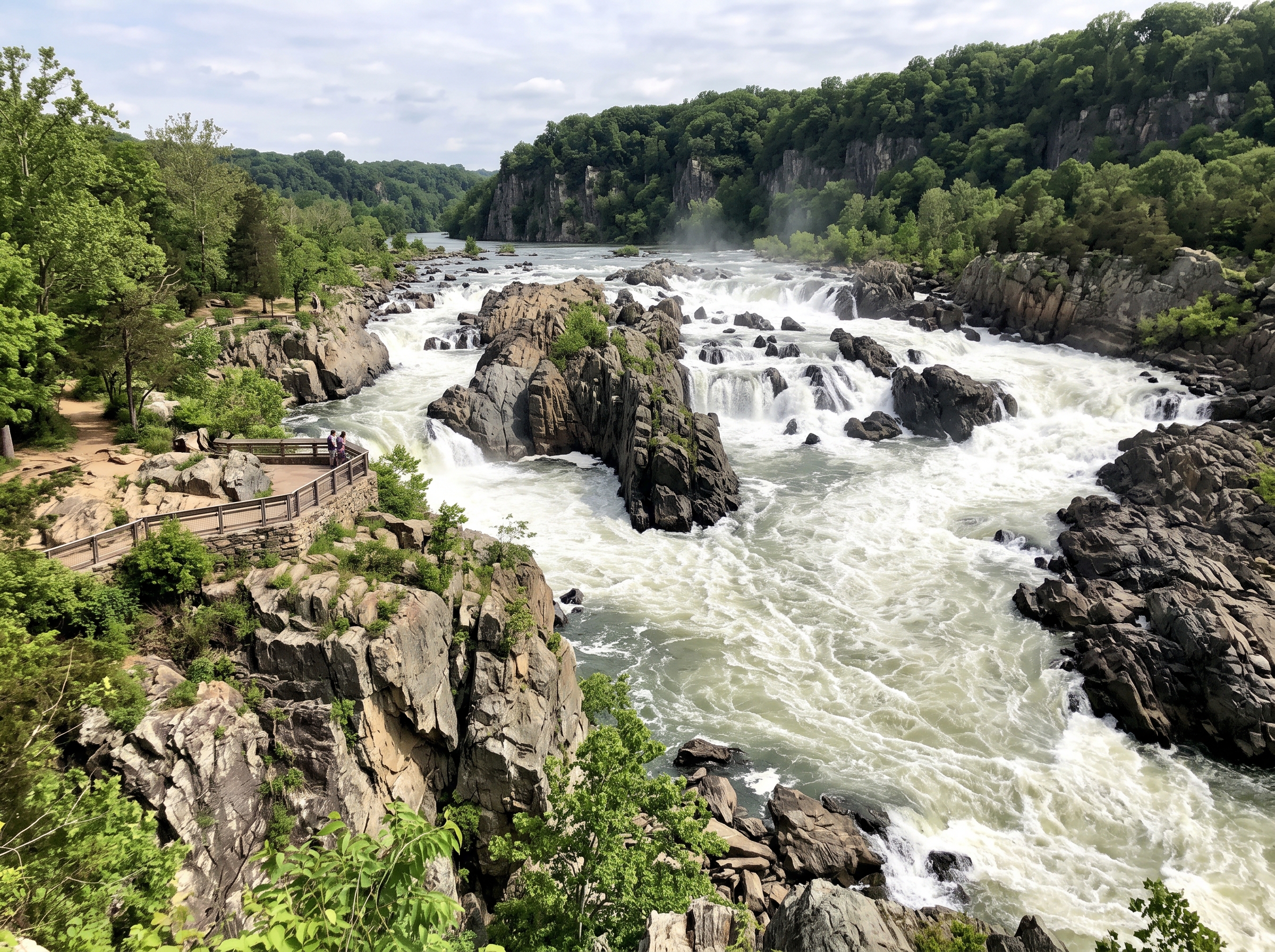
Bordered by the thunderous rapids of Great Falls Park, the peaceful riverfront trails of Riverbend Park, and the scenic historic corridor of Georgetown Pike (Route 193), Great Falls offers an idyllic country lifestyle within a 20-to-30 minute drive of Tysons, the Dulles Technology Corridor, and downtown Washington, D.C. The community's enduring prestige is further anchored by top-tier public education within the nationally acclaimed Langley High School pyramid and a vibrant, colonial-style Village Center.
The Six Structural Pillars of Great Falls Real Estate
- Mandatory 2-Acre Estate Zoning (R-E). Binding statutory minimum lot sizes of two acres across the community, ensuring expansive privacy buffers, long setbacks, and complete protection against tract developments.
- Universal Well & Septic Infrastructure. Complete reliance on private deep-drilled wells and engineered on-site septic drainfields, creating an infrastructural barrier that prevents dense rezoning.
- Potomac Riverfront & Palisades Majesty. Bordered by 800-acre Great Falls Park (Mather Gorge, Patowmack Canal ruins) and 400-acre Riverbend Park, offering unmatched scenic topography and trail networks.
- Langley High School Academic Pyramid. Ranked among the elite public secondary institutions in the United States, driving steady demand from families prioritizing academic rigor and Ivy League matriculation.
- Colonial Village Center & Culinary Landmarks. Anchored by the historic Village Green, weekly farmers markets, community festivals, and celebrated culinary institutions including L'Auberge Chez François and The Old Brogue.
- Equestrian & Country Estate Culture. Extensive private horse farms, riding arenas, and an active network of public and private bridle trails connecting to regional parklands.
2. Comprehensive Historical Evolution
Great Falls' historical progression reflects eighteenth-century civil engineering, nineteenth-century agrarian self-sufficiency, early twentieth-century rail tourism, and a visionary modern commitment to low-density land conservation.
George Washington & The Patowmack Canal (1785)
Long before residential settlement, the area was a focal point of American economic strategy. In 1785, George Washington founded the Patowmack Company to construct a bypass canal around the impassable Great Falls of the Potomac River, aiming to link the Atlantic seaboard with the Ohio River Valley. Completed in 1802, the Patowmack Canal was one of the earliest engineered canal systems in the United States, utilizing innovative stone lock chambers to lower cargo boats through the rocky gorge. The stone ruins of the locks and the historic canal town of Matildaville remain preserved within Great Falls Park.
From Forestville to Great Falls (19th Century to 1905)
Throughout the nineteenth century, the community was known as Forestville, named for the dense stands of virgin oak, hickory, and chestnut that covered the rolling hills. The crossroads featured blacksmith shops, sawmills, a post office, and productive family dairy farms and apple orchards. In 1905, the community was officially renamed Great Falls to avoid confusion with another Forestville located in neighboring Maryland.
The Great Falls & Old Dominion Railroad (1906–1934)
In 1906, John R. McLean and Senator Stephen B. Elkins chartered the Great Falls and Old Dominion Railroad (later integrated into the Washington and Old Dominion system). The electric trolley line transported passengers from Rosslyn and Georgetown directly to the palisades of Great Falls, transforming the scenic wilderness into a fashionable destination for summer day-trippers, artists, and dignitaries seeking refuge from the capital. Passenger rail service ceased in 1934, returning the area to agricultural seclusion before its modern evolution into an estate community.
3. Potomac Riverfront, Palisades & Riverbend Parklands
Great Falls is distinguished by some of the most dramatic geological formations in the eastern United States. Here, the Potomac River narrows sharply, dropping 76 feet over a series of steep cascading rapids into the sheer, jagged cliffs of Mather Gorge:
- Great Falls Park: Managed by the National Park Service across 800 acres, this national park features three dramatic waterfall overlooks, the historic Patowmack Canal trail, rock climbing along the gorge cliffs, and rugged hiking paths connecting directly into the regional trail grid.
- Riverbend Park: Operated by the Fairfax County Park Authority along more than two miles of Potomac River shoreline, this 400-acre sanctuary offers a nature visitor center, boat ramps for canoes and kayaks, riverside picnic pavilions, and brilliant spring carpets of Virginia bluebells.
- Potomac Heritage National Scenic Trail: Connecting directly through Riverbend and Great Falls parks, this federal trail allows residents to hike or run continuously along the river corridor from Loudoun County south to Mount Vernon.
- Difficult Run Stream Valley: A deep forested ravine forming the southern boundary between Great Falls and McLean, offering equestrian paths and connecting to the 40-mile Cross County Trail (CCT).
4. Housing Stock Typologies & Architectural Stratification
Because Great Falls enforces a strict two-acre minimum lot standard, its housing stock is composed entirely of bespoke custom residences and expansive architectural estates:
1. Potomac Blufftop & Riverfront Manors
Sited along the elevated river ridges and private peninsulas overlooking the Potomac River, these landmark estates occupy two to ten or more manicured acres. Architectural styles include monumental stone European manors, French châteaux, and grand brick Georgian revivals. Residences feature 8,000 to 20,000+ square feet of living space, gated motor courts, heated multi-car garages, indoor athletic facilities, wine cellars, separate staff quarters, and resort-style infinity pools framing water views.
2. 2-Acre Custom Interior Wooded Estates
The prevailing residential typology across Great Falls: custom homes constructed between 1985 and the present day on private two- to five-acre parcels. Homes feature hand-laid stone and brick exteriors, grand two-story foyers, commercial-grade chef kitchens, primary bedroom wings with spa bathrooms, and extensive screened porches opening onto mature forest canopies.
3. Modern Farmhouses & Contemporary Masterpieces
An increasingly prominent architectural tier where custom builders create striking transitional and modern farmhouse estates. Characterized by clean horizontal lines, board-and-batten siding, black architectural fenestration, standing-seam metal accent roofs, soaring open-concept floor plans, and state-of-the-art smart-home automation.
4. Equestrian Ranches & Private Horse Farms
Properties spanning 5 to 25+ acres equipped with professional multi-stall barns, wash racks, climate-controlled tack rooms, fenced outdoor riding rings, and grass turnout paddocks, many with direct private access to neighborhood bridle paths.
5. Zoning, Land-Use Governance & The 2-Acre Estate Mandate
Land use across Great Falls is rigorously administered under the Fairfax County Zoning Ordinance (zMOD):
R-E (Residential Estate District)
The dominant zoning classification across Great Falls is R-E, which mandates a minimum lot size of two contiguous acres (87,120 square feet) per single-family dwelling. The code strictly regulates building heights (maximum 35 feet), enforces generous front-, side-, and rear-yard setbacks, and mandates substantial tree canopy retention. These standards prevent visual overcrowding and preserve the rustic pastoral character of the streetscapes.
Universal Private Well & Septic Infrastructure
To prevent suburban tract sprawl, Fairfax County does not extend municipal public sewer service into residential Great Falls. Every single-family estate relies on a private deep-drilled drinking water well and an engineered on-site sewage disposal system (septic drainfield). Meeting Virginia Department of Health percolation and drainfield reserve requirements on private lots acts as a permanent legal and structural barrier against smaller lot subdivisions.
Georgetown Pike Scenic Byway Overlay
Georgetown Pike (Route 193) was the first road in Virginia designated as a Virginia Historic and Scenic Byway. Properties fronting the byway are subject to enhanced setback requirements and scenic easement protections to safeguard historic stone walls, canopy trees, and rural views.
6. Environmental & Watershed Regulation: The Potomac Basin
Because Great Falls drains directly into the Potomac River—a primary source of drinking water for the National Capital Region—environmental protections are rigorous.
Under the Chesapeake Bay Preservation Act, statutory 100-foot Resource Protection Areas (RPAs) border all perennial streams, including Difficult Run, Captain Hickory Run, Nichols Run, and their contiguous wetlands. Within these 100-foot buffer zones, native tree clearing, grading, and impervious construction are strictly curtailed to filter runoff and protect stream bank stability. In addition, the county enforces strict steep-slope protection overlays along the river palisades to prevent soil erosion.
7. Multimodal Transportation & Commuter Arteries
Great Falls balances secluded countryside living with direct access to major Northern Virginia commercial and technology corridors:
- Georgetown Pike (Route 193): The primary historic east-west scenic artery, providing a direct, beautiful commute east into McLean, Route 123 (Chain Bridge), the George Washington Memorial Parkway, and the Capital Beltway (I-495).
- Route 7 (Leesburg Pike): A high-capacity regional arterial forming the southern boundary of Great Falls, recently expanded with continuous shared-use bike and pedestrian paths, connecting directly east to Tysons and west to Loudoun County.
- Walker Road & Springvale Road: Picturesque north-south collector roads linking residential estate neighborhoods to the Village Center, Riverbend Park, and Route 7.
- Silver Line Metrorail Connectivity: Commuters enjoy rapid access to the Washington Metro Silver Line via the Wiehle-Reston East Station and Spring Hill Station in Tysons, each located within a 10-to-15 minute drive.
8. Public Education & The Langley Academic Pyramid
Great Falls is served by the prestigious Fairfax County Public Schools (FCPS) system, universally assigned to the elite Langley High School pyramid:
Langley High School
Consistently ranked among the top public high schools in the Commonwealth of Virginia and the entire nation, Langley High School is celebrated for its extraordinary academic rigor. The school boasts near-universal college matriculation rates, with substantial percentages of graduates advancing to Ivy League institutions and elite research universities. Langley offers extensive Advanced Placement (AP) curricula, competitive STEM research programs, award-winning choral and orchestral ensembles, and perennial state championship varsity athletic teams.
Cooper Middle School & Feeder Elementary Network
Middle school students attend Cooper Middle School, an acclaimed campus featuring a dedicated Advanced Academic Program (AAP) center. Elementary feeder schools include premier neighborhood institutions:
- Great Falls Elementary School: Situated in the heart of the village, offering small class sizes, Japanese language immersion, and exceptional community engagement.
- Forestville Elementary School: Renowned for high academic achievement and active parent-teacher organizations.
- Colvin Run Elementary School: A premier elementary campus hosting an AAP center and specialized STEM science labs.
9. Great Falls Village Center & Cultural Life
The civic and social heart of the community is the colonial-style Great Falls Village Center, situated at the junction of Georgetown Pike and Walker Road. Designed with traditional brick facades, white trim, and a central landscaped Village Green, the center hosts beloved community traditions:
- The Village Green & Gazebo: Home to Saturday morning farmers markets, summer evening "Concerts on the Green," outdoor movie nights, and the annual holiday tree lighting.
- 4th of July Celebration: A cherished historic tradition featuring a community parade of antique cars and horses, 5K road race, family carnival on the green, and an evening fireworks display.
- L'Auberge Chez François: Founded in 1976 on six wooded acres by Chef François Haeringer, this world-renowned French country dining destination is celebrated nationally for authentic Alsatian cuisine, garden patios, and world-class wine pairings.
- The Old Brogue Irish Pub: A historic community gathering spot in the Village Center offering casual dining, live Celtic music, and outdoor patio seating.
10. Equestrian Culture & Bridle Trail Networks
Horse ownership is an integral thread of Great Falls' cultural identity. Under Fairfax County R-E zoning, keeping horses is permitted by right on qualifying two-acre parcels (typically requiring two acres for the first horse and additional land per additional horse). Numerous private farms feature professional indoor/outdoor arenas, dressage facilities, and custom barns. A coordinated network of public and private bridle easements spans the community, allowing riders to travel across rolling countryside directly into the trail networks of Riverbend Park and Great Falls Park.
11. Parks, Trails & Outdoor Recreation
Recreational opportunities in Great Falls are shaped by the great outdoors:
- Hiking along Mather Gorge: The River Trail and Billy Goat Trail offer world-class hiking along granite cliffs overlooking Class V whitewater rapids.
- Whitewater Kayaking & Boating: Great Falls is an internationally famous destination for whitewater kayakers tackling the Potomac River gorge, while Riverbend Park provides calm water for recreational paddling.
- Turner Farm Park: A 52-acre park featuring professional equestrian facilities, cross-country jumping courses, multi-purpose athletic fields, and the Turner Farm Observatory, offering public astronomy viewing through powerful telescopes.
12. Comprehensive Submarket Matrix Table
The table below contrasts the distinct residential micro-markets across Great Falls, highlighting architectural typologies, lot dimensions, utilities, and governance structures:
| Submarket / Sector | Primary Architectural Typology | Dominant Construction Era | Density & Lot Size Profile | Water & Wastewater Infrastructure | Governance & HOA Structure |
|---|---|---|---|---|---|
| Potomac Bluff & Riverfront Manors | Stone French Châteaux, European Manors, Custom Contemporary | 1990s – Contemporary Custom | Low Density; 2.0 to 10.0+ Acres | Private Deep Well & Engineered Septic | Fee-Simple Ownership; Non-HOA / Private Gated Covenants |
| 2-Acre Interior Wooded Estates | Custom Brick Colonials, Stone Manors, Craftsman | 1985 – Present | R-E Zoning; 2.0 to 5.0 Acres | Private Deep Well & Engineered Septic | Fee-Simple Ownership; Predominantly Non-HOA |
| Equestrian & Country Holdings | Country Farmhouses, Custom Ranches with Stables | 1975 – Present | Low Density; 5.0 to 25.0+ Acres | Private Deep Well & Engineered Septic | Fee-Simple Ownership; Equestrian Right-to-Farm |
| Village Center Periphery | Transitional Colonials, Modern Farmhouses, Infill | 1980s – Contemporary Custom | R-E Zoning; 2.0 to 3.5 Acres | Private Deep Well & Engineered Septic | Fee-Simple Ownership; Walkable to Village Green |
13. Taxation & Civic Governance
As an unincorporated community governed directly by Fairfax County within the Dranesville Magisterial District, Great Falls operates under a streamlined tax and administrative structure:
Ad Valorem Real Estate Assessments
All real property in Great Falls is assessed annually at 100% fair market value by the Fairfax County Department of Tax Administration (DTA) in strict accordance with Virginia Code Title 58.1. Taxes are billed semi-annually. Because Great Falls is not an incorporated municipality, property owners pay solely the unified Fairfax County real estate tax and standard countywide service levies, avoiding secondary town taxes.
Fee-Simple Ownership Autonomy vs. Private Enclaves
The overwhelming majority of homes in Great Falls operate as fee-simple properties with no mandatory homeowner association (HOA) dues, granting owners maximum autonomy over exterior design, outbuilding construction, and landscaping within county zoning parameters. Certain private enclave cul-de-sacs maintain modest road maintenance agreements or architectural covenants governed by the Virginia Property Owners' Association Act (POAA).
14. 10 Comprehensive Evergreen FAQs
1. Is Great Falls an incorporated town or an unincorporated community?
Great Falls is an unincorporated census-designated place (CDP) situated in the Dranesville Magisterial District of northern Fairfax County. It possesses no independent town charter or town council. Municipal administration, law enforcement, public education, and property taxation are managed directly by Fairfax County, meaning homeowners pay strictly the unified county real estate tax without separate town levies.
2. What is the 2-acre minimum zoning requirement in Great Falls?
Under the Fairfax County Zoning Ordinance (zMOD), the predominant residential classification across Great Falls is R-E (Residential Estate), which mandates a minimum parcel size of two contiguous acres (87,120 square feet) per single-family residence. This statutory density restriction preserves expansive wooded buffers, safeguards privacy, and prevents high-density suburban tract subdivision.
3. Do properties in Great Falls use public water and sewer or private systems?
The vast majority of residential homes in Great Falls rely on private deep-drilled drinking water wells and engineered on-site sewage disposal systems (septic drainfields). The deliberate absence of municipal public sewer mains across the R-E zoning district serves as an immutable physical and legal safeguard reinforcing the community's low-density estate character.
4. What architectural home styles define Great Falls real estate?
Great Falls features exceptional architectural diversity across its multi-acre parcels: monumental custom stone and brick European manors, French Provincial and Georgian estates, bespoke contemporary residences with floor-to-ceiling glass walls, sprawling equestrian farmhouses with private barns, and modern transitional craftsman estates.
5. Which public schools serve Great Falls residents?
Great Falls is served by Fairfax County Public Schools (FCPS) within the nationally acclaimed Langley High School pyramid. Langley High School is consistently ranked among the top public high schools in Virginia and the United States. Feeder schools include Cooper Middle School (AAP center) and prestigious neighborhood elementary campuses including Great Falls Elementary, Forestville Elementary, and Colvin Run Elementary.
6. What is the historic significance of Great Falls Park and the Patowmack Canal?
Great Falls Park is an 800-acre National Park Service site where the Potomac River drops 76 feet through Mather Gorge. The park preserves the historic stone ruins of the Patowmack Canal, chartered in 1785 and overseen by George Washington as one of the first engineered bypass canals in American history designed to open trade routes to the Ohio River Valley.
7. What is the Great Falls Village Center and what amenities does it offer?
The Great Falls Village Center, situated at the intersection of Georgetown Pike (Route 193) and Walker Road, serves as the community's colonial-style commercial and civic hub. It features a historic village green with a gazebo, weekly farmers markets, art galleries, boutique shops, and celebrated restaurants including The Old Brogue Irish Pub, alongside neighboring institutions like the world-famous L'Auberge Chez François.
8. Are equestrian properties and horse keeping permitted in Great Falls?
Yes, Great Falls is one of the premier equestrian centers in the Washington metropolitan area. Under Fairfax County R-E zoning, horse keeping is permitted by right on qualifying multi-acre parcels. The community maintains an active network of private and public bridle trails connecting private stables to regional parklands.
9. What major transportation corridors connect Great Falls to regional employment centers?
The primary east-west corridors are Georgetown Pike (Route 193, a designated Virginia Scenic Byway connecting east to McLean, Route 123, and the Beltway) and Route 7 (Leesburg Pike, connecting east to Tysons and west to Loudoun County). Commuters also enjoy rapid access to the Silver Line Metrorail stations in nearby Reston and Tysons.
10. Do homes in Great Falls have mandatory homeowner associations (HOAs)?
Many multi-acre properties in Great Falls operate as independent fee-simple holdings with no mandatory HOA dues, giving owners maximum architectural freedom within county zoning parameters. Certain private cul-de-sacs and enclave developments have small, private road maintenance or architectural covenants governed under the Virginia Property Owners' Association Act (POAA).
15. Legal & Fair Housing Disclaimer
This real estate and community monograph is published strictly for informational, educational, and demographic research purposes. All municipal boundaries, zoning districts, school attendance zones, tax assessments, and parkland boundaries are derived from official Fairfax County public records, the National Park Service (NPS), the Virginia Department of Transportation (VDOT), and the Code of Virginia, and are subject to periodic administrative modification. Prospective purchasers, sellers, and investors must independently examine official property disclosures, deed encumbrances, health department well and septic certifications, and scenic byway easements through licensed legal and real estate professionals prior to executing contractual agreements. This publication strictly adheres to Title VIII of the Civil Rights Act of 1968 (The Federal Fair Housing Act) and the Virginia Fair Housing Law, prohibiting discrimination on the basis of race, color, religion, sex, handicap, familial status, elderliness, or national origin.