
Herndon, VA Real Estate: The Definitive Guide to Historic Preservation, Zoning & the Dulles Tech Corridor
1. Executive Summary & Foundational Takeaways
Herndon, Virginia, occupies an exceptional position within the political geography, spatial economics, and residential morphology of Fairfax County. Situated twenty-two miles west-northwest of Washington, D.C., and immediately east of Washington Dulles International Airport, Herndon functions not merely as an affluent suburban node within the National Capital Region, but as a dual-jurisdictional landscape defined by an acute legal and spatial dichotomy.
The first jurisdictional entity is the Incorporated Town of Herndon (ZIP Code 20170). Chartered by the Virginia General Assembly in 1879, this municipal corporation spans 4.2 square miles and maintains full municipal self-determination. The Town exercises statutory sovereignty through an elected Mayor and six-member Town Council, an independent municipal police department (the Herndon Police Department), an autonomous Department of Public Works managing capital roads, public water distribution, and seasonal municipal utilities, an independent planning and zoning apparatus codified in Chapter 78 of the Herndon Town Code, and an Architectural Review Board (ARB) wielding regulatory control over the Heritage Preservation Overlay District.
The second entity is Greater Herndon / Oak Hill (ZIP Code 20171). Located south of the Dulles Toll Road and extending toward the Loudoun County boundary and Route 50, this sector is unincorporated land governed directly by the Fairfax County Board of Supervisors (split between the Hunter Mill and Sully Magisterial Districts). Here, land use is governed by the Fairfax County Zoning Ordinance (zMOD), law enforcement is dispatched through the Fairfax County Police Department's Reston and Fair Oaks District Stations, and physical planning is steered by the Fairfax County Comprehensive Plan.
The Six Structural Pillars of Herndon Real Estate
- Municipal Autonomy vs. County Scale. The coexistence of small-town administrative intimacy and specialized municipal civil services alongside the deep institutional and economic resources of Fairfax County.
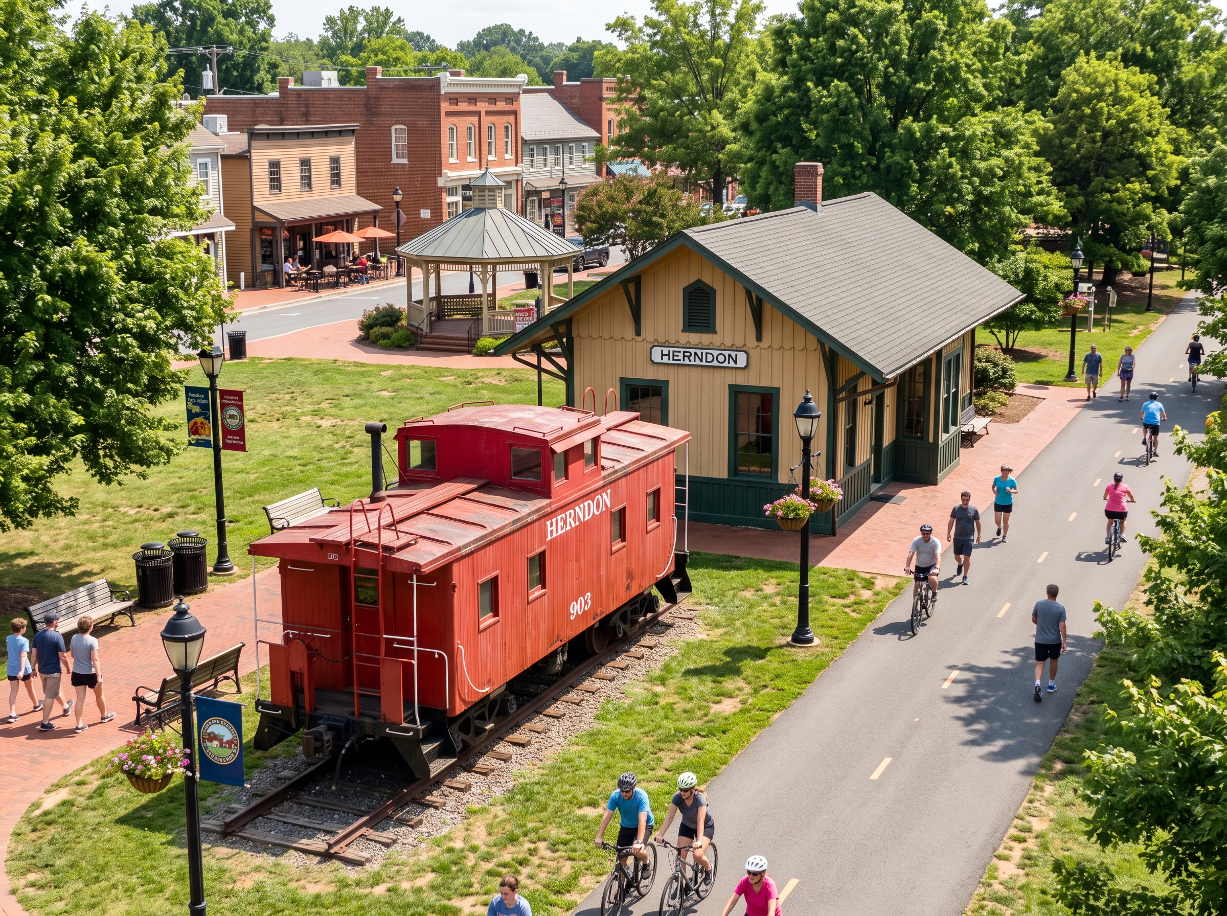
- The Washington & Old Dominion (W&OD) Urban Greenway. A 45-mile paved linear park slicing directly through the historic town center, serving as a recreational spine and an active non-motorized commuter corridor.
- Heavy-Rail Metrorail Infrastructure. The delivery of the Herndon Metrorail Station on the Washington Metro Silver Line, connecting Herndon to the Dulles Technology Corridor, Reston, Tysons, and downtown Washington, D.C.
- Sugarland Run Watershed Protections. Stringent environmental zoning dictated by the Sugarland Run and Folly Lick Branch watersheds under the Chesapeake Bay Preservation Act, enforcing mandatory 100-foot Resource Protection Area (RPA) vegetative buffers.
- The Herndon High School Academic Pyramid. A high-caliber educational feeder matrix within Fairfax County Public Schools (FCPS), featuring specialized Naval Junior Reserve Officers Training Corps (NJROTC) instruction, Advanced Academic Programs (AAP), and celebrated performing arts academies.
- Historic District Preservation. An authentic 19th-century railroad-era core protected by rigorous architectural design review, surrounded by mature late-20th-century planned communities and high-density transit-oriented mixed-use developments.
Quick Navigation: Herndon Monograph Sections
2. Comprehensive Historical Evolution
Before European settlement, the rolling Piedmont terrain of northwestern Fairfax County was traversed by the Doeg and Algonquin-speaking peoples, as well as the migratory hunting routes of the Haudenosaunee (Iroquois) along the Potomac fall lines. During the early 18th century, the territory fell within the Northern Neck Proprietary—a vast 5.2-million-acre royal grant inherited by Thomas Fairfax, 6th Lord Fairfax of Cameron.
Large agrarian patents were subdivided along the tributaries of Sugarland Run and Horsepen Run. Settlers established subsistence farms and tobacco plantations, although the fragile clay soils of the Piedmont were rapidly depleted by repetitive tobacco cultivation. By the late 18th and early 19th centuries, agricultural production shifted toward winter wheat, rye, and orchard fruits. Grist mills and sawmills were erected along Sugarland Run, establishing small settlement clusters centered on water-powered industry. The rural crossroads was originally known colloquially as Runnymede or Chestnut Grove.
The Naming of Herndon & Naval Heroism (1857–1858)
The transformation of the rural crossroads into an organized town began with the construction of the Alexandria, Loudoun & Hampshire (AL&H) Railroad in the 1850s. Engineered to connect the deepwater port of Alexandria with the agricultural interior of the Shenandoah Valley, the rail line established a scheduled depot stop at the crossroads in 1857.
In September 1857, Commander William Lewis Herndon (1813–1857)—a celebrated U.S. Navy officer and author of the first federal exploration of the Amazon Valley—captained the commercial mail steamer SS Central America when it encountered a Category 2 hurricane off Cape Hatteras. Over a thirty-hour battle against rising bilge waters, Herndon supervised the evacuation of 152 women and children onto a passing vessel. Remaining on the hurricane deck in full dress uniform, he went down with his vessel. In 1858, when the community gathered to formalize the designation of their new post office, the assembled citizens voted unanimously to honor Commander Herndon, establishing an enduring civic tradition of maritime valor.
Civil War Espionage & Guerrilla Skirmishes (1861–1865)
The Civil War fractured western Fairfax County. Because northern-born immigrant farmers had settled in the area during the 1850s, Herndon harbored divided loyalties. The AL&H Railroad depot made the village a target for raids, supply interdiction, and intelligence operations.
Herndon became a primary theater of operations for Colonel John Singleton Mosby and the 43rd Battalion, Virginia Cavalry (Mosby’s Rangers). On March 17, 1863, during the Herndon Station Raid, Mosby surprised an encampment of the 1st Vermont Cavalry at the Herndon Depot, capturing twenty-one Union pickets, their mounts, and equipment without suffering a single casualty. Concurrently, southern spy Laura Ratcliffe operated out of the nearby Merrybrook estate along Centreville Road, relaying critical Union troop movements to Mosby and Major General J.E.B. Stuart using concealed drop locations such as Spy Rock.
1879 Town Incorporation & The Dairy Farming Capital (1870–1930)
In the reconstruction era, inexpensive farmland attracted northern Quaker and dairy farming families from New York and Pennsylvania. These settlers introduced lime-based soil remediation, crop rotation, and mechanized dairy husbandry. Reconstituted as the Washington & Old Dominion (W&OD) Railroad, the line provided express freight transit into Washington, D.C., transforming Herndon into the dairy transportation capital of Northern Virginia.
To manage this growing commercial hub, provide road maintenance, and maintain public order, the Virginia General Assembly granted the Town of Herndon its formal Municipal Charter on January 14, 1879. Prosperous merchant families constructed late-Victorian, Queen Anne, Italianate, and Folk Victorian residences along Elden, Station, Pine, and Lynn Streets, establishing the historic streetscapes that anchor the municipality today.
Modern Suburban Era & The Dulles Technology Corridor (1960–Present)
The opening of Washington Dulles International Airport in 1962 and the completion of the Dulles Toll Road (Route 267) in the 1980s transformed Herndon’s southern perimeter into the core of the Dulles Technology Corridor. International telecommunications firms, defense contractors, software providers, and systems integrators built campus hubs across Worldgate, Dulles Corner, and Woodland Park.
This transformation culminated with the opening of the Herndon Silver Line Metrorail Station in the median of the Dulles Toll Road, establishing direct heavy-rail transit connectivity between Herndon, Reston, Tysons, and Washington, D.C., and sparking transit-oriented infill development while reinforcing preservation protections across the historic municipal center.
3. Physical Geography, Topography & Hydrology
Herndon lies entirely within the Piedmont Physiographic Province, positioned in the rolling upland sub-region known as the Culpeper Basin. The terrain features undulating hills, rounded ridges, and dendritic stream valleys:
- Elevations & Subsurface Geology: Elevations range from 360 feet above sea level along the northern Sugarland Run stream valley to 420 feet across the south-central residential ridges near Herndon Parkway and Fox Mill Road. The bedrock consists of Triassic sedimentary rock formations—specifically the Catharpin Creek and Bull Run formations, composed of interbedded siltstone, shale, and red sandstone.
- Soil Associations: Soils belong primarily to the Penn-Bucks and Dulles-Orange associations, consisting of moderately deep silty clay loams with moderate shrink-swell potential, requiring careful engineering of foundation footings and perimeter drainage systems.
Watershed Systems & Chesapeake Bay Preservation Act (CBPA) Protections
Herndon is drained by two primary hydrological corridors flowing northward toward the Potomac River:
- Sugarland Run Watershed: The primary hydrological spine of western Herndon, flowing through Runnymede Park into Loudoun County. Its broad alluvial floodplains provide regional stormwater retention and aquifer filtration.
- Folly Lick Branch: A major eastern tributary carving an incised ravine through eastern residential sectors, including Kingston Chase and the Dranesville Road corridor.
Under the Chesapeake Bay Preservation Act (Virginia Code § 62.1-44.15:67 et seq.), both the Town of Herndon and Fairfax County enforce mandatory 100-foot Resource Protection Area (RPA) vegetative buffer zones landward of all perennial streams. Within this 100-foot buffer, clearing, grading, paving, and constructing permanent structures (including pools, home additions, and detached garages) are prohibited by statute. For parcels bordering Sugarland Run or Folly Lick Branch, RPA encumbrances significantly influence the buildable lot envelope, protecting natural corridors while shaping property yield.
4. The Complete Herndon Neighborhood Dossier
Historic Downtown Herndon & Heritage Preservation District (20170)
Centered on Elden, Station, Lynn, and Church Streets, the historic downtown forms the pedestrian core of ZIP code 20170. The housing stock features Queen Anne Victorian merchant homes with wraparound porches, Folk Victorian cottages, American Foursquares, and authenticated Sears kit homes (including the Vallonia and Osborn models), alongside 21st-century luxury townhomes. Residents enjoy immediate walking access to the Town Green, the Fortnightly Library, local bakeries, cafes, and the W&OD Trail. All exterior modifications within the HPOD boundary require approval from the Town Architectural Review Board.
Runnymede Park & The Sugarland Valley Enclave (20170)
Tucked along the northwestern town boundary flanking Herndon Parkway and Old Hunt Way, this wooded neighborhood directly abuts the 58-acre Runnymede Park nature sanctuary. Properties consist of detached custom single-family homes built between the late 1970s and 2000s on parcels ranging from 12,000 to 25,000 square feet. Homes backing directly onto the park enjoy permanent natural privacy buffers and direct trail connections.
Kingston Chase & The Dranesville Corridor (20170)
An established single-family residential community comprising 539 platted home sites located in the northeastern quadrant of ZIP code 20170, bordered by Dranesville Road and the Folly Lick Branch stream valley. Developed predominantly during the 1970s, Kingston Chase features center-hall colonials, traditional split-levels, and split-foyer residences on 8,500 to 12,000 square foot lots with mature tree canopies. The neighborhood association maintains a private pool facility with a competition swim team, tennis/pickleball courts, and direct trail access into Folly Lick Branch.
Bradley Farm & Stuart Ridge (20170)
Situated adjacent to the southern quadrant of Herndon Parkway with immediate access to Elden Street and Route 267, these subdivisions were constructed during the mid-1980s to early 1990s. The communities consist of traditional detached colonials with brick-front facades, two-car garages, and finished basements, alongside fee-simple townhome clusters. Community associations maintain private pools, tot lots, and walking paths.
Herndon Metro Station & The Transit-Oriented Urban Core (20170 / 20171)
Spanning the high-density residential and commercial zone around the Herndon Metrorail Station, extending north toward Worldgate Centre and south toward Arrowbrook Centre and Woodland Park. The housing stock features luxury condominium mid-rises (such as The Bryson at Woodland Park, comprising 585 units) with underground garage parking, fitness centers, and swimming pools, alongside contemporary multi-level townhomes with rooftop terraces and ground-floor retail amenities.
Greater Herndon / Oak Hill Executive Borders (20171)
Located in unincorporated Fairfax County south of the Dulles Toll Road, this sector features expansive master-planned communities and executive subdivisions:
- Franklin Farm: A premier 1,681-home master-planned development encompassing over 820 acres, with six community fishing ponds, thirteen miles of paved multi-use trails, two competitive swimming facilities, tennis courts, and neighborhood shopping centers.
- Fox Mill Estates: A mature single-family enclave comprising 1,372 homesites characterized by third-acre to half-acre parcels, lush tree canopies, and classic two-story colonials.
- Chantilly Highlands: A 963-home subdivision featuring center-hall colonials, community pool and athletic facilities, feeding directly into top-tier public school pyramids.
- Estate Properties: Custom executive residences on half-acre to two-acre lots along West Ox Road and the rural boundary, governed under Fairfax County R-C and R-1 residential zoning.
5. Architectural Typologies
Herndon's residential architecture spans more than a century of evolving design forms:
- Late 19th-Century Victorian, Folk Victorian & Queen Anne (1870–1910): Concentrated in the historic core, featuring balloon timber framing, coursed stone or brick pier foundations, steeply pitched cross-gables, standing-seam metal roofs, decorative bargeboards, wraparound verandas, turned spindlework, and original wavy-glass windows.
- Early 20th-Century Craftsman Bungalows & Sears Kit Homes (1910–1940): Low-slung horizontal massing, broad overhanging eaves with exposed rafter tails, tapered columns on rusticated stone or brick piers, central American Foursquare plans, and interior built-in cabinetry.
- Mid-Century Brick Ramblers & Split-Levels (1950–1975): Single-level ranches with low-pitched roofs, brick masonry veneers, broad picture windows, and multi-level split-levels designed to step naturally with the rolling Piedmont terrain.
- 1980s–1990s Transitional Executive Colonials (1980–2000): Poured-concrete basements, two-story center-hall layouts, brick-front facades, two-car garages, vaulted entrance foyers, Palladian windows, and open kitchen-to-family-room floorplans.
- 21st-Century Infill Modern Farmhouses & Transit Flats (2015–Present): High-efficiency construction, fiber-cement and board-and-batten exteriors, black architectural windows, metal porch accents, private rooftop terraces, and transit-oriented loft flats.
6. Municipal Zoning & Infill Land-Use Framework
A key element of Herndon's real estate landscape is the regulatory distinction between the Town of Herndon Zoning Ordinance (Chapter 78) and the Fairfax County Zoning Ordinance (zMOD):
- R-10 Single-Family Residential (Town): Minimum lot area of 10,000 square feet; minimum lot width of 80 feet; setbacks: front 30 feet, side 10 feet (minimum combined 25 feet), rear 30 feet; maximum building height 35 feet.
- R-15 Single-Family Residential (Town): Minimum lot area of 15,000 square feet; minimum lot width of 100 feet; setbacks: front 35 feet, side 15 feet each, rear 35 feet.
- Planned Development - Traditional Downtown (PD-TD): Mixed-use zoning emphasizing pedestrian-oriented street walls, shallow setbacks, ground-floor retail or civic activation, integrated structured parking, and upper-floor residential lofts.
- Heritage Preservation Overlay District (HPOD) & ARB: Administered by the Town Architectural Review Board. Mandatory Certificates of Appropriateness (COA) are required for all visible exterior modifications to preserve historic architectural integrity.
- Fairfax County Zoning (zMOD) in 20171: Unincorporated areas operate under county zoning classifications—including R-1 (40,000 sq ft lots), R-2 (20,000 sq ft lots), R-3 (12,000 sq ft lots), and Planned Development Housing (PDH) districts that govern master-planned subdivisions.
7. Educational Ecosystem & School Pyramids
Herndon is served by Fairfax County Public Schools (FCPS), recognized among the nation's leading public school systems. The primary educational pyramid is centered on Herndon High School:
- Herndon High School: Established in 1904, the campus has undergone comprehensive modernization. It features a distinguished Naval Junior Reserve Officers Training Corps (NJROTC) unit, extensive Advanced Placement (AP) courses, dual-enrollment pathways, and an internationally celebrated fine arts department, including "The Pride of Herndon" marching band.
- Herndon Middle School: Feeder middle school providing rigorous academic foundations, honors tracks, and Level IV Advanced Academic Programs (AAP) local delivery.
- Elementary Feeders: Includes Herndon Elementary (offering a celebrated French Dual-Language Immersion Program), Clearview Elementary, Dranesville Elementary, and Hutchison Elementary.
- Advanced Academics & STEM Pathways: Students qualify for full-time Level IV Advanced Academic Programs (AAP) centers and are eligible to apply to the prestigious Thomas Jefferson High School for Science and Technology (TJHSST) in Alexandria.
8. Multi-Modal Commuting & Regional Arterials
Herndon offers diverse multi-modal transportation options connecting residents across Northern Virginia and the greater metropolitan region:
- Herndon Metrorail Station (Silver Line): Located in the median of Route 267 adjacent to the Herndon-Monroe commuter lot. Features a structured garage with 3,500 spaces, covered pedestrian bridges, and direct transit: approximately 10 minutes to Dulles Airport, 3 minutes to Reston Town Center, 18 minutes to Tysons, and 42 to 45 minutes to downtown Washington, D.C.
- Highway Grid: Route 267 (Dulles Toll Road) provides express links east to I-495 and I-66; Fairfax County Parkway (Route 286) connects north to Route 7 and south to I-66; Route 28 provides grade-separated access to Dulles Airport and Loudoun County; Elden Street / Route 228 serves as the north-south commercial spine; and the four-lane Herndon Parkway loop routes through-traffic smoothly around the historic town center.
- The W&OD Railroad Regional Park: A 45-mile paved linear greenway running directly through downtown Herndon. Maintained and cleared year-round by Town Public Works crews, it functions as a recreational path and an active bicycle commuting route eastward toward Reston, Vienna, Tysons, and Arlington.
9. Parks, Community Life & Civic Institutions
Herndon balances economic vitality with rich recreational and cultural amenities:
- Runnymede Park: A 58-acre passive nature sanctuary along Herndon Parkway featuring native meadows, non-tidal wetlands, elevated boardwalks, and bird watching stations along Sugarland Run.
- Herndon Centennial Golf Course: An 18-hole municipal par-71 golf course owned and operated by the Town of Herndon, featuring tree-lined fairways, practice putting greens, and junior development programs.
- Bready Park & Herndon Community Center: A 56,000-square-foot civic hub with a 25-yard heated indoor competition pool, fitness center, racquetball courts, gymnasium, lighted baseball diamonds, and artificial turf athletic fields.
- Civic Traditions: Friday Night Live outdoor concerts on the Town Green, the weekly Herndon Farmers Market along Lynn Street, the historic 1857 Herndon Depot Museum, and the annual Herndon Festival.
10. Fiscal Architecture, Taxation & HOA Nuances
Under Virginia Code Title 58.1-3201, all real property is assessed annually at 100 percent of fair market value by the Fairfax County Department of Tax Administration using computer-assisted mass appraisals:
- Unincorporated Herndon / Oak Hill (20171): Homeowners pay the Fairfax County Base Real Estate Levy, the countywide Stormwater Service District assessment, and regional transportation funds. Municipal services are provided via Fairfax County police, VDOT road maintenance, and private trash contracts.
- Incorporated Town of Herndon (20170): Homeowners are subject to a dual-tax structure, paying both the Fairfax County base levy and the Town of Herndon Municipal Real Estate Levy. In exchange, town residents receive dedicated services: independent police protection through the Herndon Police Department, weekly municipal trash/recycling pickup, seasonal curbside leaf vacuuming, and town street snow clearance.
- HOA Governance: Historic downtown homes are predominantly fee-simple with no mandatory HOA dues, though properties within the HPOD remain subject to Town ARB oversight. Subdivisions platted after 1970 (e.g., Kingston Chase in 20170, and Franklin Farm, Fox Mill Estates, Chantilly Highlands in 20171) maintain mandatory HOAs that manage private pools, courts, common areas, and architectural covenants.
- Mortgage Underwriting Dynamics: Transactions span the threshold between Federal Housing Finance Agency (FHFA) conforming loan limits (with Fairfax County qualifying for high-cost baseline caps) and jumbo non-conforming portfolio underwriting, which requires larger asset reserves and strict debt-to-income reviews for executive homes.
11. Strategic Buyer Guidance
- Historic ARB Review: Verify whether a parcel falls inside the Heritage Preservation Overlay District. If so, plan for ARB Certificate of Appropriateness reviews before scheduling exterior renovations, window replacements, or additions.
- Hydrological Due Diligence: Review Fairfax County GIS maps to verify 100-foot Resource Protection Area (RPA) buffers along Sugarland Run and Folly Lick Branch. Check FEMA flood maps and verify that full basements feature perimeter French drains and dual sump pumps with battery backups.
- Commuter Alignment: Weigh proximity to the Herndon Silver Line Metrorail station against highway access to Route 267 and Route 28 based on daily transit needs.
12. Strategic Seller Guidance
- Highlighting Location & Transit: Emphasize pedestrian connectivity to the W&OD Trail, downtown shops, or the Herndon Metrorail Station to attract transit-oriented buyers.
- Architectural Staging: For historic homes, highlight original craftsmanship (heart pine flooring, moldings, wraparound porches) while showcasing updated mechanicals and providing documentation of completed ARB approvals. For modern colonials, emphasize open floor plans, home offices, and private backyard outdoor spaces.
13. Submarket Comparative Matrix
| Submarket | Municipal Governance | Typical Lot Dimensions | Governing Land-Use Code | Rail Transit Infrastructure | Dominant Architectural Typologies |
|---|---|---|---|---|---|
| Town of Herndon (20170) | Incorporated Town (Independent Mayor, Council, Police, DPW) | 8,000 to 15,000 sq ft (Typical town parcels) | Town of Herndon Zoning Ordinance (Chapter 78) & ARB Overlay | Herndon Metrorail Station (Silver Line heavy rail) | Late 19th-Century Victorians, Craftsman Bungalows, Infill Modern Farmhouses |
| Reston (Fairfax County) | Unincorporated Master-Planned PUD (Reston Association) | Variable (High-density clusters to 1/3 acre detached) | Fairfax County zMOD & Reston Association Design Review Board (DRB) | Reston Town Center & Wiehle-Reston East Stations (Silver Line) | Mid-Century Modern, Contemporary Vertical Clusters, Urban Mixed-Use High-Rises |
| Sterling (Loudoun County) | Unincorporated Loudoun County | 10,000 to 20,000 sq ft (Suburban platted) | Loudoun County Revised 1993/2023 Zoning Ordinance | Sterling (Innovation Center / Dulles Metro station fringes) | 1960s–1970s Split-Levels, Ranches, Production Colonials |
| Town of Vienna (Fairfax County) | Incorporated Town (Independent Council, Police, DPW) | 10,000 to 15,000 sq ft (RS-10, RS-12.5, RS-16) | Town of Vienna Unified Development Code & Town Council | Vienna/Fairfax-GMU Metrorail Station (Orange Line; outside town borders) | Mid-Century Ramblers, Extensive 21st-Century Luxury Custom Infill Colonials |
| Oakton (Fairfax County) | Unincorporated Fairfax County | 1/2 Acre to 2+ Acres (Low-density suburban/estate) | Fairfax County zMOD (Primarily R-1, R-2, R-C conservation) | Proximate to Vienna Metrorail Station (Orange Line) | Custom Executive Brick Colonials, Contemporary Mansions, Estate Properties |
14. 10 Comprehensive Evergreen FAQs
1. Is Herndon an incorporated town or part of Fairfax County?
Herndon functions as both, operating through an interconnected dual-jurisdictional structure. The Town of Herndon is a legally chartered, self-governing incorporated municipality spanning 4.2 square miles within Fairfax County. It maintains an elected Mayor, Town Council, independent municipal police department, public works department, and autonomous zoning ordinance. However, all town properties are also part of Fairfax County; town residents pay county real estate taxes, vote in county elections, and utilize Fairfax County Public Schools. Conversely, Greater Herndon / Oak Hill (ZIP 20171) lies south of the Dulles Toll Road and is unincorporated land governed directly by the Fairfax County Board of Supervisors, with no municipal town affiliation.
2. Where does the name "Herndon" originate?
The community was named in 1858 in honor of Commander William Lewis Herndon (1813–1857), a distinguished United States Navy officer, oceanographer, and explorer who led the first scientific survey of the Amazon Basin. In September 1857, Commander Herndon captained the commercial mail steamship SS Central America (the "Ship of Gold") when it encountered a Category 2 hurricane off Cape Hatteras. Over a thirty-hour battle against rising bilge waters, Herndon coordinated the rescue of all 152 women and children aboard onto a passing vessel. Remaining on the hurricane deck in full dress uniform, he went down with his vessel. Impressed by his bravery, the crossroads citizens petitioned the Post Office Department to name their rail depot "Herndon."
3. Does Herndon have a dedicated Metrorail station?
Yes. Herndon is served directly by the Herndon Metrorail Station on the Washington Metro Silver Line, located in the median of the Dulles Toll Road (Route 267) adjacent to the Herndon-Monroe Park and Ride facility. Opened in November 2022 as part of the Silver Line Phase 2 extension, the heavy-rail station features pedestrian bridges crossing the highway, a multi-level structured commuter parking garage, and frequent direct service. Commute times run roughly ten minutes west to Washington Dulles International Airport, eighteen minutes east to Tysons, and forty-two to forty-five minutes to the Washington, D.C., regional employment core.
4. How does Town of Herndon zoning differ from Fairfax County?
The Town of Herndon exercises independent statutory zoning authority under Chapter 78 of the Herndon Town Code, completely distinct from the Fairfax County Zoning Ordinance (zMOD). Key differences include:
- Planning and zoning decisions are administered by the Herndon Planning Commission, Town Council, and Town Department of Community Development, rather than county boards.
- Town residential zones establish unique setbacks, maximum building heights, and impervious surface lot coverage limits designed for an intimate town grid.
- Town-administered overlay zoning—including the Heritage Preservation Overlay District and Planned Development Traditional Downtown (PD-TD)—regulates historic preservation, zero-lot-line commercial activation, and town-scale infill projects.
5. How are real estate taxes calculated for Town of Herndon homeowners?
Real estate taxes follow the legal requirements of Virginia Code Title 58.1, which mandates annual assessment of all real property at 100 percent of fair market value by the Fairfax County Department of Tax Administration:
- Homeowners located within the incorporated town pay two separate levies: the Fairfax County Base Real Estate Levy and the Town of Herndon Municipal Real Estate Levy, alongside dedicated stormwater district assessments.
- In exchange for the town levy, residents receive dedicated services: independent police protection through the Herndon Police Department, weekly municipal trash/recycling pickup, seasonal curbside leaf vacuuming, and direct street snow removal by the Town Department of Public Works.
- Homeowners in unincorporated Greater Herndon (ZIP 20171) pay only the Fairfax County levy, relying on county police, VDOT road clearance, and private trash haulers.
6. What public high school pyramid serves Herndon?
The primary public secondary school serving the area is Herndon High School, anchored within Fairfax County Public Schools (FCPS) Region 1. The educational pyramid includes feeder institutions such as Herndon Middle School, Herndon Elementary, Clearview Elementary, Dranesville Elementary, and Hutchison Elementary. Herndon High School is celebrated for its historic Naval Junior Reserve Officers Training Corps (NJROTC), its Advanced Placement (AP) curricula, and an internationally recognized instrumental music program ("The Pride of Herndon"). Students across the pyramid are also screened for FCPS Advanced Academic Programs (AAP) Level IV centers and are eligible to apply to the prestigious Thomas Jefferson High School for Science and Technology (TJHSST).
7. What are the rules for renovating a home in the Herndon Historic District?
Properties within the town's Heritage Preservation Overlay District (HPOD) are overseen by the Town Architectural Review Board (ARB). Under the Herndon Heritage Preservation Design Guidelines:
- Any exterior alteration visible from a public street—including window or siding replacement, roof alterations, paint color modifications, demolitions, or additions—requires a formal Certificate of Appropriateness (COA) approved by the ARB.
- The board prioritizes the preservation and repair of authentic historic building fabric (such as heart pine, original wood siding, and true-divided-light glass) over modern synthetic materials, requiring replacements to match original architectural details.
8. What is Runnymede Park and how does it affect nearby real estate?
Runnymede Park is a 58-acre protected nature preserve owned and maintained by the Town of Herndon along Herndon Parkway and Sugarland Run. Designed for passive nature conservation, it features native meadows, non-tidal wetlands, bird sanctuaries, and walking trails, with an absolute prohibition on motorized vehicles or active sports complexes. Properties bordering the park enjoy permanent, protected natural views, minimal through-traffic, and direct trail access. These homes command strong market interest and sustained holding periods due to the permanent buffer against future development.
9. Do homes in Herndon have mandatory Homeowners Associations (HOAs)?
Association governance depends on the neighborhood:
- Many older detached single-family residences in the historic core and early mid-century town subdivisions are completely fee-simple and non-HOA, freeing owners from monthly association assessments and covenants (though properties within the HPOD remain subject to Town ARB oversight).
- Most subdivisions platted from the 1970s onward—including Kingston Chase in 20170, as well as Franklin Farm, Fox Mill Estates, and Chantilly Highlands in 20171—maintain mandatory HOAs. These associations collect dues to fund shared swimming pools, tennis/pickleball courts, common grounds landscaping, private trail networks, and enforce architectural guidelines.
10. How does the W&OD Trail function within Herndon?
The Washington & Old Dominion (W&OD) Railroad Regional Park is a 45-mile paved linear park operated by NOVA Parks that runs directly through the historic core of downtown Herndon. Tracing the historic bed of the Alexandria, Loudoun & Hampshire / W&OD Railroad, the trail serves as both a recreational amenity and a key non-motorized commuter highway. It provides grade-separated, paved, and town-cleared transportation links east toward Reston, Vienna, Tysons, and Arlington, directly passing the Herndon Depot Museum, the Town Green, and downtown cafes, cycling shops, and restaurants.
Legal Disclaimer: This monograph is provided solely for educational, historical, and general analytical purposes. It does not constitute formal legal advice, structural engineering counsel, official municipal land-use determination, or real estate brokerage representation. All zoning ordinances, land development conditions, setback requirements, historical overlay restrictions, architectural review guidelines, school boundaries, and tax assessments are subject to periodic administrative review, legislative amendment, and legal revision by the Town Council of Herndon, the Fairfax County Board of Supervisors, and the Commonwealth of Virginia. Prospective purchasers, real estate professionals, and developers are advised to independently verify all property-specific details with the Town of Herndon Department of Community Development, Fairfax County Land Development Services, the Fairfax County Department of Tax Administration, and Fairfax County Public Schools.
Equal Housing Opportunity: This publication operates in strict compliance with the Federal Fair Housing Act of 1968 (42 U.S.C. § 3601 et seq.), the Virginia Fair Housing Law (Virginia Code § 36-96.1 et seq.), and all applicable local civil rights ordinances. Real estate opportunities described herein are offered without discrimination based on race, color, religion, sex, handicap, familial status, national origin, elderliness, sexual orientation, gender identity, military status, or source of funds.