
Lake Barcroft, VA Real Estate: The Definitive Guide to Private Waterfront Living, Mid-Century Modern Architecture & Watershed Stewardship
Executive Summary & Essential Community Takeaways
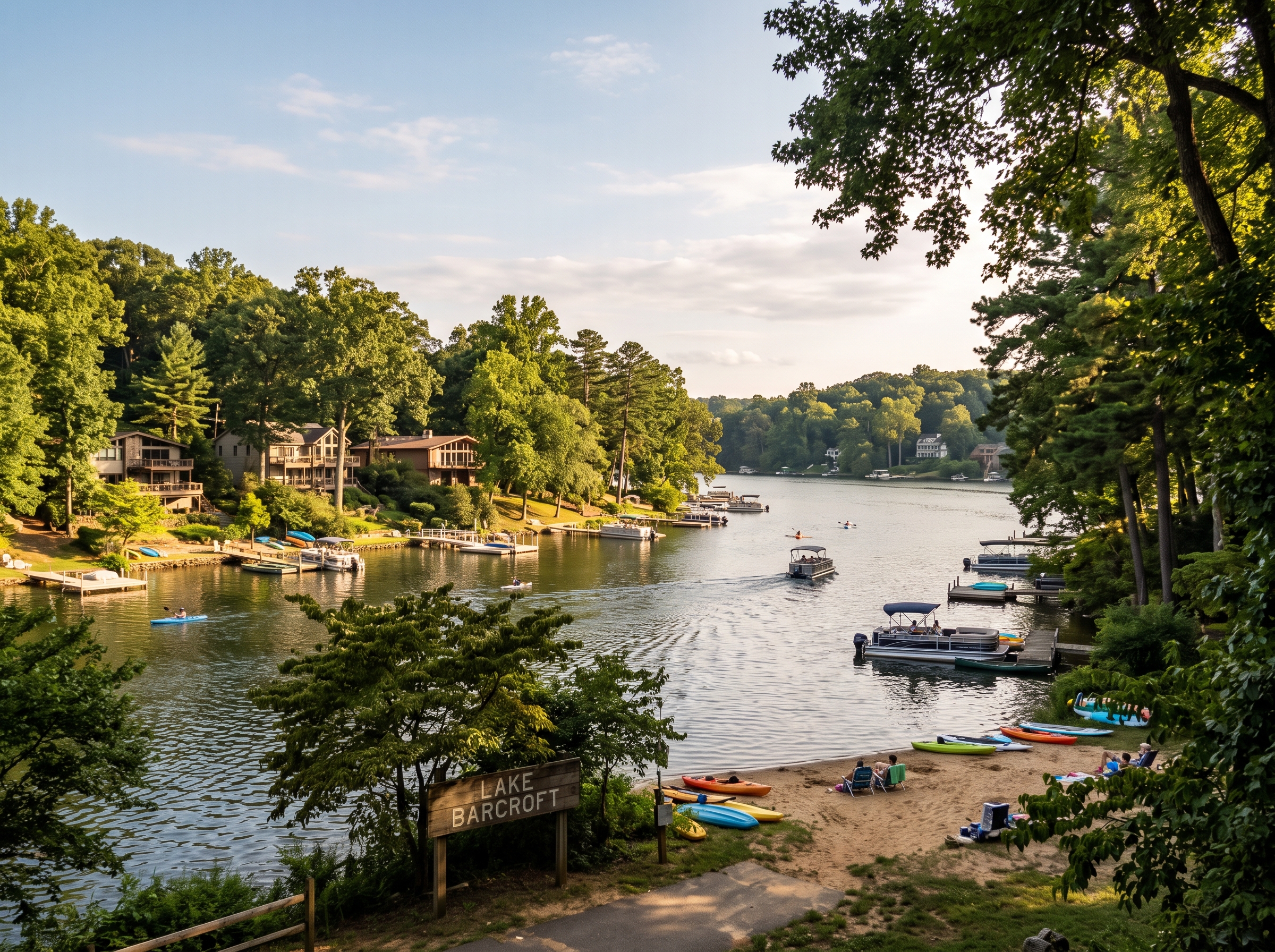
- Exclusive Private Waterfront Enclave: Lake Barcroft is a completely private, 135-acre freshwater lake community containing approximately 1,040 custom homes, situated just seven miles west of Washington, D.C. within the Mason Magisterial District.
- Strict Private Access & Non-Polluting Boating: The lake, shoreline easements, and five white-sand community beaches are private property deeded to the Lake Barcroft Association (LBA). Internal combustion gasoline engines are strictly prohibited, ensuring zero petroleum runoff and whisper-quiet electric pontoon boating, sailing, and kayaking.
- Pioneering Watershed Governance (LBWID): Established in 1973 by the Circuit Court of Fairfax County, the Lake Barcroft Watershed Improvement District was Virginia's first urban watershed conservation district, operating automated Obermeyer dam crest gates, silt catchment basins, and environmental water quality laboratories.
- Mid-Century Modern Architectural Treasury: Built largely between 1951 and 1970, the residential inventory represents a premier collection of authentic Mid-Century Modern (MCM) post-and-beam homes, California Contemporaries, Prairie-style ramblers, and custom waterfront estates integrated into steep, wooded glacial topography.
- Pre-K through Grade 12 IB Academic Pipeline: Served by Fairfax County Public Schools (FCPS), featuring the Justice High School International Baccalaureate (IB) Diploma Programme, Glasgow Middle School (IB MYP), and Belvedere Elementary School (authorized IB Primary Years Programme - PYP).
- Statutory Tax & Assessment Structure: Properties are assessed annually at 100 percent of fair market value under Virginia Code § 58.1-3201 by the Fairfax County Department of Tax Administration, accompanied by a dedicated LBWID special conservation district tax.
1. Spatial Morphology, Boundaries & Topographic Character
Lake Barcroft occupies a singularly unique physical niche within the inner suburban landscape of Northern Virginia. Situated entirely within the Mason Magisterial District of Fairfax County (postal ZIP code 22041), this unincorporated census-designated place (CDP) centers upon a serpentine, 135-acre impoundment fed by the perennial headwaters of Holmes Run and Tripps Run. Encompassing approximately 680 total acres of rolling, heavily forested Piedmont hills, Lake Barcroft is located just seven miles southwest of the National Mall and four miles west of the Pentagon.
The community is bounded by major regional transportation arteries while remaining completely insulated from external traffic through a deliberately planned curvilinear street network with no through-streets:
- North Boundary: State Route 7 (Leesburg Pike) and the bustling commercial hubs of Bailey’s Crossroads and Seven Corners, separated by natural topographical escarpments and dense woodlands.
- East Boundary: Columbia Pike (Route 244) and Sleepy Hollow Road, transitioning toward established residential neighborhoods such as Ravenwood Park and Sleepy Hollow.
- South Boundary: Columbia Pike and the Holmes Run stream valley, connecting downstream toward the City of Alexandria and the Cameron Run watershed.
- West Boundary: Sleepy Hollow Road and Gallows Road, linking directly into the historic town centers of Annandale and Falls Church.
2. Historical Evolution: From Colonial Millseat to Municipal Reservoir and Private Enclave
The historical lineage of Lake Barcroft reflects the convergence of nineteenth-century milling industry, early twentieth-century municipal hydraulic engineering, and mid-century suburban master planning.
Colonial Settlement & The Barcroft Mills
In the eighteenth and nineteenth centuries, the swift, reliable waters of Holmes Run powered several early grain and timber mills. The community derives its permanent name from Dr. John W. Barcroft, a physician, inventor, and entrepreneur who acquired extensive acreage along Holmes Run in the mid-1800s. Dr. Barcroft rebuilt and modernized a substantial grist mill on Columbia Pike that had been damaged during the Civil War. His mill served as a vital agricultural processing facility for farmers throughout Fairfax and Alexandria counties until the close of the nineteenth century.
The Alexandria Water Company Reservoir (1913–1950)
By the turn of the twentieth century, the growing industrial port City of Alexandria faced critical freshwater shortages. In 1913, the privately owned Alexandria Water Company purchased 680 acres along Holmes Run from the Barcroft estate and neighboring landowners. The company constructed a massive earthen and concrete dam across the Holmes Run gorge, creating what was then officially titled the Alexandria Reservoir.
The reservoir impounded over 1.2 billion gallons of freshwater, serving as the primary municipal drinking water source for the City of Alexandria and expanding military installations—including the naval torpedo station and early Pentagon facilities—throughout World War I and World War II. During this municipal phase, the surrounding forested watershed was strictly quarantined to prevent water contamination, preserving an extraordinary virgin canopy of mature white oaks, beech, tulip poplars, and American sycamores that remains largely intact today.
The 1950 Barger-Bready Master Plan & Residential Conversion
Following World War II, explosive population growth in Northern Virginia outstripped the reservoir's capacity. In 1949, the Alexandria Water Company constructed a larger, regional water intake system on the Occoquan River, rendering the Holmes Run reservoir surplus.
Recognizing the extraordinary recreational and residential potential of an intact freshwater lake within minutes of the nation's capital, developers C.W. Barger and J.E. Bready purchased the entire 680-acre property and reservoir in 1950. Renaming the water body Lake Barcroft, Barger and Bready partnered with prominent landscape architects and civil engineers to create a high-end, deed-restricted residential community. The plan platted approximately 1,040 residential homesites, reserving the entire lake surface, shoreline buffer easements, and five strategic sandy beach tracts for the private, perpetual use of community residents.
3. Lake Ecosystem, Water Quality & The Five Private Community Beaches
The heart and defining asset of the community is the 135-acre private freshwater lake. Measuring approximately two miles in length with more than 13 miles of intricately indented shoreline, the lake provides an unparalleled private recreational sanctuary.
| Beach Facility | Location & Shoreline Position | Key Amenities & Infrastructure | Recreational Focus |
|---|---|---|---|
| Beach 1 | South End, Lakeview Drive & Columbia Pike | Large Sand Beach, Swimming Area, Roped Lap Lanes, Shaded Pavilion, Boat Racks | Primary Community Events, Annual Fourth of July Fireworks, Music Concerts |
| Beach 2 | Southeast Shore, Off Waterway Drive | Secluded Sandy Shore, Swim Docks, Shaded Tree Canopy, Kayak Launches | Quiet Family Swimming, Sunset Gatherings, Paddlecraft Launching |
| Beach 3 | Central West Shore, Off Crosswoods Drive | Expansive Sand Beach, Certified Lifeguard Station, Playground, Picnic Tables | Children's Swim Lessons, Neighborhood Playgroups, Beach Volleyball |
| Beach 4 | Northwest Shore, Off Stoneybrae Drive | Sheltered Cove Setting, Grassy Lawns, Sand Beach, Boat Storage Facilities | Tranquil Reading, Paddleboarding, Natural Habitat Observation |
| Beach 5 | North End, Near Holmes Run Delta & Sleepy Hollow | Expansive Parklike Grounds, Sand Shoreline, Picnic Grove, Fishing Points | Community Picnics, Angling, Nature Trails, Environmental Education |
Private Ownership & The Lake Barcroft Association (LBA)
Unlike public lakes operated by federal, state, or county authorities, Lake Barcroft is 100 percent private property. The lakebed, shoreline access rights, and beach facilities are legally held in trust and administered by the Lake Barcroft Association (LBA), a mandatory property owners association governed by an elected resident board of directors.
Access to the lake waters and beaches is strictly limited to Lake Barcroft property owners, registered tenants, and their accompanying guests. Community members must carry official LBA identification cards. During seasonal operating months (Memorial Day through Labor Day), all five community beaches are staffed by professional, certified lifeguards, and the lake is regularly patrolled by the LBA Water Safety boat to enforce swimming and navigation standards.
Non-Polluting Electric Boating & Watercraft Regulations
A cornerstone of Lake Barcroft’s pristine environmental character is its strict prohibition against internal combustion marine engines. Under LBA covenants:
- Gasoline Outboards Prohibited: No hydrocarbon-powered gasoline or diesel engines are permitted to operate on the lake surface at any time, eliminating gasoline slicks, exhaust emissions, underwater acoustic disturbance, and high-speed wake erosion.
- Permitted Watercraft: Residents utilize human-powered watercraft (racing kayaks, sea kayaks, canoes, stand-up paddleboards, rowing shells, and sailboats) or whisper-quiet electric-powered boats.
- Electric Pontoon Culture: Custom electric pontoon boats—equipped with marine deep-cycle battery banks and high-thrust electric outboard or pod-drive motors—are the signature social vehicle of Lake Barcroft, providing leisurely evening cocktail cruises, family outings, and wildlife excursions.
- Registration & Inspection: Every watercraft launched into Lake Barcroft must undergo annual inspection, demonstrate proof of residency, and display an official serialized LBA decal.
4. The Lake Barcroft Watershed Improvement District (LBWID): Engineering & Environmental Stewardship
The long-term ecological stability and flood management of Lake Barcroft are safeguarded by the Lake Barcroft Watershed Improvement District (LBWID). Established in January 1973 by an order of the Circuit Court of Fairfax County following the catastrophic flooding and historic siltation caused by Tropical Storm Agnes in June 1972, the LBWID holds the legal distinction of being the first urban conservation watershed district in the Commonwealth of Virginia.
Legal Structure & Governance
The LBWID operates as a political subdivision of the Commonwealth of Virginia, functioning under the oversight of three publicly elected trustees who reside within the Lake Barcroft community. Unlike voluntary civic committees, the LBWID possesses governmental statutory authority to finance, construct, and maintain public watershed infrastructure. Its annual operating budget and long-range capital reserve funds are financed via a dedicated, special real estate tax assessment itemized on the Fairfax County real estate tax bill of every Lake Barcroft property owner.
Barcroft Dam Operations & Automated Crest Gates
The focal point of LBWID engineering responsibility is the historic Barcroft Dam, a massive concrete and earthen gravity dam anchoring the southern terminal of the lake across Holmes Run. To modernize flood control while maintaining consistent recreational water levels, the LBWID replaced obsolete mechanical bascule gates with state-of-the-art Obermeyer inflatable spillway crest gates.
Operated by sophisticated pneumatic control systems linked to real-time upstream hydrologic sensors throughout the 14-square-mile Holmes Run watershed, the Obermeyer gates automatically adjust to maintain optimal lake elevations. During major Atlantic tropical storms or severe thunderstorms, the system lowers the crest gates, systematically releasing excess floodwaters downstream into Holmes Run to prevent lake overtopping and safeguard lakeside structural foundations from hydrostatic pressure and inundation.
Proactive Siltation Management & Limnological Health
Because Lake Barcroft receives urban runoff from an extensive upstream watershed across Fairfax and Arlington counties, sediment and nutrient loading represent perpetual environmental challenges. The LBWID executes an aggressive, comprehensive limnological management program:
- Sediment Basin Dredging: Specialized deep-water silt catchment basins at the deltas of Holmes Run and Tripps Run capture suspended coarse sediments before they can settle into the main lake basin. The LBWID conducts cyclical hydraulic and mechanical dredging operations, removing tens of thousands of cubic yards of silt to maintain navigational depths.
- Water Quality Monitoring: Staff limnologists conduct bi-weekly laboratory testing of lake water parameters, monitoring dissolved oxygen, turbidity, fecal coliform bacteria, phosphorus, and nitrogen levels to ensure swimming safety and ecological equilibrium.
- Biological Vector Control: To maintain clear swimming corridors without utilizing harsh chemical herbicides, the LBWID employs sterile triploid grass carp for natural aquatic weed control, supplemented by mechanical aquatic weed harvesters and targeted bio-rational treatments.
5. Architectural Typologies, Mid-Century Modernism & Structural Anatomy
Lake Barcroft is celebrated throughout the eastern United States as a premier outdoor museum of post-war residential architecture. Developed during the golden era of American modernism from 1951 through the late 1960s, the community’s approximately 1,040 homesites are characterized by an exceptional concentration of custom Mid-Century Modern (MCM) residences, California Contemporary post-and-beam homes, split-levels, and Prairie-style ramblers.
| Architectural Style | Predominant Construction Era | Key Structural & Exterior Characteristics | Spatial Orientation & Siting |
|---|---|---|---|
| Mid-Century Modern (MCM) Post-and-Beam | 1952 – 1968 | Exposed Timber Posts, Tongue-and-Groove Ceilings, Floor-to-Ceiling Window Walls, Low-Slope Shed Roofs | Sited along Steep Glacial Contours to Maximize Lake Vistas & Canopy Integration |
| California Contemporary | 1955 – 1972 | Open-Plan Living, Clerestory Windows, Native Stone Accents, Multi-Tiered Cedar Sun Decks | Cantilevered over Hillside Topography with Direct Walkout Basement Terraces |
| Prairie-Style Brick Ramblers | 1951 – 1964 | Horizontal Massing, Deep Overhanging Eaves, Roman Brick Masonry, Low-Pitch Hip Roofs | Wide-Frontage Parcels with Generous Front Lawn Setbacks |
| Tri-Level & Split-Foyer Enclaves | 1954 – 1969 | Staggered Functional Living Zones, Masonry Grade-Level Basements, Integrated Garages | Tiered Grading adapting to Undulating Interior Streetscape Contours |
| Custom Modern Luxury Waterfront Rebuilds | 1998 – Present | Steel-Frame Skeletons, Thermally Broken Glass Curtains, Natural Limestone, Sustainable Green Roofs | Prime Shoreline Parcels with Private Docks, Boat Hoists & Bulkhead Landscaping |
The Post-and-Beam Structural System
The custom contemporary homes of Lake Barcroft rely on post-and-beam structural frameworks rather than traditional repetitive dimensional 2x4 stud walls. By concentrating vertical roof and floor loads onto massive glue-laminated (glulam) timber beams and solid wood posts spaced at wide intervals, architects eliminated the need for interior load-bearing partition walls.
This structural anatomy enabled the signature architectural features of the community: soaring open-concept living rooms, cathedral ceilings featuring exposed structural timbers, and continuous non-bearing exterior walls composed entirely of structural insulating glass panels that blur the boundary between indoor living spaces and the surrounding forest.
Technical Property Inspections & Environmental Retrofitting
Prospective purchasers and owners of mid-century residences in Lake Barcroft must consider several unique maintenance and engineering dynamics inherent to hillside waterfront properties:
- Hillside Foundation Hydrodynamics: Homes built into steep slopes utilize stepped concrete masonry unit (CMU) or poured concrete daylight basement foundations. Owners must ensure proper functioning of foundation perimeter footing drains, gravel backfill, and gravity-fed swales to relieve hydrostatic pressure caused by natural downhill groundwater migration toward the lake.
- Low-Slope & Flat Roof Membranes: Original built-up gravel roofs have universally transitioned to modern single-ply elastomeric membranes, such as ethylene propylene diene monomer (EPDM) or heat-welded thermoplastic polyolefin (TPO). Inspections must focus on scupper drains, parapet flashing, and positive drainage slope to prevent ponding water beneath heavy deciduous tree canopies.
- Thermal Envelope Modernization: Mid-century glass walls originally featured single-pane annealed plate glass. Modern property conservation involves retrofitting frames with thermally broken structural aluminum or architectural steel systems housing dual-pane low-emissivity (Low-E), argon-insulated glass units, drastically cutting heating/cooling loads while preserving clean, minimalist sightlines.
- Shoreline Riprap & Bulkhead Maintenance: Direct waterfront properties must maintain stable, permitted riprap stone revetments or marine-grade timber bulkheads under LBA and Fairfax County environmental guidelines to prevent wave and storm runoff erosion along the water's edge.
6. Public Education Infrastructure: FCPS School Pyramids & Academic Profiles
Lake Barcroft is served by Fairfax County Public Schools (FCPS), recognized nationally for academic rigor and student achievement. The community benefits from an exceptional, coherent pre-kindergarten through grade 12 International Baccalaureate (IB) educational pipeline centered on the Justice High School Pyramid.
| School Facility | Grade Levels | Academic Pyramidal Alignment | Curriculum Specializations & Academic Honors |
|---|---|---|---|
| Justice High School | Grades 9 – 12 | Justice Pyramid | Authorized International Baccalaureate (IB) World School, Full IB Diploma Programme, Advanced Placement Options |
| Glasgow Middle School | Grades 6 – 8 | Justice Pyramid | Authorized IB Middle Years Programme (MYP), Accelerated Algebra & Geometry Tracks, World Languages |
| Belvedere Elementary School | Pre-K – Grade 5 | Justice Pyramid | Authorized IB Primary Years Programme (PYP) World School, Advanced Academic Programs (AAP), Environmental Focus |
| Sleepy Hollow Elementary | Pre-K – Grade 5 | Justice Pyramid | Advanced Academic Programs (AAP), STEAM Initiatives, Integrated Project-Based Science Learning |
| Bailey’s Elementary Arts & Sciences | Pre-K – Grade 2 | Mason District Magnet | Fairfax County Magnet School for the Arts & Sciences, Integrated Engineering Labs, Spanish Immersion |
The International Baccalaureate (IB) Continuum: Belvedere to Justice High
Lake Barcroft families enjoy access to a rare, continuous International Baccalaureate framework:
- Belvedere Elementary (IB PYP): As an authorized IB Primary Years Programme school, Belvedere instills interdisciplinary inquiry, multilingual global perspectives, and ecological stewardship beginning in kindergarten.
- Glasgow Middle (IB MYP): Bridges elementary learning with middle school academic rigor through the eight subject groups of the IB Middle Years Programme, offering high-school credit courses in Algebra, Geometry, Spanish, and French.
- Justice High School (IB Diploma Programme): An authorized IB World School, Justice High offers the prestigious two-year IB Diploma Programme for eleventh and twelfth graders. Students engage in rigorous college-level seminars, complete independent laboratory research, author a 4,000-word Extended Essay, and participate in the Theory of Knowledge (TOK) capstone course, qualifying for substantial advanced standing at premier universities nationwide.
Advanced Academic Programs (AAP) & Thomas Jefferson High School (TJHSST) Access
Lake Barcroft students identified for gifted education services have access to Full-Time Advanced Academic Programs (AAP Level IV). Furthermore, rising eighth-grade students residing in Lake Barcroft are eligible to apply for admission to Thomas Jefferson High School for Science and Technology (TJHSST) in neighboring Lincolnia. Consistently ranked as the number one public STEM high school in the United States, TJHSST features advanced research laboratories in robotics, microelectronics, optics, and biotechnology.
7. Transportation Logistics, Highway Arterials & Commuter Corridors
Despite its peaceful, lakefront retreat ambiance, Lake Barcroft offers extraordinary proximity to the primary commercial, military, and federal employment complexes of the Washington metropolitan region.
Primary Commuter Highways
- Columbia Pike (State Route 244): Bordering the southern edge of the community, Columbia Pike provides a direct, uninterrupted east-west artery through Arlington directly into the Pentagon, the Pentagon City / Crystal City National Landing tech campus (including Amazon HQ2), and the 14th Street Bridge into Washington, D.C.
- US Route 50 (Arlington Boulevard): Accessible within three minutes via Sleepy Hollow Road or George Mason Drive, Route 50 provides multi-lane grade-separated freeway transit eastward across the Theodore Roosevelt Memorial Bridge directly into Constitution Avenue, the State Department, and downtown D.C.
- State Route 7 (Leesburg Pike): Situated immediately north, Route 7 connects Lake Barcroft northwestward to the independent City of Falls Church and the commercial skyscrapers of Tysons, and southeastward to Interstate 395 and historic Old Town Alexandria.
- Interstate 395 (Shirley Highway): Located approximately two miles southeast via King Street or Seminary Road, I-395 provides rapid interstate transit south to Springfield and Quantico, and north to Capitol Hill.
Public Transit & Dedicated Bus Corridors
Lake Barcroft commuters benefit from robust public transit options:
- Metrobus 16M (Columbia Pike Line): Operating along Columbia Pike, the 16M is a premier, high-frequency transit line featuring articulated low-floor buses and transit signal priority, providing rapid one-seat service directly to the Pentagon Metrorail Station (Blue and Yellow Lines) and Pentagon City.
- Metrorail Station Proximity: Lake Barcroft is strategically situated within 10 to 12 minutes of multiple Metrorail stations, including East Falls Church Station (Orange and Silver Lines), Ballston-MU Station (Orange and Silver Lines), and King Street-Old Town Station (Blue and Yellow Lines).
8. Environmental Topography, Geology & Protected Regional Parklands
The natural setting of Lake Barcroft is shaped by its location along the Fall Line, the geological interface where the crystalline, ancient bedrock of the Piedmont Province gives way to the coastal sediment of the Atlantic Coastal Plain. Holmes Run has carved a deep, dramatic gorge through metamorphic schist and granitic bedrock, creating the rugged ravines, rocky rapids, and forested bluffs that enclose the lake.
Flora & Faunal Biodiversity
Because the lake perimeter was protected from deforestation during its four decades as a municipal reservoir, Lake Barcroft boasts an exceptionally rich native ecosystem. The mature forest canopy comprises massive white oaks, northern red oaks, American beech, tulip poplars, black walnuts, and sweetgum trees, underplanted with native mountain laurel, flowering dogwoods, and ferns.
This protected freshwater habitat supports a thriving wildlife population:
- Avian Species: Resident pairs of bald eagles, ospreys, great blue herons, green herons, belted kingfishers, cormorants, and wood ducks breed and hunt along the shoreline. Lake Barcroft serves as an essential migratory stopover for northern waterfowl along the Atlantic Flyway.
- Limnological & Aquatic Life: The lake supports healthy populations of largemouth bass, black crappie, bluegill sunfish, channel catfish, yellow perch, and freshwater river otters. Strict catch-and-release sports fishing by residents is actively encouraged by the LBA.
Adjacent Regional Parks & Stream Valley Corridors
- Holmes Run Stream Valley Park: Extending both upstream and downstream from the Barcroft Dam, this continuous Fairfax County and Alexandria park system offers miles of paved and natural hiking trails winding through scenic riparian woodlands alongside boulder-strewn rapids.
- Roundtree Park & J.E.B. Stuart Park: Nearby community parks offering tennis courts, athletic fields, picnic facilities, and children's play areas.
- Upton's Hill Regional Park: Located just two miles north on the Arlington border, offering swimming complexes, batting cages, and woodland climbing adventures.
9. Real Estate Assessment Cycles, LBWID Levies & Virginia Tax Code
Real estate taxation in Lake Barcroft operates under the statutory framework of the Commonwealth of Virginia and the administrative authority of Fairfax County. Because Lake Barcroft is an unincorporated community within Fairfax County, property owners pay municipal taxes solely to the County, with zero supplemental city-level real estate taxes.
Virginia Code Title 58.1-3201: The 100% Fair Market Value Mandate
Under Virginia Code § 58.1-3201, all real property in Virginia must be assessed for tax purposes at one hundred percent (100%) of its true fair market value. The Fairfax County Department of Tax Administration (DTA) conducts comprehensive annual reassessments of every taxable parcel in Lake Barcroft. Valuations are based on verified arm's-length sales of comparable properties within specific neighborhood market codes, taking into account lot size, topography, structural improvements, and whether a parcel enjoys direct shoreline water frontage or secondary water views.
The Dedicated LBWID Conservation District Tax Line
A distinctive statutory feature of property ownership in Lake Barcroft is the Lake Barcroft Watershed Improvement District (LBWID) Special Tax. Itemized directly on the official Fairfax County real estate tax bill, this dedicated millage rate is levied on all real property within the boundaries of the district. The revenue generated by this statutory tax is transferred directly to the LBWID to fund:
- Operational maintenance and capital reserve funding for the Barcroft Dam and Obermeyer inflatable spillway gates.
- Continuous mechanical and hydraulic dredging of the silt catchment basins at the deltas of Holmes Run and Tripps Run.
- Routine water quality testing, limnological research, and biological vector control.
- Shoreline stabilization and emergency flood mitigation operations.
Annual Assessment Calendar & Payment Schedules
- January 1 (Statutory Effective Date): Property assessments are legally established as of January 1 of each calendar year, reflecting real estate market transactions occurring during the preceding twelve months.
- Late February (Assessment Notices Mailed): The DTA mails official Notice of Real Estate Assessment cards to all property owners, itemizing land value, building value, and total taxable assessment.
- Semi-Annual Payment Deadlines: Real estate tax payments in Fairfax County are billed in two equal installments:
- First Installment: Statutorily due on or before July 28.
- Second Installment: Statutorily due on or before December 5.
Statutory Assessment Appeals Mechanism
Property owners who believe their annual assessment exceeds fair market value, is non-uniform compared to contiguous properties, or contains clerical errors have the legal right to challenge the assessment through a formal two-tiered process:
- Administrative Review: An informal appeal submitted directly to the Department of Tax Administration, typically required by early April. An assigned county residential appraiser reviews structural data, square footage calculations, physical property condition, and relevant sales comps.
- Board of Equalization (BOE) Appeal: A formal evidentiary appeal submitted to the citizen-led Board of Equalization of Real Estate Assessments, typically requiring filing by June 1. If dissatisfied with the BOE ruling, property owners retain the statutory right to file a petition with the Circuit Court of Fairfax County under Virginia Code § 58.1-3984.
10. Frequently Asked Questions Regarding Lake Barcroft, VA Real Estate
Is Lake Barcroft a public lake or a private community?
Lake Barcroft is a strictly private community. The 135-acre lake, its surface waters, shoreline easements, and five white-sand community beaches are private property owned and managed by the Lake Barcroft Association (LBA). Access is restricted exclusively to Lake Barcroft residential property owners and their registered guests. There is no public boat ramp or recreational access for non-residents.
What are the boating and watercraft regulations on Lake Barcroft?
To preserve water clarity, prevent petroleum pollution, and protect community tranquility, internal combustion gasoline engines are strictly prohibited on Lake Barcroft. Boating is restricted to human-powered craft (canoes, kayaks, paddleboards, rowboats, sailboats) and electric-powered watercraft (such as electric pontoon boats and electric launches). All boats must be registered with the Lake Barcroft Association and display official LBA decals.
What is the historical origin of Lake Barcroft?
The lake originated in 1913 when the Alexandria Water Company constructed a dam on Holmes Run to create a drinking water reservoir, named after Dr. John W. Barcroft, a prominent 19th-century inventor and local mill operator. The reservoir supplied municipal water to Alexandria and federal facilities during World War I and World War II. In 1950, when the water company relocated its primary intake to the Occoquan, developers Barger-Bready purchased the 680-acre tract and transformed the reservoir into a private master-planned residential lake community.
What is the Lake Barcroft Watershed Improvement District (LBWID)?
Established in 1973 by the Circuit Court of Fairfax County following the severe siltation caused by Tropical Storm Agnes, the Lake Barcroft Watershed Improvement District (LBWID) was the first urban conservation watershed district in the Commonwealth of Virginia. Governed by three elected trustees and funded via a dedicated line item on residents' real estate tax bills, the LBWID is responsible for water quality testing, routine sediment dredging, shoreline stabilization, and the operation and maintenance of the Barcroft Dam spillway gates.
What architectural styles predominate in Lake Barcroft?
Lake Barcroft is nationally renowned for its custom Mid-Century Modern (MCM) residential architecture, California Contemporary post-and-beam homes, split-levels, and low-slung Prairie-style ramblers constructed between 1951 and 1970. Homes typically feature expansive floor-to-ceiling glass fenestration, cathedral tongue-and-groove timber ceilings, exposed native stone chimney masses, and generous multi-tiered cedar decks engineered to harmonize with steep, forested lakeside contours.
How many beaches are there in Lake Barcroft and what amenities do they offer?
Lake Barcroft features five private white-sand community beaches, designated Beaches 1 through 5. Each beach offers roped swimming areas with certified lifeguards during summer operating seasons, shaded picnic pavilions, boat storage racks, playground equipment, and community gathering spaces that host neighborhood concerts, Fourth of July festivities, and environmental workshops.
Which public schools serve the Lake Barcroft community?
Lake Barcroft is served by Fairfax County Public Schools (FCPS) within the Justice High School pyramid. High school students attend Justice High School, an authorized International Baccalaureate (IB) World School offering the prestigious IB Diploma Programme. Middle school students attend Glasgow Middle School (IB Middle Years Programme), and elementary students are zoned to Belvedere Elementary School (an authorized IB Primary Years Programme school) or Sleepy Hollow Elementary, with access to Bailey's Elementary Arts and Sciences Magnet.
What are the commuter connections from Lake Barcroft to Washington, D.C.?
Lake Barcroft is located approximately seven to eight miles from downtown Washington, D.C. Commuters utilize Columbia Pike (Route 244) or US Route 50 (Arlington Boulevard) for direct access to the Pentagon, Crystal City/National Landing, and downtown D.C. In addition, express Metrobus service—including the 16M Columbia Pike line—provides frequent one-seat transit connectivity to the Pentagon Metrorail Station (Blue and Yellow Lines).
How does the Barcroft Dam manage water levels and flood events?
The Barcroft Dam across Holmes Run incorporates automated inflatable Obermeyer spillway crest gates. Controlled by the LBWID, these pneumatically operated gates allow precise regulation of the lake’s water elevation, ensuring consistent lake levels for recreation while providing automated rapid lowering during severe precipitation events to safely manage floodwaters without impacting lakeside structural foundations.
How are real estate assessments and taxes structured in Lake Barcroft?
Properties in Lake Barcroft are assessed annually at 100 percent of fair market value by the Fairfax County Department of Tax Administration under Virginia Code § 58.1-3201. Real estate tax bills are paid semi-annually on July 28 and December 5. In addition to the Fairfax County general levy and stormwater service district tax, Lake Barcroft properties include a dedicated special tax levy that exclusively funds the operational and capital reserves of the Lake Barcroft Watershed Improvement District (LBWID).
11. Academic References, Limnological Archives & Statutory Legal Disclaimers
This architectural monograph, limnological review, and real estate reference treatise incorporates verified historical archives, public planning documents, and statutory legal frameworks:
- Lake Barcroft Watershed Improvement District (LBWID): Comprehensive Watershed Management Plan, Annual Dam Safety Inspections & Water Quality Reports, Falls Church, Virginia.
- Fairfax County Comprehensive Plan: Area I, Annandale and Baileys Planning Districts, Environmental Quality Corridors (EQCs) and Lake Barcroft Policy Guidance, Fairfax County Department of Planning and Development, Fairfax, Virginia.
- Virginia Department of Conservation and Recreation (DCR): Division of Dam Safety and Floodplain Management, Barcroft Dam (Inventory #059001) Certification Records, Richmond, Virginia.
- Fairfax County Public Schools (FCPS): Office of Facilities Planning, Justice High School, Glasgow Middle, and Belvedere Elementary Feeder Architecture, Gatehouse Administration Center, Falls Church, Virginia.
- Code of Virginia (Statutory Authority): Title 58.1 (Taxation), § 58.1-3201 (Fair Market Value Mandates) and Title 10.1 (Conservation), Chapter 6, Article 2 (Watershed Improvement Districts), Commonwealth of Virginia, Richmond, Virginia.
- United States Geological Survey (USGS): Annandale and Falls Church 7.5-Minute Topographic Quadrangles, Holmes Run Hydrologic Basin and Fall Line Geology, Reston, Virginia.
Statutory Research & Regulatory Notice: This architectural monograph, limnological reference, and submarket treatise is published strictly for informational, educational, and spatial orientation purposes. Real estate boundaries, lake covenant regulations, school attendance zones, watercraft licensing rules, and tax assessment schedules are subject to ongoing administrative modifications by the Fairfax County Board of Supervisors, the Lake Barcroft Association (LBA), the Lake Barcroft Watershed Improvement District (LBWID), and the Fairfax County School Board. This publication does not constitute formal appraisal valuations, structural architectural inspections, or legal counsel. Prospective purchasers and property owners must verify official parcel-specific records and deed restrictions directly with the Lake Barcroft Association and the Fairfax County Department of Tax Administration (DTA).