
Seven Corners, VA Real Estate: The Definitive Guide to Spatial Morphology, CBC Revitalization, Historic Fortifications & Residential Enclaves
Executive Summary & Essential Community Takeaways
- Strategic Regional Gateway: Situated at the tripartite juncture of Fairfax County, Arlington County, and the City of Falls Church, Seven Corners provides non-stop vehicular and express bus transit to Rosslyn, the Pentagon, and downtown Washington, D.C.
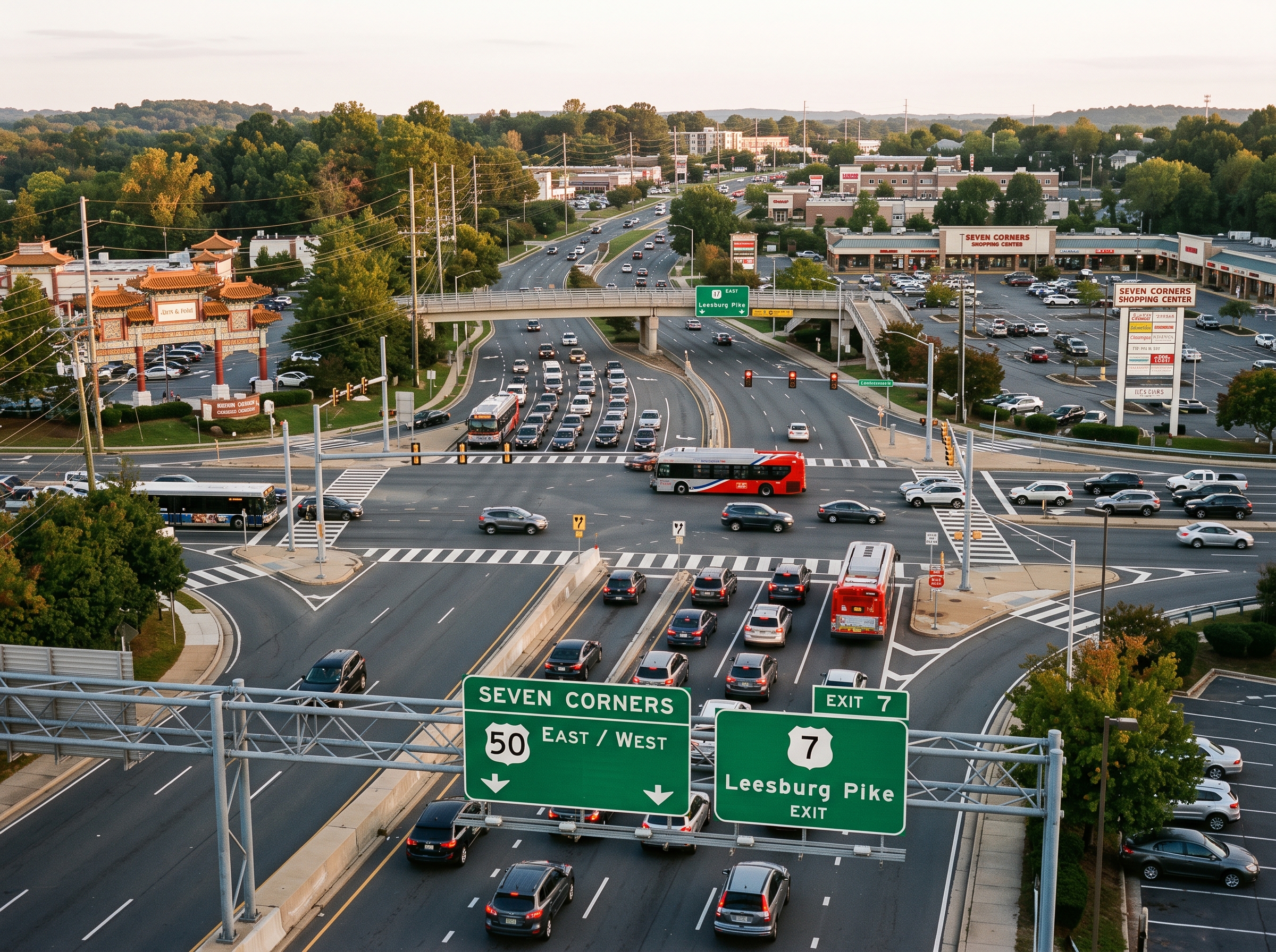
- Seven-Way Junction Morphology: Formed by the convergence of US Route 50 (Arlington Boulevard), State Route 7 (Leesburg Pike), State Route 338 (Hillwood Avenue), Wilson Boulevard, and Sleepy Hollow Road.
- Seven Corners CBC & Ring Road Vision: Under the Fairfax County Comprehensive Plan, the 285-acre Community Business Center (CBC) is planned to transition from automobile superblocks to a walkable urban street grid anchored by a four-lane circulatory Ring Road and dedicated transitways.
- Preserved Mid-Century Enclaves: Secluded residential subdivisions—such as Ravenwood Park and Sleepy Hollow—feature preserved 1950s brick ramblers, split-levels, and custom mid-century modern residences sheltered beneath mature hardwood canopies.
- High-Performing Dual School Pyramids: Residential parcels feed into Fairfax County Public Schools (FCPS), anchored by the Justice High School International Baccalaureate (IB) World School pyramid and the modernized Falls Church High School campus.
- Statutory Assessment Protections: Property valuations follow Virginia Code Title 58.1-3201 statutory 100 percent fair market value standards administered through annual Department of Tax Administration (DTA) equalization cycles.
1. Spatial Morphology, Boundaries & Regional Context
Seven Corners represents one of the most structurally consequential suburban nodes in the Washington metropolitan area. Situated in the eastern portion of Fairfax County within the Mason Magisterial District, this unincorporated census-designated place (postal ZIP code 22044) occupies the exact geographic intersection where Fairfax County converges with Arlington County and the independent municipality of the City of Falls Church.
Topographically elevated atop Munson’s Hill at elevations approaching 400 feet above sea level, Seven Corners commands panoramic lines of sight east toward the Potomac River basin, Theodore Roosevelt Island, and the monumental core of Washington, D.C. The community's physical footprint is bounded by:
- Northwest Boundary: The City of Falls Church corporate line, following the historic alignment of State Route 338 (Hillwood Avenue) and South Washington Street.
- Northeast Boundary: Arlington County, bordering the residential neighborhoods of Boulevard Manor, Dominion Hills, and Upton’s Hill Regional Park along McKinley Road and Wilson Boulevard.
- South Boundary: Sleepy Hollow Road, transitioning into the stream valley parklands of Tripps Run, the residential acreage of Ravenwood Park, and the private shoreline of Lake Barcroft.
- West Boundary: Graham Road and the suburban residential developments of Raymondale and Westlawn, linking westward toward the Annandale and Merrifield submarkets.
2. Historical Evolution: Colonial Turnpikes, Civil War Fortifications & The 1956 Commercial Revolution
The historical trajectory of Seven Corners spans two centuries of infrastructure engineering, military tactical defense, and pioneering post-war retail development.
Colonial Era Turnpikes & Overland Commerce (1813–1860)
Long before modern highways were paved, Seven Corners originated as a natural ridgeline junction. In February 1813, the Virginia General Assembly chartered the Alexandria and Leesburg Turnpike Company to construct a paved toll road connecting the agricultural hinterlands of Loudoun County and the Shenandoah Valley to the maritime wharves of Alexandria on the Potomac River. As intersecting trails from Falls Church, Georgetown, and Annandale joined the turnpike across the crest of Munson’s Hill, seven distinct road approaches emerged, giving the crossroads its lasting identity.
The Civil War & The Legend of the "Quaker Guns" (1861–1865)
Following the Confederate victory at the First Battle of Manassas in July 1861, Confederate divisions commanded by General James Longstreet and cavalry units led by Colonel J.E.B. Stuart pushed east into Fairfax County, seizing the high ground at Munson’s Hill and neighboring Upton’s Hill. From this commanding promontory, Confederate lookouts easily observed the unfinished dome of the United States Capitol and tracked federal troop movements throughout the District of Columbia.
Lacking sufficient heavy field artillery to defend the hilltop against a determined Union counter-offensive, Confederate troops engineered a brilliant tactical deception. They felled trees, cut logs to the dimensions of 32-pounder siege cannons, painted them glossy black, and fitted them with discarded iron stovepipes to simulate weapon muzzles. Placed prominently along the earthen parapets, these "Quaker Guns" deceived Union military balloonist Professor Thaddeus Lowe and Union reconnaissance officers for over six weeks, successfully halting Union offensive operations until the Confederate army conducted an orderly planned withdrawal westward to Centerville in late September 1861.
When Union forces under General George B. McClellan advanced to occupy the abandoned fortifications, journalists and soldiers discovered the wooden logs, generating nationwide press coverage. Union forces fortified the position permanently, constructing Fort Buffalo at the junction of Leesburg Pike and Sleepy Hollow Road. Named after the 21st New York Infantry Regiment, Fort Buffalo was fitted with real heavy artillery, a military telegraph station, and an earthwork redoubt that defended the western approaches to Washington throughout the Civil War.
The 1956 Shopping Center: Northern Virginia’s Modern Commercial Birth
In the decade following World War II, real estate developers Kass-Berger recognized that suburban expansion along US Route 50 created unprecedented demand for centralized commercial amenities. In October 1956, Kass-Berger opened the Seven Corners Shopping Center, an architectural and retail milestone designed by celebrated commercial architect Lathrop Douglass.
Encompassing over 600,000 square feet across two levels, the center featured pioneering engineering, including a dramatic hyperbolic paraboloid concrete roof, integrated outdoor pedestrian courtyards, and surface parking for thousands of vehicles. Most notably, the center was anchored by the mid-Atlantic's two premier luxury department stores: Julius Garfinckel & Co. and Woodward & Lothrop ("Woodies"). Opening twelve years before Tysons Corner Center, Seven Corners established itself as Northern Virginia’s primary luxury shopping destination, precipitating the rapid residential conversion of surrounding agricultural acreage.
3. Residential Enclaves, Neighborhood Typologies & Architectural Anatomy
While Seven Corners is internationally known for its retail and transit corridors, its residential core comprises quiet, deeply wooded neighborhoods that offer some of the most stable, mature architectural housing in inner Fairfax County.
| Subdivision / Community Enclave | Primary Architectural Style | Construction Era | Typical Lot Dimensions | Zoning Classification |
|---|---|---|---|---|
| Ravenwood Park | Solid Brick Ramblers & Split-Levels | 1950 – 1968 | 0.25 to 0.50 Acre Lots | R-3 / R-4 (Single-Family Residential) |
| Sleepy Hollow / Sleepy Hollow Woods | Mid-Century Modern, Prairie Ramblers | 1952 – 1972 | 0.33 to 0.75 Acre Wooded Parcels | R-2 / R-3 (Low-Density Residential) |
| Woodlake Towers Condominiums | Reinforced Concrete High-Rise (15 Stories) | 1971 | Multi-Acre Parklike Campus | R-30 (High-Density Multi-Family) |
| Raymondale & Westlawn (Border) | Post-War Cape Cods & Brick Cottages | 1948 – 1962 | 0.18 to 0.28 Acre Traditional Lots | R-4 (Suburban Single-Family) |
| Peyton Randolph & Cavalier Club | Multi-Level Traditional Brick Townhomes | 1974 – 1986 | Compact Platted Townhome Lots | R-12 / R-16 (Medium Density PUD) |
| The Jefferson Residential Enclave | Mid-Rise Condominiums & Senior Residences | 1985 – 1995 | Integrated Urban Living Campus | R-20 / R-30 (Multi-Family Residential) |
Ravenwood Park: Established Mid-Century Wooded Elegance
Platted between 1950 and 1968 along the rolling hills bordering Sleepy Hollow Road and Tripps Run, Ravenwood Park is celebrated for its substantial solid-brick ramblers and multi-level split-foyer residences. Properties enjoy generous setbacks, wide front frontages, and mature oak, tulip poplar, and hickory trees. The neighborhood is particularly prized for its active civic association, quiet interior cul-de-sacs, and absence of cut-through traffic, providing a tranquil woodland sanctuary within minutes of the Seven Corners commercial district.
Sleepy Hollow: Authentic Mid-Century Modernism
Extending southward from Seven Corners toward Lake Barcroft, the Sleepy Hollow residential enclave is recognized across Virginia as an architectural showcase of custom Mid-Century Modern (MCM) residences. Built by prominent mid-century builders and architects, these homes feature open post-and-beam construction, low-pitch shed rooflines, floor-to-ceiling glass window walls that integrate interior living rooms with private forest vistas, and massive indigenous fieldstone chimney masses.
Woodlake Towers Condominiums: High-Rise Parkside Living
Situated along South Manchester Street directly overlooking the protected parklands of Tripps Run, Woodlake Towers comprises twin 15-story residential towers constructed in 1971. Built using poured-in-place reinforced concrete flat-plate construction, the community offers extraordinary acoustic privacy, spacious private balconies, panoramic views of the Arlington and Washington skylines, two community swimming pools, fitness centers, tennis courts, and on-site retail services. Woodlake Towers provides an established, attainable multi-family ownership opportunity in a parklike setting.
4. Structural Anatomy, Building Eras & Property Maintenance
Purchasing or maintaining real estate in Seven Corners requires specialized technical knowledge of the structural assemblies, plumbing systems, and building codes that governed Northern Virginia construction during the mid-to-late twentieth century.
Single-Family Mid-Century Structural Assemblies (1950–1970)
- Foundations: Primarily unreinforced concrete masonry unit (CMU) block or poured concrete crawl spaces, with full or partial daylight basements on sloping topography. Subsurface waterproofing requires functioning exterior gutters, downspout extensions discharging away from foundation perimeters, and periodic inspection for efflorescence or hairline settlement cracking.
- Framing & Roof Trusses: Dimensional lumber framing utilizing true 2x4 framing studs, 2x8 or 2x10 floor joists, and site-built rafter roof assemblies sheathed in solid 1x6 pine boards. Roof pitches are typically low (3:12 to 5:12), requiring high-performance architectural asphalt shingles or metal standing-seam roofing.
- Electrical Service Infrastructure: Original installations often featured 60-amp or 100-amp split-bus electrical panels with cloth-covered copper branch wiring. Modern residential ownership necessitates upgrading to 200-amp service panels with arc-fault (AFCI) and ground-fault (GFCI) protection to support modern consumer electronics, heat pumps, and electric vehicle (EV) charging stations.
- Plumbing Supply & Drainage: Original supply lines were typically Type L copper or galvanized iron piping. Waste stacks utilized heavy cast iron pipe. Over decades of service, underground cast iron sewer laterals can suffer from interior rust scaling or root infiltration, making fiber-optic video camera sewer scope inspections an essential due-diligence procedure prior to property acquisition.
High-Rise Concrete Structural Dynamics (e.g., Woodlake Towers)
- Structural Integrity: Reinforced cast-in-place concrete columns and post-tensioned floor slabs provide superior structural fire ratings and exceptional impact insulation class (IIC) acoustic isolation.
- Centralized HVAC & Mechanical Systems: Commercial cooling towers, gas-fired boilers, and hydronic fan-coil distribution networks are managed centrally by the condominium association. Owners must review the condominium association’s Reserve Study to verify adequate capital funding for scheduled chiller, boiler, elevator, and facade caulking capital projects.
5. Fairfax County Comprehensive Plan: The Seven Corners CBC & The Ring Road Vision
The long-term development of Seven Corners is directed by the Fairfax County Comprehensive Plan (Area I, Seven Corners Community Business Center). Adopted following extensive community engagement by the Seven Corners Task Force, the plan provides a multi-decade blueprint to transform the 285-acre commercial core into a walkable, transit-oriented, mixed-use community center.
Commercial Revitalization District (CRD) Zoning Incentives
Seven Corners is an official Fairfax County Commercial Revitalization District. This special zoning designation establishes regulatory flexibility designed to incentivize high-quality urban redevelopment:
- Floor Area Ratio (FAR) Enhancements: Developers can achieve increased commercial and residential densities by assembling contiguous parcels, integrating active ground-floor retail, and constructing structured or subgrade parking facilities.
- Pedestrian-Oriented Streetscape Standards: Mandatory wide concrete sidewalks, continuous street tree canopies, human-scale pedestrian lighting, and outdoor dining plazas replacing asphalt parking aprons.
- Workforce & Affordable Housing Mandates: New multi-family residential developments must comply with Fairfax County’s Workforce Dwelling Unit (WDU) and Affordable Dwelling Unit (ADU) policies, guaranteeing dedicated attainable housing options within the revitalization district.
The Ring Road Infrastructure Transformation
The most transformative infrastructure proposal in the Comprehensive Plan is the Seven Corners Ring Road. Engineered to resolve the notorious congestion of the 1950s cloverleaf and flyover interchange, the Ring Road concept establishes a balanced, four-lane circulatory loop around the core commercial superblocks.
- Deconstruction of Congested Flyovers: Eliminates confusing high-speed ramp configurations and hazardous pedestrian crossings.
- Local Street Grid Reconnection: Extends Juniper Street, 6th Street, and Thorne Road to establish a predictable urban grid, dispersing vehicular traffic evenly across signalized intersections.
- Dedicated Multi-Modal Bicycle Promenades: Implements continuous, physically separated cycle tracks and shared-use paths connecting directly to regional trail networks in Arlington and Falls Church.
- Opportunity Area Infill: Unlocks massive commercial superblocks—including Seven Corners Center and Willston Center—for phased redevelopment into walkable town centers featuring community greens, civic centers, and mixed-income residential buildings.
6. Public Education Infrastructure: FCPS School Pyramids & Academic Profiles
Properties in Seven Corners are served by Fairfax County Public Schools (FCPS), consistently ranked among the premier public school systems in the United States. Due to Seven Corners’ unique position across magisterial and historical planning districts, residential neighborhoods feed into two distinguished high school pyramids: the Justice High School Pyramid and the Falls Church High School Pyramid.
| School Facility | Grade Levels | Pyramidal Alignment | Curriculum Specializations & Academic Honors |
|---|---|---|---|
| Justice High School | Grades 9 – 12 | Justice Pyramid | Authorized International Baccalaureate (IB) World School, IB Diploma Programme, AVID, Dual Enrollment |
| Falls Church High School | Grades 9 – 12 | Falls Church Pyramid | Comprehensive Modernization, Advanced Placement (AP), STEM Academy, CAD & Engineering Labs |
| Glasgow Middle School | Grades 6 – 8 | Justice Pyramid | International Baccalaureate Middle Years Programme (MYP), Accelerated Mathematics Tracks |
| Luther Jackson Middle School | Grades 7 – 8 | Falls Church Pyramid | Engineering & Robotics Labs, Honors Curriculum, Extensive Performing Arts Ensembles |
| Sleepy Hollow Elementary | Pre-K – Grade 5 | Justice Pyramid | Advanced Academic Programs (AAP), STEAM Labs, Environmental Stewardship Curricula |
| Beech Tree Elementary | Pre-K – Grade 5 | Justice Pyramid | Full-Time Level IV AAP Center, Eco-Schools USA Green Flag Award, Literacy Specialization |
| Glen Forest Elementary | Pre-K – Grade 5 | Justice Pyramid | Global Classroom Programs, Talent Development Services, Multilingual Immersion Support |
| Bailey’s Elementary Arts & Sciences | Pre-K – Grade 2 | Mason District Magnet | Countywide Magnet School for the Arts and Sciences, Integrated STEM Engineering Curricula |
The International Baccalaureate (IB) Diploma at Justice High
Justice High School is an authorized International Baccalaureate (IB) World School, offering one of Northern Virginia’s most rigorous pre-university courses of study. Juniors and seniors participating in the IB Diploma Programme complete collegiate-level interdisciplinary courses in literature, world languages, experimental sciences, mathematics, and the arts. Students produce an independent 4,000-word Extended Essay and complete the signature Theory of Knowledge (TOK) philosophy seminar, earning competitive undergraduate course credits at leading national colleges and universities.
Falls Church High School Phased Modernization
Serving the western sectors of Seven Corners, Falls Church High School has undergone a multi-year, multi-phase comprehensive capital renewal project. The modernized facility features state-of-the-art biological and physical science research laboratories, acoustically isolated band and choral suites, expanded visual arts studios, a state-of-the-art media center, and upgraded athletics stadiums.
Advanced Academic Programs (AAP) & Thomas Jefferson High School (TJHSST)
Eligible elementary students in Seven Corners have direct access to FCPS Full-Time Advanced Academic Programs (AAP Level IV) hosted at Beech Tree Elementary, delivering an accelerated, depth-and-complexity curriculum designed for gifted learners. Furthermore, rising eighth graders in Seven Corners are eligible to participate in the competitive admissions process for Thomas Jefferson High School for Science and Technology (TJHSST), a premier regional Governor’s School consistently ranked as the top public STEM high school in America.
7. Transportation Logistics, Arterial Networks & Regional Transit
Seven Corners offers exceptional multi-directional transportation logistics, making it one of the most accessible suburban residential locations in the Washington metropolitan area.
Arterial Roadway Highways
- US Route 50 (Arlington Boulevard): Provides a high-capacity, multi-lane divided arterial route eastward through Arlington County directly to Rosslyn, the Key Bridge, the Theodore Roosevelt Memorial Bridge, and Constitution Avenue in downtown Washington, D.C. Heading west, Route 50 provides non-stop transit to the City of Fairfax, Interstate 66, and the Dulles Technology Corridor.
- State Route 7 (Leesburg Pike): The primary commercial backbone of Northern Virginia, connecting Seven Corners southeastward to Bailey’s Crossroads, Alexandria, and Interstate 395, and northwestward to Falls Church City, Interstate 66, and the Tysons central business district.
- Wilson Boulevard: A scenic, direct corridor into northern Arlington, linking Seven Corners directly to Eden Center, the East Falls Church Metrorail station area, and the Ballston-Clarendon urban village corridor.
- State Route 338 (Hillwood Avenue): A direct municipal connection northwestward into the heart of the historic City of Falls Church.
- Sleepy Hollow Road: A wooded, scenic residential corridor winding past mature estates, stream valleys, and Lake Barcroft toward Annandale and Route 244 (Columbia Pike).
The Seven Corners Transit Center & Regional Bus Networks
While Seven Corners does not feature an in-boundary Metrorail train station, it functions as one of Northern Virginia’s primary regional multi-modal transit hubs. Centered at the Seven Corners Transit Center (at Route 7 and Route 50), the facility accommodates high-frequency bus lines operated by Metrobus and Fairfax Connector:
- Metrobus Routes 1A & 1B: Provide rapid, direct service along Arlington Boulevard connecting Seven Corners to the Ballston-MU Metrorail Station (Orange & Silver Lines) in Arlington.
- Metrobus Routes 28A & 28F: Essential diagonal express routes connecting Alexandria (King Street Metro) through Seven Corners to the East Falls Church Metrorail Station and Tysons.
- Metrobus Routes 4A & 4B: Direct east-west service through residential Arlington neighborhoods to Rosslyn and downtown Washington, D.C.
Envision Route 7 Bus Rapid Transit (BRT)
Seven Corners is a designated key station along the planned Envision Route 7 Bus Rapid Transit (BRT) corridor, a collaborative regional project led by the Northern Virginia Transportation Commission (NVTC). The BRT project will introduce dedicated median transit lanes, level platform boarding, and transit signal priority along Route 7, linking the Mark Center in Alexandria through Bailey’s Crossroads, Seven Corners, and the City of Falls Church directly to the Silver and Orange Lines at Tysons and West Falls Church.
8. Environmental Topography, Geology & Protected Regional Parklands
The natural landscape of Seven Corners is shaped by its location along the Fall Line, the geological transition zone where the crystalline, metamorphic bedrock of the Piedmont Province meets the softer, unconsolidated sediment of the Atlantic Coastal Plain. This creates dramatic topography characterized by high, gravel-capped ridges dropping sharply into scenic, forested alluvial stream valleys.
The Tripps Run Watershed & Stream Restoration
Seven Corners straddles a major regional drainage divide. Runoff on the western and southern slopes feeds directly into Tripps Run, a primary headwater tributary of the Holmes Run and Cameron Run watershed, which ultimately discharges into the Potomac River south of Alexandria. The northern slopes drain toward Four Mile Run through Arlington. To address historic stormwater runoff from mid-century paved surfaces, Fairfax County has executed extensive stream restoration projects along Tripps Run, stabilizing eroded stream embankments, re-establishing native riparian buffers, and creating regional retention facilities that protect downstream water quality in the Chesapeake Bay.
Regional Parks & Outdoor Recreation Assets
- Upton’s Hill Regional Park: Operated by NOVA Parks on the Seven Corners–Arlington boundary, this 26-acre wooded park offers scenic hiking trails, the Ocean Dunes Waterpark swimming complex, full-service batting cages, miniature golf, and a multi-level outdoor ropes adventure course.
- Munson Hill Park: A peaceful municipal park preserving the historic high ground of Munson’s Hill, offering open green spaces, walking paths, children's playground equipment, and mature shade trees.
- Tripps Run Valley Stream Park: A protected linear conservation corridor that winds behind residential subdivisions, preserving native wetlands and serving as a vital wildlife corridor for white-tailed deer, red foxes, and migratory birds.
- Lake Barcroft Proximity: Situated immediately south of Seven Corners, Lake Barcroft encompasses a 135-acre private lake with five sandy community beaches, swimming, and non-motorized boating, providing an adjacent landscape of tranquil lakeside beauty.
9. Real Estate Assessment Cycles & Virginia Statutory Tax Framework
Real estate taxation in Seven Corners is governed strictly under the statutory framework of the Commonwealth of Virginia and the administrative oversight of the Fairfax County Department of Tax Administration (DTA). Because Seven Corners is an unincorporated community, property owners pay municipal taxes exclusively to Fairfax County, with zero supplemental city-level real estate taxes.
Virginia Code Title 58.1-3201: The 100% Fair Market Value Mandate
Under Virginia Code § 58.1-3201, all real property in Virginia must be assessed at one hundred percent (100%) of its true fair market value. The Fairfax County Department of Tax Administration conducts comprehensive annual reassessments of every taxable residential and commercial parcel in Seven Corners. Unlike jurisdictions in other states that utilize base-year rolling assessment ratios or statutory caps on assessment increases, Virginia law mandates annual market equalization based on verified arm's-length sales of comparable properties within identical neighborhood sub-market codes.
Annual Assessment Calendar & Payment Schedules
- January 1 (Statutory Effective Date): Property assessments are legally established as of January 1 of each calendar year, reflecting real estate market transactions occurring during the preceding twelve months.
- Late February (Mailing of Assessment Notices): The DTA mails official Notice of Real Estate Assessment cards to all property owners. This document itemizes the fair market valuation of the underlying land, structural improvements, and the total taxable assessment.
- Semi-Annual Payment Deadlines: Real estate tax payments in Fairfax County are billed in two equal installments:
- First Installment: Statutorily due on or before July 28.
- Second Installment: Statutorily due on or before December 5.
- Special Service District Overlays: Residential properties in Seven Corners are subject to dedicated countywide service district rates, including the Countywide Stormwater Management Service District Tax (dedicated to watershed restoration, stream stability, and dam safety). Commercial properties in the CBC are additionally subject to the Commercial and Industrial (C&I) Transportation Tax to fund regional transit and roadway enhancements.
Statutory Assessment Appeals Mechanism
Property owners who believe their annual assessment exceeds fair market value, is non-uniform compared to contiguous properties, or contains clerical errors have the legal right to challenge the assessment through a formal two-tiered process:
- Administrative Review: An informal appeal submitted directly to the Department of Tax Administration, typically required by early April. An assigned county residential appraiser reviews structural data, square footage calculations, physical property condition, and relevant sales comps.
- Board of Equalization (BOE) Appeal: A formal evidentiary appeal submitted to the citizen-led Board of Equalization of Real Estate Assessments, typically requiring filing by June 1. If dissatisfied with the BOE ruling, property owners retain the statutory right to file a petition with the Circuit Court of Fairfax County under Virginia Code § 58.1-3984.
10. Frequently Asked Questions Regarding Seven Corners, VA Real Estate
Is Seven Corners an independent town or part of Fairfax County?
Seven Corners is an unincorporated census-designated place (CDP) governed directly by the Fairfax County Board of Supervisors within the Mason Magisterial District. It is not an incorporated city or town. Municipal governance, public schooling, police services (Fairfax County Police Department Mason District Station), and land-use zoning are administered by Fairfax County.
Why is the area named "Seven Corners" and which seven roadways formed the junction?
The community was named after the historic surface intersection where seven roadway approaches converged: US Route 50 (Arlington Boulevard) east and west, State Route 7 (Leesburg Pike) northwest and southeast, State Route 338 (Hillwood Avenue) northwest into Falls Church, Wilson Boulevard east toward Ballston, and Sleepy Hollow Road south toward Lake Barcroft. The junction was transformed into a grade-separated interchange in the 1950s.
What were the Civil War "Quaker Guns" on Munson’s Hill?
In the late summer and autumn of 1861, Confederate troops under Generals James Longstreet and J.E.B. Stuart fortified Munson’s Hill. To hide their lack of heavy artillery, Confederate troops mounted logs painted black to resemble large siege cannons. Known as "Quaker Guns," these dummy weapons fooled Union balloon observers and federal planners in Washington, D.C. for weeks until Confederate forces retreated westward to Centerville.
What role did the 1956 Seven Corners Shopping Center play in suburban history?
Opened in October 1956 by Kass-Berger and designed by architect Lathrop Douglass, the 600,000-square-foot Seven Corners Shopping Center was one of the earliest regional suburban shopping malls in the United States. Anchored by Julius Garfinckel & Co. and Woodward & Lothrop, its modern design and vast parking fields established Seven Corners as Northern Virginia's premier commercial destination twelve years before Tysons Corner Center opened.
What is the Fairfax County Comprehensive Plan Ring Road concept for Seven Corners?
The Comprehensive Plan for the Seven Corners Community Business Center (CBC) envisions replacing the existing cloverleaf interchange with an intuitive four-lane circulatory Ring Road network. This long-range phased program is designed to reconnect the local street grid, build separated bicycle tracks and pedestrian paths, reduce cut-through neighborhood traffic, and unlock commercial parcels for walkable, mixed-use transit-oriented redevelopment.
What residential housing styles predominate in Seven Corners?
Housing in Seven Corners consists of three primary typologies: mid-century single-family brick ramblers, split-levels, and custom mid-century modern residences in established wooded neighborhoods like Ravenwood Park and Sleepy Hollow; high-rise reinforced-concrete condominiums such as Woodlake Towers along Tripps Run; and traditional multi-level brick townhome communities along commuter arterials.
Which public schools serve Seven Corners neighborhoods?
Properties in Seven Corners are served by Fairfax County Public Schools (FCPS), primarily within the Justice High School pyramid (offering the International Baccalaureate Diploma Programme) and the Falls Church High School pyramid (which underwent comprehensive modernization). Feeder schools include Glasgow Middle School, Luther Jackson Middle School, Glen Forest Elementary, Sleepy Hollow Elementary, Beech Tree Elementary, and Bailey's Elementary Arts and Sciences Magnet.
How does public transit operate in Seven Corners without an in-boundary Metro station?
Seven Corners functions as an essential regional bus transit hub centered at the Seven Corners Transit Center. High-frequency Metrobus routes (1A, 1B, 4A, 4B, 28A) and Fairfax Connector lines provide rapid, direct transit connections to East Falls Church Metrorail Station (Orange and Silver Lines), Ballston-MU Station, and Rosslyn, complemented by ongoing regional planning for the Envision Route 7 Bus Rapid Transit (BRT) line.
What natural watersheds and parks are located in Seven Corners?
Seven Corners sits upon a prominent geological ridge along the Fall Line, dividing the drainage basins of Tripps Run (part of the Cameron Run watershed flowing to the Potomac) and Four Mile Run. Major park assets include Upton's Hill Regional Park (featuring swimming, batting cages, and climbing ropes courses), Munson Hill Park, and Tripps Run Valley Stream Park.
How are real estate assessments governed in Seven Corners?
Under Virginia Code § 58.1-3201, all real property in Seven Corners is assessed annually at 100 percent of fair market value by the Fairfax County Department of Tax Administration (DTA). Assessment notices are mailed to owners annually in February. Taxes are paid semi-annually on July 28 and December 5, with formal rights to appeal through DTA administrative reviews and the county Board of Equalization.
11. Academic References, Planning Documents & Legal Disclaimers
This architectural monograph and real estate reference guide incorporates verified historical records, public planning documents, and statutory legal frameworks:
- Fairfax County Comprehensive Plan: Area I, Seven Corners Community Business Center (CBC) and Commercial Revitalization District (CRD) Guidance, Fairfax County Department of Planning and Development, Fairfax, Virginia.
- Northern Virginia Transportation Commission (NVTC): Envision Route 7 Bus Rapid Transit (BRT) Strategic Alternatives Analysis & Conceptual Engineering Study, Arlington, Virginia.
- Virginia Department of Historic Resources (VDHR): Historic Landmark & Archaeological Site Records for Munson’s Hill Fortifications (Site 44FX0012) and Fort Buffalo Civil War Signal Station, Richmond, Virginia.
- Fairfax County Public Schools (FCPS): Facilities Planning & Future Demographics Directory, Justice and Falls Church High School Pyramidal Feeder Alignments, Gatehouse Administration Center, Falls Church, Virginia.
- Code of Virginia (Statutory Authority): Title 58.1 (Taxation), Chapter 32 (Real Property Tax), § 58.1-3201 (Fair Market Value Mandates) and § 58.1-3370 (Board of Equalization Procedures), Commonwealth of Virginia, Richmond, Virginia.
- United States Geological Survey (USGS): Falls Church and Annandale 7.5-Minute Topographic Quadrangles, Fall Line Physiographic Transition and Cameron Run Watershed Hydrologic Surveys, Reston, Virginia.
Statutory Research & Regulatory Notice: This architectural monograph and submarket reference treatise is published strictly for informational, educational, and spatial orientation purposes. Real estate boundaries, land-use zoning classifications, school attendance boundaries, transportation alignments, and assessment schedules are subject to ongoing administrative modifications by the Fairfax County Board of Supervisors, the Fairfax County School Board, and the Virginia Department of Transportation (VDOT). This publication does not constitute formal appraisal valuations, structural architectural inspections, or legal counsel. Prospective purchasers, property owners, and institutional investors must verify official parcel-specific records directly with the Fairfax County Department of Tax Administration (DTA) and Land Development Services (LDS).