
Springfield, VA Real Estate: The Definitive Guide to Housing Morphology, The Springfield Interchange & Secondary School Pyramids
1. Executive Summary & Foundational Takeaways
Springfield, Virginia, constitutes the premier transportation crossroads, spatial pivot, and diversified residential anchor of southern Fairfax County. Located approximately twelve miles southwest of Washington, D.C., Springfield functions as a multi-faceted suburban submarket spanning four major postal ZIP codes: 22150 (Central Springfield), 22151 (North Springfield), 22152 (West Springfield), and 22153 (Southwest Springfield / Rolling Valley).
Legally and administratively, Springfield is an unincorporated census-designated place (CDP) governed directly by the Fairfax County Board of Supervisors. Its expansive territory is partitioned primarily between the Franconia Magisterial District (formerly Lee District) to the east and the Springfield Magisterial District to the west, with fringe borders touching the Braddock District. Homeowners in Springfield operate under a unified county tax structure, receiving comprehensive civil infrastructure, dedicated police protection through the West Springfield and Franconia District Stations, and top-tier public school access without paying secondary municipal town taxes.
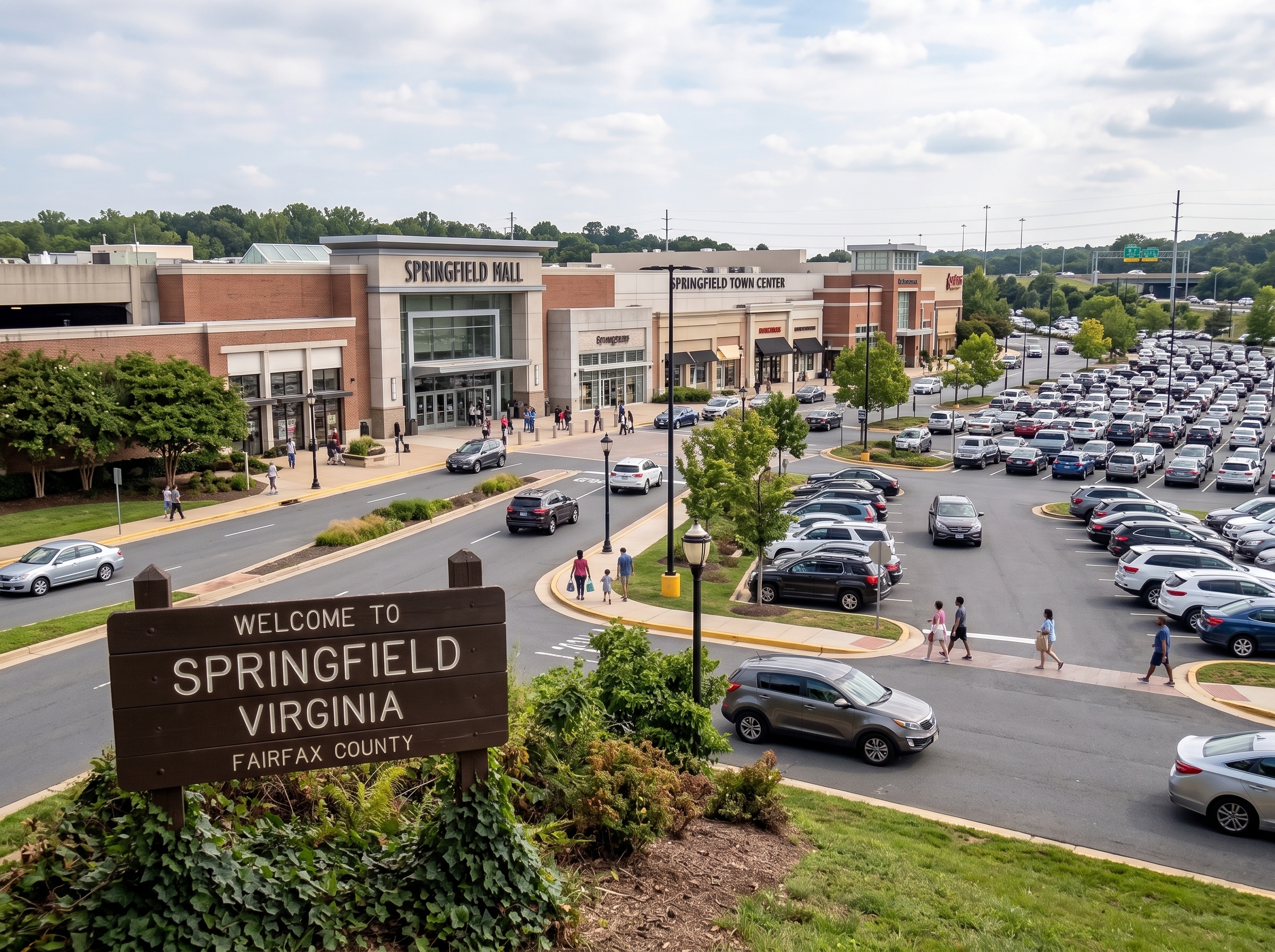
Springfield's real estate landscape is defined by pronounced geographic and architectural sub-districts. North Springfield serves as an intact preserve of 1950s red brick ramblers on generous wooded lots; West Springfield is renowned for its rolling topography, expansive colonial revivals, and the prestigious West Springfield High School academic pyramid; and Central Springfield provides an urbanized transit nexus centered upon the Franconia-Springfield Metrorail and Virginia Railway Express (VRE) station, alongside the Springfield Town Center.
The Six Structural Pillars of Springfield Real Estate
- The Springfield Interchange "Mixing Bowl" Super-Nexus. Direct convergence of Interstate 95, Interstate 395, and the Interstate 495 Capital Beltway, alongside the Fairfax County Parkway (Route 286), delivering unparalleled multi-directional highway connectivity across the Mid-Atlantic.
- Dual Heavy-Rail Transit Intermodal Core. The Franconia-Springfield transportation center housing the southern terminal of the Washington Metro Blue Line, an active commuter station on the Virginia Railway Express (VRE) Fredericksburg Line, and regional bus concourses.
- Distinct Geographic Housing Tiers. From mid-century masonry ramblers in North Springfield to rolling wooded colonials in West Springfield and modern townhome enclaves, providing diverse residential typologies across every lifestyle stage.
- Elite Academic Feeder Pyramids. The decorated West Springfield High School and Lake Braddock Secondary School pyramids within Fairfax County Public Schools (FCPS), featuring specialized AP, honors STEM, and celebrated performing arts academies.
- Accotink & Pohick Watershed Greenways. Hundreds of acres of protected natural parkland, encompassing Lake Accotink Park, Hidden Pond Nature Center, and continuous regional multi-use trail networks.
- Retail & Employment Gravity. Anchored by the 1.3-million-square-foot Springfield Town Center, the National Geospatial-Intelligence Agency (NGA) at nearby Fort Belvoir North Area, and extensive commercial hubs along Old Keene Mill Road.
2. Comprehensive Historical Evolution
Springfield's emergence as a dominant suburban engine represents the direct convergence of nineteenth-century railroad engineering, strategic Civil War logistical battles, and pioneer post-World War II master-planned suburbanization.
The Orange & Alexandria Railroad & 1847 Station Roots
The community owes its name and foundational infrastructure to the chartering of the Orange and Alexandria Railroad (O&A) in the late 1840s. Engineered to connect the Potomac River port of Alexandria with Gordonsville in the Virginia Piedmont, the railway established a rural depot in 1847 designated as "Springfield Station."
The depot was named in honor of the nearby plantation estate of Richard Wheeler, an early nineteenth-century planter whose farm was renowned for its natural freshwater springs. The station functioned as an agricultural transshipment hub where regional dairy farmers, timber mills, and orchard growers loaded freight for transport into the river wharves of Alexandria and Washington, D.C.
Civil War Rail Raids & Tactical Clashes (1861–1865)
As the single rail artery supplying Federal armies operating in northern and central Virginia, the Orange and Alexandria line through Springfield became a frequent target of Confederate reconnaissance. In October 1861, Confederate cavalry under General J.E.B. Stuart skirmished with Union pickets near Springfield Station.
Throughout the war, Colonel John S. Mosby and his partisan rangers executed daring strikes against Union supply trains, tearing up track and cutting telegraph wires between Springfield and Burke Station. Union engineers fortified Springfield Station with earthen redoubts and stationed armed blockhouses to safeguard the railway until the conclusion of hostilities.
Edward R. Carr & The Post-WWII Suburban Vanguard (1950)
Following World War II, visionary builder-developer Edward R. Carr recognized Springfield's geographic potential as the gateway to the expanding federal government workforce. In 1950, Carr purchased expansive tracts of dairy pastures surrounding the intersection of Backlick Road and the projected path of the Shirley Highway (now I-395).
Carr platted Crestwood and Springfield Estates, introducing mass-scale post-war residential planning to southern Fairfax County. Carr incorporated wide residential avenues, dedicated elementary school sites, and community commercial shopping centers. The success of Carr's developments catalyzed westward suburban growth throughout the 1960s and 1970s, establishing the neighborhoods that comprise modern West Springfield.
3. Physical Geography, Topography & Hydrology
Geologically situated within the upland Piedmont physiographic province, Springfield displays rolling terrain with elevations ranging from 210 feet in stream valleys to nearly 390 feet on ridge summits in West Springfield. The bedrock consists of crystalline metamorphic schist and granitic gneiss, capped by well-drained silt-loam soils that support dense native forests of white oak, American beech, and tulip poplar.
Springfield's hydrological network is divided into two major environmental basins:
- The Accotink Creek Watershed: Flowing through northern and central Springfield, Accotink Creek feeds directly into the 55-acre impoundment of Lake Accotink. The basin creates expansive alluvial floodplains and steep wooded ravine topologies that physically buffer residential neighborhoods.
- The Pohick Creek Watershed: Draining southwestern Springfield and Rolling Valley, Pohick Creek and its tributaries flow southeast toward Pohick Bay and the Potomac River, forming the natural spine of Hidden Pond Nature Center and the South Run stream valley.
Environmental protection is mandated by the Chesapeake Bay Preservation Act (CBPA) and Fairfax County environmental ordinances. Parcels abutting Accotink Creek, Pohick Creek, or classified perennial streams are encumbered by statutory 100-foot Resource Protection Area (RPA) vegetative buffer corridors. Within an RPA, the removal of mature canopy trees, soil grading, and the construction of impermeable improvements (such as structural additions, detached garages, or swimming pools) are legally prohibited without formal county environmental exceptions and water quality impact mitigation.
4. The Complete Springfield Neighborhood Dossier
Springfield is delineated into distinct residential micro-enclaves, each defined by unique vintage, topography, and community association structures.
North Springfield (ZIP 22151)
Developed in the mid-to-late 1950s north of Braddock Road and Little River Turnpike borders, North Springfield stands as one of Northern Virginia's most cohesive mid-century suburban communities. Characterized by classic single-story brick ramblers, daylight basements, and mature tree-lined streets, the community features generous lots averaging 0.28 to 0.38 acres. The neighborhood operates as a fee-simple non-HOA enclave with an active voluntary civic association, a private community swim club, and direct walkability to Lake Accotink Park.
West Springfield & Rolling Valley (ZIP 22152 & 22153)
Extending west along Old Keene Mill Road toward Burke, West Springfield represents the affluent residential core of the submarket. Developed primarily between 1968 and 1985, neighborhoods here feature rolling wooded hills, traditional two-story center-hall colonials, split-levels, and contemporary multi-level homes. Prominent subdivisions include:
- Orange Hunt Estates: A premier established community featuring traditional brick colonials, active community swimming pools, walking paths, and immediate proximity to the West Springfield High School academic campus.
- Rolling Valley & Rolling Valley West: Highly desirable residential subdivisions offering spacious four- and five-bedroom colonials and split-levels, anchored by neighborhood swim clubs and commuter park-and-ride lots.
- Saratoga: Positioned in southern Springfield (22153) off Rolling Road, Saratoga features single-family colonials and integrated townhome clusters, bordered by South Run stream valley parkland.
- Keene Mill Woods & Charlestown: Signature townhome enclaves featuring classic brick colonial architecture, landscaped courtyards, and low-maintenance homeownership within minutes of the Fairfax County Parkway.
Central Springfield (ZIP 22150)
Encompassing the historic post-war core developed by Edward Carr, Central Springfield features early 1950s ramblers in Crestwood, alongside modern transit-oriented mixed-use developments, condominium complexes, and urban townhomes clustered adjacent to the Franconia-Springfield Metrorail terminal and the Springfield Town Center.
5. Architectural Typologies
Springfield's residential housing inventory provides a comprehensive physical timeline of post-war suburban architecture:
- Mid-Century Red Brick Ramblers (1952–1962): Predominant across North Springfield and Crestwood. Solid masonry construction, single-story living, low-pitch gables, large picture windows, and full lower-level daylight basements that provide structural flexibility for modern open-concept remodeling.
- Split-Level & Split-Foyer Designs (1964–1976): Engineered to adapt to West Springfield's rolling Piedmont topography. These homes feature staggered multi-level floor plans separating entertainment areas from private bedroom quarters and lower-level family recreation rooms.
- Two-Story Center-Hall Colonials (1970–1985): The dominant typology across West Springfield, Orange Hunt, and Rolling Valley. Symmetrical brick facades, formal entry foyers, formal living and dining rooms, four upstairs bedrooms, attached two-car garages, and rear wood decks overlooking wooded parcels.
- Colonial Brick Townhouses (1975–1995): Three-level townhome architecture featuring brick fronts, walk-out finished lower levels, private fenced patios, and integrated single-car garages in newer clusters.
- 21st-Century Infill Estates: High-end custom homes replacing older housing stock on select half-acre parcels, showcasing modern craftsman architecture, multi-zone HVAC, gourmet chef kitchens, and three-car side-loading garages.
6. Municipal Zoning & Land-Use Governance
Land use across Springfield is governed exclusively by the Fairfax County Zoning Ordinance (zMOD), administered by the Fairfax County Department of Land Development Services (LDS).
Residential Zoning Districts
Residential neighborhoods fall under distinct county zoning classifications:
- R-2 District (Residential, Two Units/Acre): Applied to larger-lot parcels in West Springfield, requiring a minimum lot area of 20,000 square feet, a 100-foot lot width, and 35-foot front setbacks.
- R-3 District (Residential, Three Units/Acre): The dominant single-family classification across North Springfield and West Springfield subdivisions. Requires a minimum lot size of 10,500 square feet, an 80-foot lot width, and a maximum building height of 35 feet.
- R-5 & R-8 Districts (Residential Townhome Clusters): Governing medium-density planned townhome developments, regulating cluster common areas, minimum setback buffers, and assigned parking ratios.
The Springfield Commercial Revitalization Area (CRA)
Central Springfield is designated as a Commercial Revitalization Area by the Fairfax County Board of Supervisors. This policy framework promotes the transformation of auto-centric commercial centers around the Town Center and transit station into pedestrian-friendly, mixed-use urban villages with enhanced architectural design standards, structured parking, and multimodal connectivity.
7. Educational Ecosystem & School Pyramids
Public education across Springfield is provided by Fairfax County Public Schools (FCPS), consistently ranked among the elite public educational systems in the United States. Springfield residential properties are mapped into several high-performing academic pyramids.
The West Springfield High School Pyramid
The educational flagship of the submarket is West Springfield High School (Spartans), situated on Rolling Road. Following a comprehensive multi-million-dollar modern campus renovation, West Springfield High offers extensive Advanced Placement (AP) curricula, state-recognized STEM academies, championship athletics in VHSL Class 6, and celebrated fine arts and instrumental music programs.
The secondary school is fed by Irving Middle School (grades 7–8) and highly regarded elementary feeder schools, including Hunt Valley Elementary, Orange Hunt Elementary (noted for its German Immersion program), Rolling Valley Elementary, and West Springfield Elementary.
Lake Braddock Secondary School & John R. Lewis High School
Select residential sectors feed into alternate prestigious FCPS pyramids:
- Lake Braddock Secondary School: Serving northwestern sectors of Springfield, Lake Braddock accommodates grades 7 through 12 on an expansive single campus, renowned for its AP Capstone diploma program and academic decathlons.
- John R. Lewis High School: Serving central and eastern Springfield, offering the rigorous International Baccalaureate (IB) Diploma Programme, career technical academies, and global leadership initiatives.
Qualified secondary students across all Springfield pyramids are eligible through competitive regional evaluation to attend the nation's top-ranked Thomas Jefferson High School for Science and Technology (TJHSST), located directly north in nearby Annandale.
8. Multi-Modal Commuting & Regional Arterials
Springfield represents the ultimate multi-modal transit powerhouse in southern Northern Virginia, providing unmatched highway, rail, and bus connectivity.
- The Springfield Interchange ("Mixing Bowl"): One of the most sophisticated highway junctions in the nation, seamlessly integrating Interstate 95, Interstate 395, and Interstate 495 with direct access to the 95 Express Lanes and 495 Express Lanes. Enables dynamic commutes north into Washington, D.C., east across the Woodrow Wilson Bridge to Maryland, and south to Quantico and Richmond.
- The Franconia-Springfield Intermodal Center: A premier dual-rail transit facility housing the southern terminus of the Washington Metro Blue Line (direct heavy-rail transit to the Pentagon, Reagan National Airport, and central D.C.) and an active commuter platform on the Virginia Railway Express (VRE) Fredericksburg Line.
- Fairfax County Parkway (Route 286): Providing an unobstructed multi-lane highway connection across Fairfax County, linking Springfield directly to Burke, Fair Lakes, Reston, and the Dulles Tech Corridor.
- Extensive Bus Transit Networks: The regional concourse at the Metro station provides seamless connections to multiple Fairfax Connector routes and WMATA Metrobus express lines, offering one-seat transit into major employment centers.
9. Parks, Community Life & Civic Institutions
Springfield balances tremendous transit and commercial density with extensive protected parklands and recreational infrastructure:
Lake Accotink Park
Covering 493 protected acres along Springfield's northern perimeter, Lake Accotink Park surrounds a scenic 55-acre freshwater lake. Amenities include non-motorized boat rentals, canoe and kayak launches, miniature golf, a historic antique carousel, shaded pavilions, and the 3.7-mile paved loop trail directly connecting to the 40-mile Gerry Connolly Cross County Trail.
Hidden Pond Nature Center & Pohick Stream Valley
Situated off Greeley Boulevard in West Springfield, Hidden Pond Nature Center spans 25 acres of tranquil wetlands, native hardwood forest, and freshwater ponds. The facility features indoor wildlife exhibits, interpretive nature programs, and accessible boardwalk trails connecting directly to the continuous Pohick Stream Valley Park.
South Run RECenter Access
Located just minutes from southwestern Springfield along the parkway, the South Run RECenter offers an Olympic-sized indoor swimming pool, state-of-the-art two-story fitness center, synthetic-turf athletic fields, off-leash dog park, and direct paved trailheads connecting to Burke Lake Park.
Springfield Town Center & Dining Landscapes
Completely redeveloped into a premier 1.3-million-square-foot contemporary town center, the Springfield Town Center anchors regional commerce. It features high-end department stores, boutique retail, a state-of-the-art Regal cinema complex, upscale fitness facilities, and diverse international restaurants.
10. Fiscal Architecture, Taxation & HOA Nuances
Real estate ownership across Springfield is governed by Virginia statutory law and Fairfax County fiscal administration.
Virginia Code Title 58.1 & Annual Fair Market Assessment
In accordance with Virginia Code Title 58.1, all real property in Springfield is assessed annually at 100 percent of fair market value by the Fairfax County Department of Tax Administration (DTA). Assessments are computed through statistical modeling of arms-length neighborhood sales, structural improvements, and physical depreciation.
The Unincorporated Fiscal Advantage
Because Springfield is an unincorporated community rather than an incorporated town (such as Vienna or Herndon) or an independent city, property owners pay a single unified real estate tax bill to Fairfax County. Homeowners are not subject to secondary town-level real estate levies, resulting in an efficient overall tax structure while retaining full access to county public safety, schools, and infrastructure.
Fee-Simple Freedom vs. Mandatory Planned HOAs
The governance structure in Springfield varies distinctly by neighborhood vintage:
- Non-HOA Fee-Simple Subdivisions: North Springfield and early West Springfield neighborhoods are completely non-HOA. Homeowners pay no mandatory monthly dues and are free from private architectural review committees, operating solely under Fairfax County zoning codes.
- Mandatory Planned Community HOAs: Subdivisions developed from the 1970s onward (such as Orange Hunt, Rolling Valley, Saratoga, and all townhome communities) operate under mandatory community associations. These HOAs collect modest quarterly dues to maintain common open spaces, private community pools, tennis and pickleball courts, and enforce architectural guidelines to safeguard long-term curb appeal and equity.
11. Strategic Buyer Guidance
Prospective purchasers acquiring residential real estate in Springfield should execute targeted due diligence:
- Basement Waterproofing & Sump Pump Systems: In 1950s and 1960s homes in North Springfield and Central Springfield, inspect foundation block walls for step cracks, moisture staining, and efflorescence. Verify exterior grading slope and the presence of interior French drain tile systems and battery-backup sump pumps.
- Sewer Lateral Infrastructure: Commission a professional video camera sewer scope inspection of the main lateral line connecting the residence to the street main. Older clay and cast-iron lines can suffer from tree root intrusion or channel rotting.
- RPA & Floodplain Verification: Properties bordering Accotink Creek, Pohick Creek, or seasonal drainages must be verified against county GIS environmental overlays. Statutory 100-foot RPA buffers legally prohibit clearing or construction in rear yards.
- Commuter Route Field Testing: Test morning rush-hour transit times from candidate properties, evaluating access to the Franconia-Springfield Metro/VRE station vs. the I-395 Express Lanes entrance.
12. Strategic Seller Guidance
Homeowners preparing to list property in Springfield should execute specific positioning strategies:
- Highlight Transit Multi-Modality: Detail door-to-door transit times to the Pentagon, Amazon HQ2, Fort Belvoir, and downtown Washington, D.C. Emphasize proximity to the Metro Blue Line, VRE commuter rail, and Express Lanes.
- Showcase Academic Pyramid Affiliation: Homes feeding into the West Springfield High School or Lake Braddock Secondary School pyramids command substantial liquidity; feature school boundaries prominently in all marketing.
- Pre-Listing Mechanical & Structural Documentation: In mature colonials and ramblers, providing clean inspection reports verifying recent roof replacements, updated 200-amp electrical panels, and serviced dual-zone HVAC systems eliminates buyer friction and accelerates transaction velocity.
13. Submarket Comparative Matrix
The following analytical matrix compares Springfield with neighboring Northern Virginia residential submarkets:
| Submarket | Governance Structure | Dominant Housing Stock | Typical Lot Dimensions | Transit & Highway Access | HOA Prevalence |
|---|---|---|---|---|---|
| Springfield | Unincorporated Fairfax County (Franconia/Springfield Districts) | Brick Ramblers, Split-Levels, 1970s Colonials, Townhomes | 0.22 to 0.45 Acres | I-95/395/495 Interchange, Metro Blue Line, VRE Fredericksburg Line | Mix of Non-HOA (North) and Mandatory HOAs (West) |
| Burke | Unincorporated Fairfax County (Braddock/Springfield Districts) | 1970s–1980s Colonials, Planned Townhomes, Cluster Homes | 0.20 to 0.35 Acres | Burke Centre VRE Commuter Rail, Fairfax County Parkway | Highly Governed (Burke Centre Master Conservancy) |
| Kingstowne | Unincorporated Fairfax County (Franconia District) | Master-Planned Luxury Townhouses, Mid-Rise Condos, Single-Family | 0.06 (Townhome) to 0.25 Acres | Franconia-Springfield Metro Access, Van Dorn Corridor, Parkway | Universal Mandatory Master HOA (KROC) |
| Annandale | Unincorporated Fairfax County (Mason/Braddock Districts) | Mid-Century Brick Ramblers, Contemporary Timber Homes | 0.30 to 0.55 Acres | Direct I-495 Beltway, Express Lanes, Rt 236, Express Metrobus | Predominantly Non-HOA Fee-Simple |
| Fairfax Station | Unincorporated Fairfax County (Springfield District) | Custom Luxury Estates, Multi-Acre Executive Colonials | 1.00 to 5.00+ Acres | Route 123 (Ox Road), Fairfax Station VRE, Parkway | Mix of Large-Lot Non-HOA and Custom Estate HOAs |
14. 10 Comprehensive Evergreen FAQs
1. How is Springfield, Virginia structured politically and geographically?
Springfield is an unincorporated census-designated place (CDP) in southern and central Fairfax County spanning ZIP codes 22150, 22151, 22152, and 22153. It is not an incorporated municipality. Local governance is administered directly by the Fairfax County Board of Supervisors across the Franconia (formerly Lee) and Springfield Magisterial Districts. Geographic sub-sectors include North Springfield (22151), West Springfield (22152/22153), and Central Springfield (22150).
2. What is the historical origin of Springfield, Virginia?
Springfield originated in 1847 with the construction of the Orange and Alexandria Railroad, when a station was established and named "Springfield Station" after the estate of Richard Wheeler, an early 19th-century landowner. Modern suburban expansion commenced in 1950 when visionary developer Edward R. Carr platted a master-planned community near the rail junction, paving the way for post-war suburban growth across Fairfax County.
3. What is the Springfield Interchange and how does it affect real estate?
The Springfield Interchange—historically known as the "Mixing Bowl"—is the monumental junction of Interstate 95, Interstate 395, and Interstate 495 (Capital Beltway). Completely reconstructed into a multi-level grade-separated highway nexus, it provides Springfield residents with unmatched multi-directional highway accessibility to Washington, D.C., Tysons, Fort Belvoir, Old Town Alexandria, and Richmond.
4. What public transit infrastructure serves Springfield residents?
Springfield houses the premier intermodal transit hub in southern Northern Virginia: the Franconia-Springfield station. It functions as the southern terminus of the Washington Metro Blue Line, an active commuter stop on the Virginia Railway Express (VRE) Fredericksburg Line, a primary transfer center for Fairfax Connector and Metrobus networks, and a regional park-and-ride facility.
5. What architectural styles predominate in Springfield?
Springfield showcases diverse post-war residential architecture. North Springfield features classic 1950s red brick ramblers on full basements. Central and West Springfield feature late 1960s to 1980s split-levels, split-foyers, and two-story colonial revivals, complemented by expansive townhome communities (such as Keene Mill Woods and Rolling Valley) and modern infill estates.
6. Which public high school pyramids serve Springfield?
Residential sectors of Springfield are served primarily by Fairfax County Public Schools (FCPS) pyramids: West Springfield High School (celebrated for its Advanced Placement curricula, STEM academics, and performing arts), John R. Lewis High School, and Lake Braddock Secondary School (serving grades 7 through 12). Select southern fringes feed into South County High School.
7. How does Lake Accotink Park enhance the residential quality of Springfield?
Lake Accotink Park is a 493-acre regional park encompassing a 55-acre freshwater impoundment. It provides Springfield residents with miles of hiking and cycling trails along the Gerry Connolly Cross County Trail, non-motorized boat rentals, historic antique carousel rides, and a permanent wooded greenway buffer protecting water quality under the Chesapeake Bay Preservation Act.
8. Do neighborhoods in Springfield have mandatory Homeowners Associations (HOAs)?
The older single-family subdivisions in North Springfield and early West Springfield are largely fee-simple non-HOA neighborhoods with no mandatory association assessments. Conversely, planned subdivisions built from the 1970s onwards (such as Orange Hunt, Rolling Valley, and virtually all townhome communities) feature active mandatory HOAs regulating architectural changes and managing community pools and recreational amenities.
9. How are real estate taxes assessed in Springfield?
Under Virginia Code Title 58.1, all real property in Springfield is assessed annually at 100 percent of fair market value by the Fairfax County Department of Tax Administration. Because Springfield is unincorporated, property owners pay only the single Fairfax County base real estate levy and the county stormwater service district assessment, avoiding secondary town municipal taxes.
10. What retail and lifestyle hubs anchor Springfield?
Springfield is anchored by the Springfield Town Center—a completely redeveloped 1.3-million-square-foot contemporary retail, dining, and entertainment destination. It is complemented by Old Keene Mill Shopping Center, Rolling Valley Mall, and diverse international dining plazas along Backlick Road and Franconia Road.
15. Legal & Fair Housing Disclaimer
This real estate and community monograph is published solely for educational, demographic, and historical research purposes. All municipal boundaries, zoning districts, school attendance zones, tax assessments, and transportation frameworks are derived from official Fairfax County public records, the Virginia Department of Transportation (VDOT), and the Code of Virginia, and are subject to periodic administrative modification. Prospective purchasers, sellers, and investors must independently verify specific parcel zoning classifications, deed covenants, Resource Protection Area (RPA) boundaries, and school boundaries with relevant county agencies prior to executing contractual agreements. This publication strictly adheres to Title VIII of the Civil Rights Act of 1968 (The Federal Fair Housing Act) and the Virginia Fair Housing Law, prohibiting discrimination on the basis of race, color, religion, sex, handicap, familial status, elderliness, or national origin.