
West Falls Church, VA Real Estate: The Definitive Guide to Transit-Oriented Development, W&OD Trail Living & Residential Enclaves
Executive Summary & Essential Community Takeaways
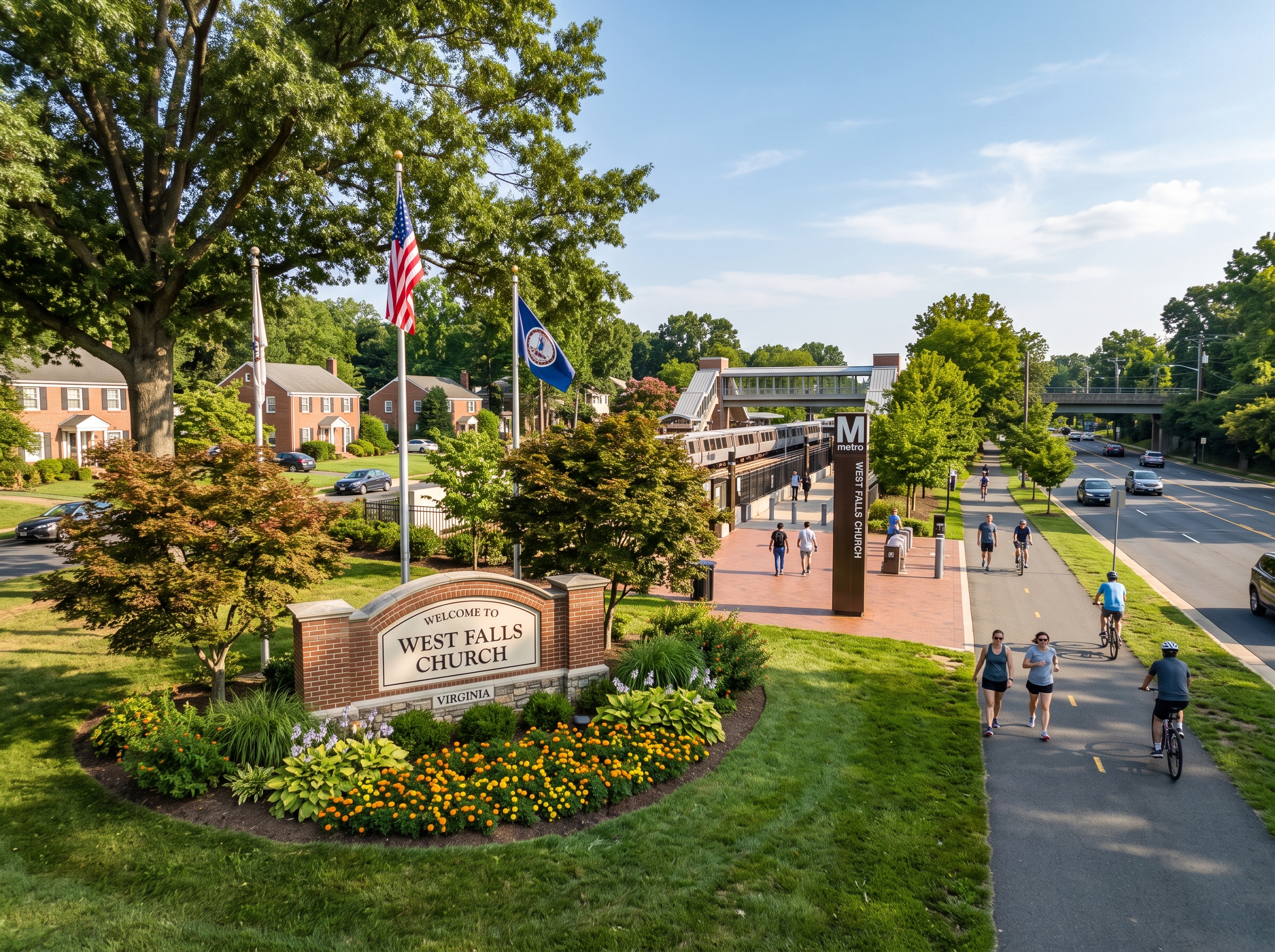
- Multimodal Regional Nexus: West Falls Church is an unincorporated census-designated place in Fairfax County's Providence Magisterial District, distinguished by direct access to the West Falls Church–VT/UVA Metrorail Station (Orange Line), Interstate 66, Route 7, and Route 267.
- 24-Acre Metro Transit-Oriented Development (TOD): A premier joint development partnership between WMATA, Fairfax County, and EYA/Rushmark/HITT, transforming former commuter parking lots into a walkable urban village with luxury townhomes, multi-family residences, civic gathering plazas, and corporate offices.
- W&OD Trail Recreational Spine: The 45-mile paved Washington & Old Dominion Railroad Regional Park bisects the community, functioning as an essential non-motorized commuter superhighway connecting residents directly to Tysons, Arlington, and regional stream valleys.
- Diverse Housing Continuum: Features quiet mid-century single-family neighborhoods (such as Shrevewood, Poplar Heights, and Jefferson Village) with solid brick ramblers and split-levels, alongside custom modern luxury infill, transit-adjacent townhomes, and modern condominiums.
- Premier FCPS Academic Pyramids: Primary attendance zones feed into the George C. Marshall High School International Baccalaureate (IB) World School pyramid and the modernized Falls Church High School campus, supported by Kilmer Middle School (AAP Level IV Center) and Shrevewood Elementary.
- Statutory Assessment Standards: Property assessments adhere strictly to Virginia Code Title 58.1-3201 statutory 100 percent fair market value standards administered through annual Department of Tax Administration (DTA) equalization cycles.
1. Spatial Morphology, Boundaries & Regional Context
West Falls Church represents one of Northern Virginia’s most strategically connected suburban enclaves. Situated in the eastern portion of Fairfax County within the Providence Magisterial District (postal ZIP code 22043), this unincorporated census-designated place (CDP) sits directly between the high-density tech capital of Tysons to the west, the independent municipality of the City of Falls Church to the east, and McLean to the north.
Covering approximately five square miles, West Falls Church is defined by critical natural corridors and engineered transit rights-of-way:
- North Boundary: State Route 7 (Leesburg Pike) and the Capital Beltway (Interstate 495) interchange, linking directly to Tysons Galleria, McLean, and the Dulles Access Road corridor.
- East Boundary: The municipal corporate border of the independent City of Falls Church, following Haycock Road, Great Falls Street, and West Street.
- South Boundary: Interstate 66 (Custis Memorial Parkway) and Lee Highway (US Route 29), providing direct freeway access eastward into Arlington and Washington, D.C.
- West Boundary: Idylwood Road, Gallows Road, and the stream valley parklands of Tripps Run, transitioning toward the Merrifield and Dunn Loring submarkets.
2. Historical Evolution: The W&OD Railroad, Post-War Expansion & The Metrorail Era
The spatial development of West Falls Church has been guided for over a century and a half by the intersection of regional railroad engineering and modern highway planning.
The Washington & Old Dominion (W&OD) Railroad (1859–1968)
The foundational spine of West Falls Church was established in the mid-nineteenth century by the construction of the Alexandria, Loudoun & Hampshire Railroad (later chartered as the Washington & Old Dominion Railroad). Operating freight and passenger service between Alexandria, Leesburg, and the Shenandoah Valley, the railroad maintained crucial whistle-stops and freight sidings in West Falls Church to transport milk, fruit, timber, and granite.
During the Civil War, the rail line was contested, suffering extensive sabotage before serving as a vital Union military supply artery. Rail operations ceased in 1968, after which the Northern Virginia Regional Park Authority (NOVA Parks) acquired the abandoned roadbed, systematically converting it into the 45-mile W&OD Railroad Regional Park. Today, this historic right-of-way functions as the ecological and non-motorized commuter superhighway of West Falls Church.
Post-WWII Suburban Subdivisions (1950–1975)
With the rapid growth of the federal government following World War II and the subsequent construction of the Capital Beltway (I-495) and Interstate 66, dairy farms and orchards in West Falls Church were acquired by regional residential builders. Established subdivisions—including Shrevewood, Poplar Heights, and Jefferson Village—were platted, delivering sturdy single-family brick ramblers and split-levels for growing post-war households seeking generous yards and seamless commuter access.
The Metrorail Revolution & Virginia Tech Campus (1986–Present)
In June 1986, the Washington Metropolitan Area Transit Authority (WMATA) opened the West Falls Church–VT/UVA Metrorail Station along the median of Interstate 66 as part of the Orange Line extension. Serving as the western terminus of the Orange Line for several years, the station transformed West Falls Church into a major multimodal transit hub.
Adjacent to the station, Virginia Tech and the University of Virginia established the Northern Virginia Center, creating an institutional anchor for graduate engineering, computer science, and regional research. Today, the surrounding station parcels are undergoing a multi-million-dollar mixed-use transformation, representing one of the region’s premier suburban transit-oriented redevelopment programs.
3. Residential Enclaves, Neighborhood Typologies & Architectural Anatomy
West Falls Church features a mature residential fabric that balances established, tree-lined single-family neighborhoods with modern transit-oriented communities.
| Residential Subdivision / Enclave | Primary Architectural Style | Construction Era | Typical Lot Dimensions | Fairfax County Zoning |
|---|---|---|---|---|
| Shrevewood | Brick Ramblers, Split-Levels, Custom Infill | 1954 – 1968 | 0.25 to 0.40 Acre Lots | R-3 / R-4 (Single-Family Residential) |
| Poplar Heights | Mid-Century Ranchers & Split-Levels | 1952 – 1965 | 0.22 to 0.35 Acre Parcels | R-3 / R-4 (Suburban Single-Family) |
| Jefferson Village & Westmoreland Border | Cape Cods, Brick Cottages, Colonials | 1948 – 1962 | 0.20 to 0.30 Acre Lots | R-4 (Medium Density Single-Family) |
| Station Square & Village at West Falls Church | Multi-Level Brick Executive Townhomes | 1988 – 2002 | Platted Townhome Parcels | PDH-12 / R-12 (Planned Development) |
| West Falls Church Metro TOD (The Birch & EYA Homes) | Modern Urban Brownstones & Luxury Multi-Family | 2022 – Present | High-Density Transit-Oriented Parcels | PRM (Planned Residential Mixed-Use) |
| Custom Infill Estates (Scattered) | Transitional Craftsman & Modern Farmhouses | 2010 – Present | 0.25 to 0.45 Acre Replacement Lots | R-3 (Single-Family Infill) |
Shrevewood: Mature Tree Canopies & W&OD Trail Proximity
Bordered by Shreve Road, Virginia Avenue, and the W&OD Trail, Shrevewood is one of West Falls Church’s most sought-after single-family neighborhoods. Platted primarily during the 1950s, the subdivision features solid red-brick ramblers, split-foyer homes, and multi-tier split-levels. Properties are characterized by generous front lawn setbacks, deep rear yards, and direct neighborhood spur trails leading directly onto the paved W&OD Trail and Shrevewood Elementary School.
The West Falls Church Metro Mixed-Use TOD Village
Spanning 24 acres of former surface commuter parking adjacent to the West Falls Church Metrorail Station, this ongoing master-planned development represents the cutting edge of Northern Virginia smart-growth urbanism. Designed by EYA, Rushmark, and HITT in partnership with WMATA, the neighborhood integrates modern multi-story brick and stone townhomes with attached two-car garages, luxury multi-family apartment residences, ground-floor neighborhood retail, open civic green spaces, and direct pedestrian bridges into the Metrorail platform and the Virginia Tech Northern Virginia Center.
4. Structural Anatomy, Building Eras & Property Maintenance
Owning and evaluating real estate in West Falls Church requires specialized technical knowledge of mid-century building assemblies and modern infill construction standards:
Mid-Century Masonry Residences (1950–1970)
- Foundations & Soil Mechanics: Typically constructed with unreinforced concrete masonry unit (CMU) block or poured concrete crawl space and basement foundations. Properties built along natural stream slopes toward Tripps Run require functional exterior downspout extensions and positive perimeter grading slope to prevent subsurface moisture migration and hydrostatic pressure.
- Framing & Roof Assemblies: Built with true dimensional 2x4 framing studs and site-framed rafter systems utilizing solid 1x6 wood tongue-and-groove decking or early exterior-grade plywood sheathing. Upgrading to modern multi-layer architectural fiberglass asphalt shingles with continuous ridge vents is essential to ensure balanced attic ventilation.
- Electrical Service Capacity: Original installations often featured 60-amp or 100-amp split-bus electrical panels. Modern living demands upgrading to 200-amp circuit breaker panels with whole-home surge suppression, arc-fault circuit interrupters (AFCI), and ground-fault (GFCI) protection in wet locations to accommodate modern HVAC heat pumps and level-2 electric vehicle chargers.
- Plumbing Supply & Drainage Systems: Original branch supply lines were rigid copper (Type L or M), while drain-waste-vent (DWV) piping utilized heavy cast iron stacks. Homeowners should conduct fiber-optic camera sewer scope inspections of underground cast iron lines to evaluate for root penetration or internal rust scaling between the foundation wall and the municipal sewer main.
Custom Modern Infill Construction (2010–Present)
- Engineered Assemblies: Modern infill homes utilize engineered wood floor I-joists, laminated veneer lumber (LVL) structural support beams, and prefabricated high-pitch roof trusses.
- Energy Efficiency & Envelope Sealing: Incorporate advanced housewrap moisture barriers, closed-cell spray foam insulation, multi-zone variable-speed heat pumps, and thermally broken double- or triple-pane Low-E argon-insulated windows meeting modern Virginia Energy Conservation Code standards.
5. Public Education Infrastructure: FCPS School Pyramids & Academic Profiles
West Falls Church is served by Fairfax County Public Schools (FCPS), recognized nationally for academic achievement and advanced academic opportunities. The community is anchored primarily by the George C. Marshall High School Pyramid and the Falls Church High School Pyramid.
| School Facility | Grade Levels | Pyramidal Feeder Alignment | Curriculum Programs & Academic Honors |
|---|---|---|---|
| George C. Marshall High School | Grades 9 – 12 | Marshall Pyramid | Authorized International Baccalaureate (IB) World School, Full IB Diploma, Statesmen Academy |
| Falls Church High School | Grades 9 – 12 | Falls Church Pyramid | Comprehensive Modernization, Advanced Placement (AP), STEM Academy Labs, Visual & Performing Arts |
| Kilmer Middle School | Grades 7 – 8 | Marshall Pyramid | Full-Time Advanced Academic Programs (AAP Level IV Center), Accelerated Math & Science |
| Longfellow Middle School | Grades 7 – 8 | McLean Pyramid (Border) | Nationally Ranked Academic Decathlon, Honors Curriculum, Advanced World Languages |
| Shrevewood Elementary School | Pre-K – Grade 6 | Marshall Pyramid | Advanced Academic Programs (AAP), STEAM Initiatives, W&OD Outdoor Environmental Learning Lab |
| Lemon Road Elementary School | Pre-K – Grade 6 | Marshall Pyramid | Advanced Academic Programs (AAP), Eco-Schools USA Green Flag Award, Responsive Classroom |
| Haycock Elementary School | Pre-K – Grade 6 | McLean Pyramid (Border) | Full-Time Level IV AAP Center, National Blue Ribbon School of Excellence |
| Timber Lane Elementary School | Pre-K – Grade 6 | Falls Church Pyramid | Global Classroom Programs, Advanced Academic Talent Development, Inclusive Learning Labs |
The International Baccalaureate (IB) Diploma at Marshall High
George C. Marshall High School is an authorized International Baccalaureate (IB) World School, offering the rigorous, internationally acclaimed two-year IB Diploma Programme for eleventh and twelfth graders. Students engage in college-level seminars across six academic disciplines, author an independent 4,000-word Extended Essay, complete the Theory of Knowledge (TOK) capstone course, and participate in Creativity, Activity, Service (CAS) projects. Marshall graduates frequently matriculate to top-tier universities with substantial advanced collegiate standing.
Kilmer Middle School & Advanced Academic Programs (AAP)
Students zoned to Marshall High attend Kilmer Middle School, which functions as an official Full-Time AAP Level IV Center. Kilmer delivers an accelerated, depth-and-complexity curriculum in language arts, science, social studies, and accelerated mathematics (including Algebra I Honors and Geometry Honors). Furthermore, rising eighth graders in West Falls Church are eligible to participate in the competitive regional admissions process for Thomas Jefferson High School for Science and Technology (TJHSST) in nearby Lincolnia.
6. Transportation Logistics, Metrorail Access & Commuter Corridors
Few residential submarkets in the Washington metropolitan region rival West Falls Church for comprehensive, multimodal transportation logistics.
The West Falls Church–VT/UVA Metrorail Station (Orange Line)
Located directly within the community, the station offers a seamless, one-seat heavy-rail transit ride into:
- East Falls Church & Ballston-MU: 5 to 8 minutes.
- Rosslyn & Foggy Bottom (GWU): 14 to 18 minutes.
- Metro Center & Downtown Washington, D.C.: 20 to 24 minutes.
- Tysons & Reston Town Center: Rapid transfer to the Silver Line at East Falls Church.
Major Highway & Arterial Roadway Corridors
- Interstate 66 (Custis Memorial Parkway): Direct on-ramps provide express transit eastward directly across the Theodore Roosevelt Memorial Bridge into downtown Washington, D.C., and westward toward Fairfax, Vienna, and I-81.
- State Route 7 (Leesburg Pike): The primary diagonal spine connecting West Falls Church directly to Tysons Galleria and Tysons Corner Center in under five minutes, and southeastward toward Seven Corners and Alexandria.
- Capital Beltway (Interstate 495): Located immediately west, providing access to the 495 Express Lanes, Maryland, and the Woodrow Wilson Bridge.
- Route 267 (Dulles Toll Road / Airport Access Highway): Accessible within three minutes, providing rapid, non-stop access to Washington Dulles International Airport (IAD).
7. Environmental Topography, Geology & Protected Regional Parklands
West Falls Church is situated upon the rolling topography of the Piedmont Upland, characterized by mica schist and granitic bedrock cloaked in fertile, deep silt-loam soils. The landscape features scenic ridges falling toward deeply incised stream valleys that feed into the Potomac River basin.
The Washington & Old Dominion (W&OD) Trail Greenway
The 45-mile W&OD Railroad Regional Park is the premier ecological and recreational spine of West Falls Church. Paved with a continuous 10-foot-wide asphalt path accompanied by an adjacent crushed-gravel equestrian/foot trail, the greenway links West Falls Church to:
- Eastward: The City of Falls Church, Arlington County, and the Mount Vernon Trail along the Potomac River.
- Westward: Vienna, Reston Town Center, Herndon, and historic downtown Leesburg in Loudoun County.
Protected Parks & Forested Stream Corridors
- Idylwood Park: A 17-acre community park featuring lighted tennis courts, basketball courts, baseball fields, children's playground structures, and shaded picnic pavilions directly accessible from the W&OD Trail.
- Shrevewood Park: A tranquil neighborhood greenway featuring nature walking paths, mature hardwood forest groves, and community gathering spaces.
- Tripps Run Stream Valley: A protected natural environmental quality corridor (EQC) preserving riparian wetlands, native wildlife habitat, and stormwater flood management zones.
8. Real Estate Assessment Cycles & Virginia Statutory Tax Framework
Real estate taxation in West Falls Church is governed strictly under the statutory framework of the Commonwealth of Virginia and the administrative authority of Fairfax County. Because West Falls Church is an unincorporated community within Fairfax County, property owners pay municipal real estate taxes solely to Fairfax County, with zero supplemental city-level property tax levies.
Virginia Code Title 58.1-3201: The 100% Fair Market Value Mandate
Under Virginia Code § 58.1-3201, all real property in Virginia must be assessed for tax purposes at one hundred percent (100%) of its true fair market value. The Fairfax County Department of Tax Administration (DTA) conducts comprehensive annual reassessments of every taxable parcel in West Falls Church. Valuations are determined through annual market equalization based on verified arm's-length sales of comparable properties within identical neighborhood submarket codes, accounting for lot size, topography, structural improvements, and property condition.
Annual Assessment Calendar & Payment Schedules
- January 1 (Statutory Effective Date): Property assessments are legally established as of January 1 of each calendar year, reflecting real estate market transactions occurring during the preceding twelve months.
- Late February (Mailing of Assessment Notices): The DTA mails official Notice of Real Estate Assessment cards to all property owners, itemizing land value, building value, and total taxable assessment.
- Semi-Annual Payment Deadlines: Real estate tax payments in Fairfax County are billed in two equal installments:
- First Installment: Statutorily due on or before July 28.
- Second Installment: Statutorily due on or before December 5.
- Countywide Dedicated Levies: Properties in West Falls Church are subject to the Countywide Stormwater Management Service District Tax, dedicated to stream valley restoration, dam safety, and Chesapeake Bay runoff mitigation.
Statutory Assessment Appeals Mechanism
Property owners who believe their annual assessment exceeds fair market value, is non-uniform compared to contiguous properties, or contains clerical errors have the legal right to challenge the assessment through a formal two-tiered process:
- Administrative Review: An informal appeal submitted directly to the Department of Tax Administration, typically required by early April. An assigned county residential appraiser reviews structural data, square footage calculations, physical property condition, and relevant sales comps.
- Board of Equalization (BOE) Appeal: A formal evidentiary appeal submitted to the citizen-led Board of Equalization of Real Estate Assessments, typically requiring filing by June 1. If dissatisfied with the BOE ruling, property owners retain the statutory right to file a petition with the Circuit Court of Fairfax County under Virginia Code § 58.1-3984.
9. Frequently Asked Questions Regarding West Falls Church, VA Real Estate
Is West Falls Church an independent municipality or part of Fairfax County?
West Falls Church is an unincorporated census-designated place (CDP) situated directly within Fairfax County under the governance of the Fairfax County Board of Supervisors within the Providence Magisterial District. It is entirely distinct from the adjacent, independent City of Falls Church. Municipal services, public education (FCPS), police protection, and land-use zoning are administered by Fairfax County.
What is the West Falls Church Metrorail Station Transit-Oriented Development (TOD)?
The West Falls Church Metro TOD is a landmark 24-acre joint development project between the Washington Metropolitan Area Transit Authority (WMATA), Fairfax County, and development partners (EYA, Rushmark, and HITT). The initiative replaces underutilized surface parking lots with a walkable urban village featuring modern multi-family residences, luxury townhomes, corporate office spaces, civic gathering plazas, and dedicated bicycle infrastructure directly linked to the Orange Line.
What role does the Washington & Old Dominion (W&OD) Trail play in the community?
The historic 45-mile Washington & Old Dominion (W&OD) Railroad Regional Park bisects West Falls Church, serving as a primary non-motorized commuter superhighway and recreational spine. Residents utilize the paved trail for non-motorized commuting to Tysons, Arlington, and the East Falls Church Metro station, as well as running, walking, and cycling through contiguous stream valley parklands.
Which public schools serve West Falls Church residential neighborhoods?
West Falls Church is served by Fairfax County Public Schools (FCPS), primarily within the George C. Marshall High School pyramid (renowned for the International Baccalaureate Diploma Programme) and the Falls Church High School pyramid. Feeder schools include Kilmer Middle School (an AAP Level IV center), Longfellow Middle School, Shrevewood Elementary, Lemon Road Elementary, and Haycock Elementary.
What residential architectural typologies are found in West Falls Church?
Housing in West Falls Church features an attractive spectrum ranging from post-war 1950s and 1960s brick ramblers and split-levels on quarter-to-third-acre lots in subdivisions like Shrevewood and Poplar Heights, to custom modern luxury craftsman infill estates, established transit-adjacent townhome communities, and contemporary transit-oriented condominiums near the Metro station.
How does commuter connectivity operate from West Falls Church?
West Falls Church offers unmatched multimodal logistics, anchored by the West Falls Church-VT/UVA Metrorail Station (Orange Line) providing a direct one-seat ride to Arlington, Foggy Bottom, and downtown Washington, D.C. Vehicular commuters enjoy immediate access to Interstate 66, State Route 7 (Leesburg Pike), Route 267 (Dulles Toll Road), and the Capital Beltway (I-495).
What higher education and innovation facilities are located in West Falls Church?
The community is home to the Virginia Tech Northern Virginia Center, an established graduate education and research campus adjacent to the Metro station. The institution plays a pivotal role in regional innovation, computer science, and engineering education, anchoring the broader educational-tech corridor alongside the University of Virginia.
What environmental watersheds and parks characterize West Falls Church?
West Falls Church sits across the geological Fall Line transition, drained by tributaries of Tripps Run, Holmes Run, and Pimmit Run. Protected parks include Idylwood Park, Shrevewood Park, and the continuous greenway of the W&OD Trail, providing expansive athletic fields, tennis courts, and native oak-hickory woodland canopies.
What structural maintenance considerations are essential for mid-century homes in West Falls Church?
Purchasers of mid-century single-family properties should conduct fiber-optic camera sewer scope inspections to check for root intrusion or rust scaling in original underground cast iron lines, upgrade original 60-amp or 100-amp electrical panels to 200-amp circuit breakers with AFCI/GFCI protection, and inspect basement crawl space moisture barriers and drainage slopes.
How are real estate assessments governed in West Falls Church under Virginia law?
Under Virginia Code § 58.1-3201, all real property in West Falls Church is assessed annually at 100 percent of fair market value by the Fairfax County Department of Tax Administration (DTA). Assessment notices are mailed every February based on arm's-length market sales, with taxes paid semi-annually on July 28 and December 5, and formal administrative appeal rights through the county Board of Equalization.
10. Academic References, Transit Archives & Statutory Legal Disclaimers
This architectural monograph, transit planning analysis, and real estate reference treatise incorporates verified historical archives, public planning documents, and statutory legal frameworks:
- Fairfax County Comprehensive Plan: Area II, West Falls Church Transit Station Area (TSA) Guidance & Comprehensive TOD Master Plan, Fairfax County Department of Planning and Development, Fairfax, Virginia.
- Washington Metropolitan Area Transit Authority (WMATA): West Falls Church Joint Development Agreement & Station Area Multi-Modal Transportation Studies, Washington, D.C.
- Northern Virginia Regional Park Authority (NOVA Parks): Washington & Old Dominion (W&OD) Railroad Regional Park Master Plan & Historical Archives, Fairfax, Virginia.
- Fairfax County Public Schools (FCPS): Office of Facilities Planning, George C. Marshall High School and Falls Church High School Feeder Boundary Alignment Directory, Gatehouse Administration Center, Falls Church, Virginia.
- Code of Virginia (Statutory Authority): Title 58.1 (Taxation), § 58.1-3201 (Fair Market Value Mandates) and § 58.1-3370 (Board of Equalization Procedures), Commonwealth of Virginia, Richmond, Virginia.
- United States Geological Survey (USGS): Falls Church and Vienna 7.5-Minute Topographic Quadrangles, Tripps Run and Pimmit Run Hydrologic Surveys, Reston, Virginia.
Statutory Research & Regulatory Notice: This architectural monograph, transit planning review, and submarket treatise is published strictly for informational, educational, and spatial orientation purposes. Real estate boundaries, school attendance zones, Metrorail joint development phases, and tax assessment schedules are subject to ongoing administrative modifications by the Fairfax County Board of Supervisors, the Fairfax County School Board, WMATA, and the Virginia Department of Transportation (VDOT). This publication does not constitute formal appraisal valuations, structural architectural inspections, or legal counsel. Prospective purchasers and property owners must verify official parcel-specific records directly with the Fairfax County Department of Tax Administration (DTA) and Land Development Services (LDS).